To log this earthcache, please don’t stress about answering the questions. Simply send your best attempts in a private message to me, (the cache owner), and then go ahead and log it as found.
You don’t need to wait for my approval. All attempts will be accepted.
Go ahead and have fun learning! 
- [REQUIRED] Please post a photo in your log of yourself or a personal item at the waterfall to prove you visited the site.
- Do you see any evidence of weathering? Or just erosion?
- How many of the four main agents of erosion are at work in this waterfall?
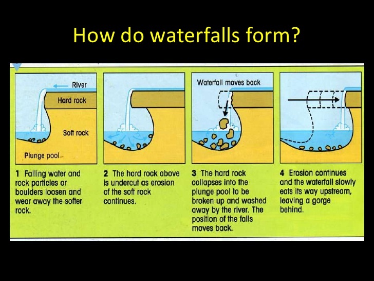
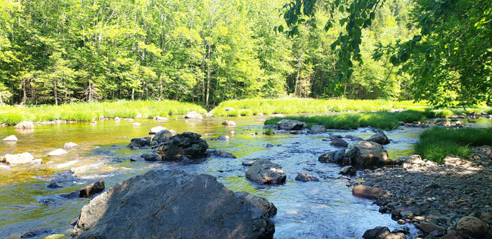
Waterfalls are areas where the flowing water drops abruptly and nearly vertically. These waterfalls represent major interruptions in the river flow. The typical river flow tends to smooth out irregularities in their flow by processes of erosion and deposition. In time, the long profile of a river takes the form of a smooth curve, steepest toward the source, gentlest toward the mouth. Waterfalls interrupt this curve, and their presence is a measure of the progress of erosion. Waterfalls of small height and lesser steepness such as these are called cascades. This term is often applied to a series of small falls along a river.
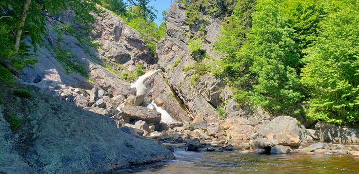
Economy Falls
A waterfall is a river or other body of water's steep fall over a rocky ledge into a plunge pool below. The process of erosion, the wearing away of earth, plays an important part in the formation of waterfalls. Waterfalls themselves also contribute to erosion.
Weathering vs Erosion
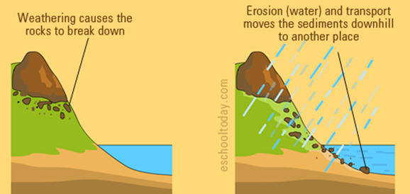
Erosion is the process by which soil and rock particles are worn away and moved elsewhere by gravity, or by a moving transport agent – wind, water or ice. Erosion in a waterfall is different from weathering because it involves the removal of solid material by a transporting agent. Transport is the processes by which the sediment is moved along a river-bed.
Weathering is the breakdown of rock into fragments at the Earth’s surface. No movement is involved in weathering. As a general rule, if a rock is just broken down through mechanical or chemical means, then weathering has occurred. If that broken-down material gets moved at all by water, wind or ice, then erosion has occurred.
Agents of Erosion
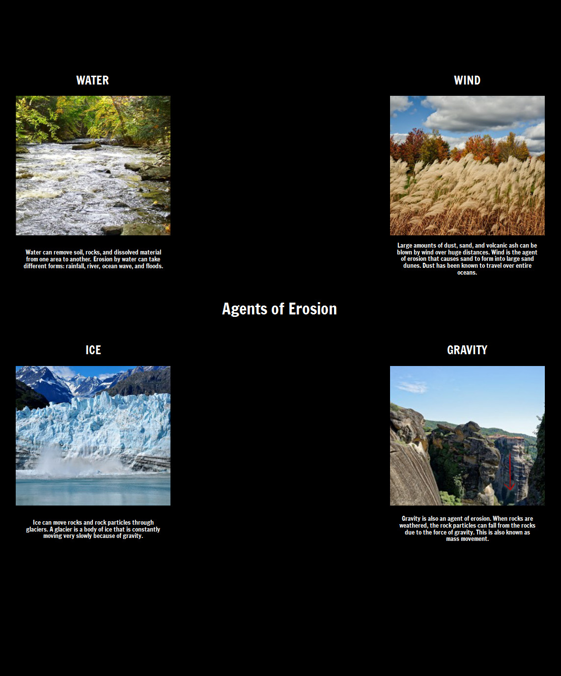
There are four main agents of erosion: moving water, wind, gravity, and ice wear away or break up rocks, sediments, and soil from the land's surface.
Water is perhaps the most important agent of erosion in a waterfall. Streams, depending on their size and speed, can erode away banks and bedrock and transport large pieces of sediment.
The waterfalls of Keys Brook formed as streams flowing from soft rock to hard rock. This happened both laterally (as the stream flows across the land) and vertically (as the stream drops in a waterfall). As the stream flows, it carries the sediment with it. The sediment varies between microscopic silt, pebbles, or even boulders. Sediment erodes the stream-beds made of soft rock, sometimes cutting the channel so deep into the stream bed that only the harder rock, such as granite, remains. The waterfalls developed as these granite formations form into ledges.
As you can see from this location, the stream's velocity increases as it nears a waterfall, increasing the amount of erosion taking place. The movement of water at the top of a waterfall can erode rocks to be very flat and smooth, allowing you to clearly see the surface of the rocks, which are washed clear of debris.
Rushing water and sediment topple over the waterfall, eroding the plunge pool at the base. The flow of the waterfall may also create powerful whirlpools that erode the rock of the plunge pool beneath them. Eventually, the rocky ledge (or the outcrop) may tumble down, sending boulders into the stream bed and plunge pool below. This pool area at the bottom of the waterfall is typically flatter in terrain, wider, and has slower moving water.
Waterfall pool
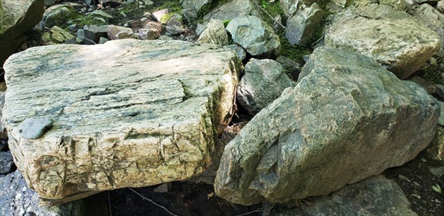
The rocks at the Economy Falls are along the Cobequid-Chedabucto fault. The grey gneiss rocks here are part of the oldest known continental crust in the microcontinent, Avalonia, from New England to Newfoundland. Originally an igneous rock similar to granite, it intruded into even older rock (ironstone), fragments of which can also be found along the trail. Later, the rocks were smeared out in a zone of intense deformation, giving them a unique mineral fabric. They are located along with the much younger Cobequid-Chedabucto fault system, which marks the southern boundary of Abalonia in Nova Scotia. The waterfall and trail here are located along the fault scarp, which forms a conspicuous topographic break across the region.
Two rocks types to compare:
 />
/>
Grey gneiss
Grey gneiss is the most common rock. Clean outcrops of the gneiss have a lined appearance, in places resembling a bundle of grey pencils. On water-smoothed boulders, you can clearly see the wavy, ribbon-like pattern caused by extreme deformation. Interlayered with the grey gneiss are conspicuous pink sheets of younger granite. It has a less extreme mylonitic fabric.
Ironstone
A second common rock here is ironstone. Look for boulders of very dark grey rock along the trail. These feel especially heavy because of their density. If you have one, you could use a magnet to see if the rocks attracts it. Known as ironstone due to its high iron content, this rock is older than the gneiss.