Originally, the South Fork of the Palouse River, starting at the main Palouse River (Colfax) all the way east to the Bitteroot Mountains on the Idaho/Montana Border was Nez Perce land. It was ceded to the United States with the treaty of 1855. The town of Troy, Idaho was originally known as Huffs Gulch when J. Wesley Seat homesteaded the area in 1885. In 1890, area businessman John P. Vollmer immodestly changed the name of the town to his last name when he bought foreclosed land caused by the then current depression. Rumor has it that the name was changed again by local citizens to "Troy" due to the suggestion of a local Greek railroad worker. The man suggested "Troy," the name of "the most illustrious city in the world" and backed it with an offer of a drink of whiskey for everyone who would vote to change the name. Troy was the name of the Bronze Age city attacked in the Trojan War, a popular story in the mythology of ancient Greece, and the name given to the archaeological site in the northwest of Asia Minor (now Turkey). "Troy" received 29 votes; "Vollmer" 9.
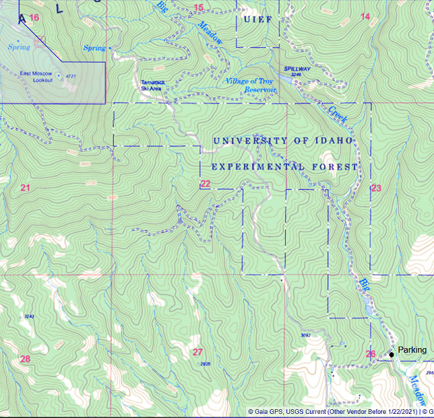
The Village of Troy Reservoir is a very small man-made reservoir in the Palouse Range of mountains just east of East Moscow Mountain. Originally, it was created as part of the City of Troy Water Supply. Under the Idaho Rural Water Association, it is a Drinking Water Protection Area - so you probably shouldn't swim in it.
To get to the area of the reservoir and the geocache, it will require about two miles of hiking through the University of Idaho's College of Natural Resources Experimental Forest. This is a beautiful area that starts out with big ponderosa pines and takes you into a sylvan ravine full of huge cedar trees and a small bubbling stream (Big Meadow Creek). The trail is an old logging road that has been gated and does not allow motorized vehicles. The public is allowed on these lands, however, please obey the guidelines found <here>
To get to the parking area from Troy, get on Big Meadow Creek Road and follow it all the way to where it ends at the gate. As I said above, the land is owned by the University of Idaho and hiking, biking, horseback riding and skiing & snowshoeing are allowed in the area. You might want to pack a picnic lunch as there are a few nice spots along the creek that are perfect for stopping, having a light meal and taking in the scenery.
While you're out here, try looking for GCW9RH - another geocache in the area.