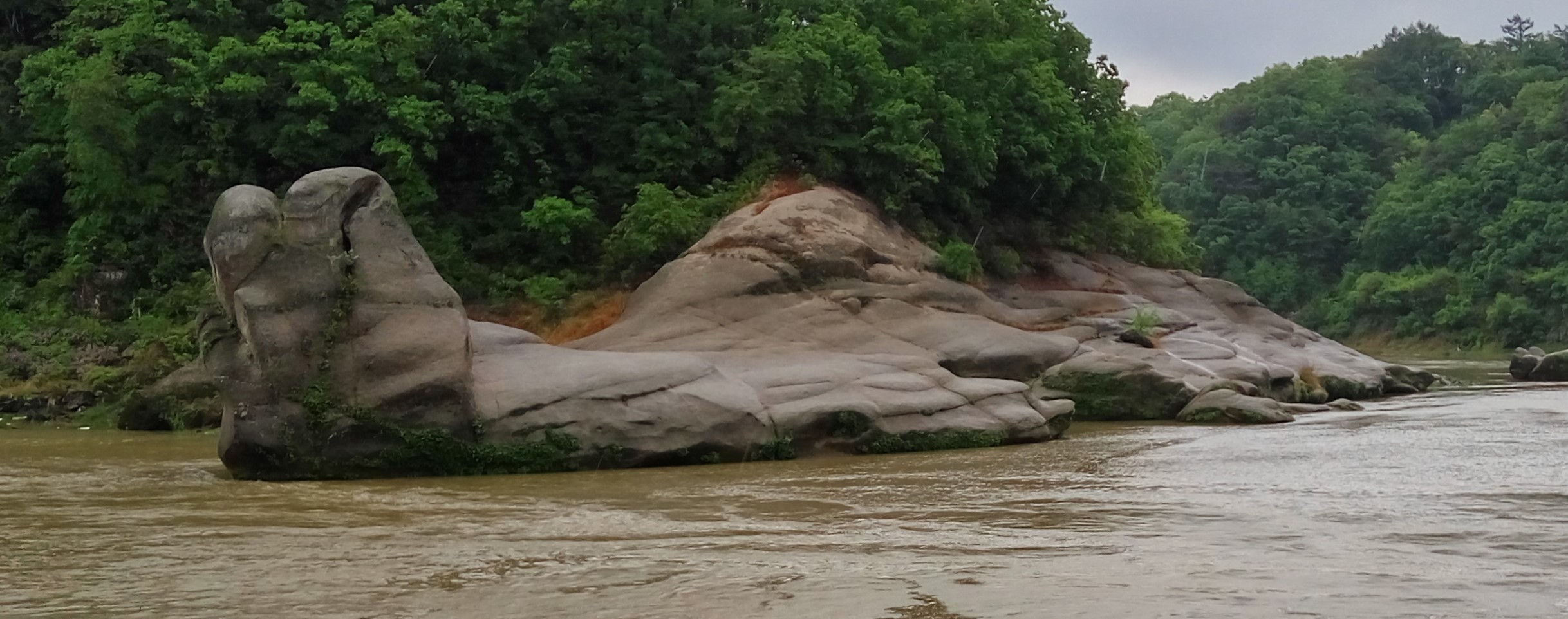
이곳의 암석은 왜 다른 곳과 달리 밝은 색을 보일까? 앞에 보이는 밝은 색의 암석은 땅속 깊은 곳에서 중생대 백악기 시대(1)에 만들어진 화강암이라는 암석입니다. 주변을 잘 관찰하면 한탄강 주변에 많이 보이는 검은색의 현무암층 아래에 있는 것을 알 수 있지요. 이는 한탄강에 용암이 흘렀을 때는 화강암 위로 흘렀다는 것을 알려줍니다. 용암이 흐른 후에 오랜 시간 (수십 만년 동안) 한탄강 물과 바람, 모래가 움직이면서 현무암은 깎여서 사라지고, 비바람에 더 잘 견디는 화강암만 남아서 지금의 모습을 가지게 되었답니다. 지금도 화적연 주변을 둘러보면 현무암이 화강암 위에 남아있는 것을 볼 수 있답니다. 화적연(禾積淵) 주변에는 화강암(화적연)을 덮은 제4기 시대의 현무암과 관입되어 나타나는 유문암, 안산암, 산성암맥 등이 관찰됩니다. 한번 찾아볼까요?
(1)중생대 백악기 시대 : 1억4500만년 전부터 신생대 팔레오세가 시작하는 6천600만년 전 사이의 시기
Why do rocks here show bright colors unlike other places? The bright-colored rock you see in front of you is a granite rock made during the Cretaceous period of the Mesozoic Era(2) deep underground. If you look around carefully, you can see that it's below the black basalt layer, which you can see a lot around Hantangang River. This tells us that lava flew over the granite when it flew into the Hantan River. After the lava flowed, the water, wind and sand of the Hantangang River moved for hundreds of thousands of years, and the basalt removed by erosion, leaving only granite that was more resistant to rain and wind. Even now, if you look around Hwajeongyeon, you can see that the black basalt remains on granite. In the vicinity of Hwajeolyun, there are basaltic rocks of the 4th period covered granite and rhyolite, andesite and acid dykes which intruded into granite. HwajeogYeon is named because granite rocks looks like a pile of rice straw. Shall we look it up?
(2)The Cretaceous period of the Mesozoic Era : From the end of the Jurassic Period 145 million years ago to the beginning of the Paleogene Period 66 million years ago
암맥은 기존 암석(모암 또는 기반암)에 갈라진 틈(fissure)으로 지하 깊은 곳의 마그마가 지표를 향해 상승하면서 들어온 화성암체를 의미합니다. 기존 암석의 갈라진 틈으로 마그마가 들어온 것을 ‘마그마가 주입되었다’, ‘관입한 마그마’라고도 표현하기도 한답니다.
A dike or dyke, in geological usage, is a sheet of rock that is formed in a fracture in a pre-existing rock body. Dikes can be either magmatic or sedimentary in origin. Magmatic dikes form when magma flows into a crack then solidifies as a sheet intrusion, either cutting across layers of rock or through a contiguous mass of rock. Clastic dikes are formed when sediment fills a pre-existing crack.
[로그하는 방법]
- (1) 이곳은 화강암에 관입하였던 유문암 암맥이다. 현재는 침식에 약한 화강암이 모두 제거되고 유문암만 남아있다. 이곳은 어디인가요? (Waypoint 1/Waypoint 2) (2) 이곳에서 암맥의 가장 넓은 부분은 ( )cm 정도이다. (3) 이곳 유문암의 색상, 질감에 대해 묘사하세요.
- (1) 이곳은 화강암을 덮고 있던 현무암의 침식이 진행되는 곳입니다. 이곳은 어디인가요? (Waypoint 1/Waypoint 2) (2) 이곳의 현무암의 형태는 주상절리이다. (진실/오류) (3) 이곳 현무암의 색상, 질감에 대해 묘사하세요.
- Waypoint 1과 Waypoint 2 사이에는 어떤 종류의 암석이 있습니까? 이 암석은 왜 이곳에 있을까요?
- Waypoint 2에서 강 건너편을 보면 어떤 지형이 보이나요?
- 화적연을 배경으로 당신 또는 당신의 GPS를 찍은 사진을 로그에 올려주세요. (선택사항이지만 사진을 올려주시기를 부탁드립니다.)
- 답을 제 Profile에 있는 메시지창을 이용해 제게 보내주세요. 이제 로그하셔도 됩니다. 답에 문제가 있을 경우 제가 메시지를 드리겠습니다.
[How to log]
- (1) This is a rhyolite dike that was intruded into granite. Currently, all eroded granites are removed and only rhyolite remains. Where is this place? (Waypoint 1/Waypoint 2) (2) The widest part of the dike here is ( ) cm. (3) Describe the color and texture of rhyolite here.
- (1) This is where erosion of the basalt that covered granite is under progress. Where is this place? (Waypoint 1/Waypoint 2) (2) The shape of the basalt here is columnar joints. (True/False) (3) Describe the color and texture of basalt here.
- What kind of rocks are there between Waypoint 1 and Waypoint 2? Why is this rock here?
- What terrain do you see when you look across the river from Waypoint 2?
- Upload the photo of you or your GPS with HwaJeogYeon at the cache zone in the background! (The task is optional but I would highly appreciate if you would do so.)
- Please send the answers to me by message on my profile! You may log as 'Found'. If the answer is not correct, I will contact you.
Ref : Pocheon City, Wikipedia