
Inquadramento geologico
Gran parte del territorio del gruppo dello Schiara è impostato su rocce di origine sedimentaria ed in particolare nella Dolomia principale del Triassico superiore che nel periodo della sua formazione costituiva una vasta piattaforma di marea (depositatasi tra i 200 e i 65 milioni di anni fa, disposta più o meno orizzontalmente con uno spessore di oltre 1000 m). Sopra la Dolomia principale poggia un'altra Dolomia più giovane e più caratteristica del gruppo: la grigia dolomia del monte Pelf, caratterizzata dall'inclusione di blocchetti spigolosi di selce. E' di solito compatta e costituisce molte vette del gruppo. Risalendo la valle dell'Ardo, a nord delle Case Bortot, invece, si trova la Formazione di Igne, come il compatto calcare oolitico del Vaiont(le ooliti sono particelle calcaree sferiche, che si accrescono concentricamente intorno ad un nucleo) e il più tenero calcare di Soccher. A partire dal Giurassico, nella porzione occidentale, la paleogeografia fu invece marcata da un alto strutturale (Piattaforma Atesina) mentre in quella orientale si instaurò un ampio e profondo bacino (Bacino Carnico-Bellunese). La struttura principale è una piega anticlinale (Anticlinale Coppolo-Pelf); questa è associata alla famiglia di faglie denominata "Linea di Belluno" che, sul versante sud, origina una morfologia complicata e di frattura. La serie stratigrafica principale è caratterizzata dalle dolomie triassiche e in particolare dalla Dolomia Principale che origina importanti cime (per esempio Schiara). Seguono, per il Giurassico, i Calcari Grigi (più o meno dolomitizzati e talvolta ricchi di fossili), e altre formazioni calcaree ricche di componenti argillosi o selciferi che assumono talvolta denominazioni locali (Rosso Ammonitico, Dolomia dello Schiara, Calcareniti della Val degli Erbandoli). Molto diffusi sono, infine, gli affioramenti del Cretacico quali Biancone e Scaglia Rossa che, nelle aree a morfologia più dolce.
Calcare verso Dolomia
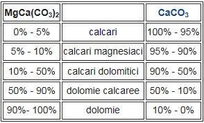
Il calcare è una roccia sedimentaria il cui componente principale è rappresentato dal minerale calcite. I giacimenti di calcare, quindi il minerale stesso, sono più o meno compenetrati da impurità argillose o quarzitiche. La calcite è un minerale spesso accoppiato alla dolomite. La dolomia è una roccia sedimentaria carbonatica costituita principalmente dal minerale dolomite, chimicamente un carbonato doppio di calcio e magnesio. Dolomia prende il suo nome (come il minerale dolomite) dal naturalista e geologo francese Déodat Gratet de Dolomieu (1750–1801), il quale osservò tale roccia nei gruppi montuosi delle Dolomiti. Quando in un calcare la calcite è parzialmente sostituita da dolomite, esso viene chiamato calcare magnesiaco, calcare dolomitico o dolomia calcarea in funzione della specie mineralogica dominante in percentuale. Nello schema seguente è riportata la classificazione completa dei termini di transizione tra dolomie e calcari:
Il metodo tradizionalmente usato per distinguere, in maniera speditiva sul terreno, nelle rocce carbonatiche fra calcare e dolomia è la prova dell'acido muriatico: una goccia di acido (diluito in acqua al 5% di concentrazione) viene versata su un campione di roccia: il calcare reagisce immediatamente esplodendo, mentre la dolomia rimane apparentemente inerte.
La durezza della roccia
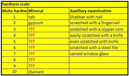
La scala di Mohs è un criterio empirico per la valutazione della durezza dei materiali. Prende il nome dal mineralogista tedesco Friedrich Mohs, che la ideò nel 1812. Essa assume come riferimento la durezza di dieci minerali numerati progressivamente da 1 a 10, tali che ciascuno è in grado di scalfire quello che lo precede ed è scalfito da quello che lo segue. Per determinare la durezza di un minerale non si fa altro che provare quale minerale della scala esso scalfisce e da quale è scalfito. Il primo minerale della serie è il talco, l'ultimo il diamante. La scala di Mohs fornisce un valore puramente indicativo della durezza, in quanto la differenza reale di durezza tra due minerali successivi varia anche notevolmente.
Per registrare questa cache è necessario portare una lente d'ingrandimento e un po 'di acido cloridrico diluito (soluzione al 10% di acido dovrebbe essere sufficiente) !!! In alternativa, puoi anche usare un acido acetico al 25% dal supermercato (aceto). Questo materiale dovrebbe funzionare
I guanti e gli occhiali di protezione devono sempre essere inclusi come dispositivi di protezione individuale. I guanti e gli occhiali di protezione devono sempre essere inclusi come dispositivi di protezione individuale. Nota: sei a tuo rischio e pericolo !!! Né io né nessun altro sarà responsabile per eventuali danni fisici che potresti subire mentre maneggi l'acido cloridrico. Se non sei sicuro, allora non fare questo Earthcache.
Per loggare questa Earthcache, andate alle coordinate indicate e rispondete alle seguenti domande. Inoltre, dovrete pubblicare con il log una vostra foto sul posto. Ovviamente, se non si vuole apparire nella foto, un oggetto personale è una prova sufficiente della vostra presenza. (Secondo le linee guida delle Earthcache, è possibile richiedereil fotolog dal giugno 2019.)
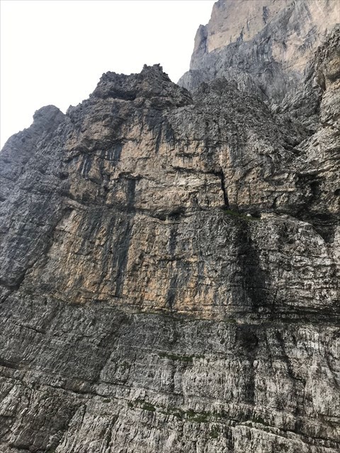
1.) WP1: Osserva attentamente la roccia e descrivi la struttura della superficie in termini di granulosità, colore e sensazione al tatto (usando la lente d'ingrandimento).
2.) WP1: Determina il grado di durezza della roccia usando la tabella qui sopra. Per questo si usa al meglio con alcuni strumenti, come ad esempio. un pezzo di legno, una moneta di rame o un coltello. Ma per favore prendi tutto con te.
3.) WP2: Ora è il momento di utilizzare l'acido cloridrico o l’acido acetico. Utilizzando gli indumenti protettivi, aggiungi una goccia al punto di rottura di un campione di pietra. Descrivi la reazione e dimmi il risultato del tuo esperimento. È un calcare o una dolomia?
Puoi loggare immediatamente. Se qualcosa non è corretto, ti contatterò.

Geologischer Rahmen
Das meiste Territorium der Schiara-Gruppe befindet sich auf Gesteinen sedimentären Ursprungs und insbesondere im Hauptdolomiten der oberen Trias, der während seiner Entstehungszeit eine riesige Gezeitenplattform darstellte (die vor 200 bis 65 Millionen Jahren abgelagert wurde und mehr angeordnet war) oder weniger horizontal mit einer Dicke von über 1000 m). Oberhalb der Hauptdolomiten liegt ein weiteres jüngeres und charakteristischeres Dolomit der Gruppe: der graue Dolomit des Mount Pelf, der durch die Einbeziehung von eckigen Feuersteinblöcken gekennzeichnet ist. Es ist in der Regel kompakt und bildet viele Spitzen der Gruppe. Das Ardo-Tal hinauf, nördlich von Case Bortot, verläuft die Igne-Formation wie der kompakte oolithische Kalkstein des Vaiont (die oolites sind kugelförmige Kalkpartikel, die konzentrisch um einen Kern wachsen) und die zartesten Kalkstein von Soccher. Ausgehend vom Jura war die Paläogeographie im westlichen Teil durch eine hohe Struktur (Atesina-Plattform) gekennzeichnet, während im östlichen Teil ein breites und tiefes Becken (Carnico-Belluno-Becken) errichtet wurde. Die Hauptstruktur ist eine antiklinale Falte (Anticlinale Coppolo-Pelf); dies hängt mit der Familie der Verwerfungen zusammen, die "Linea di Belluno" genannt wird und am Südhang zu einer komplizierten und gebrochenen Morphologie führt. Die stratigraphische Hauptserie ist geprägt von den Trias-Dolomiten und insbesondere von den Hauptdolomiten, auf denen wichtige Gipfel entstehen (z.B. Monte Schiara). Für das Jura folgen die grauen Kalksteine (mehr oder weniger dolomitiert und manchmal reich an Fossilien) und andere kalkhaltige Formationen, die reich an Ton oder selektivem Material sind und manchmal lokale Namen tragen (Ammonitrot, Dolomiten der Schiara, Calcarenites des Val degli Erbandoli). Schließlich sind die Ausläufer der Kreidezeit wie Biancone und Scaglia Rossa weit verbreitet und besitzen eine sanftere Morphologie.
Kalkstein verso Dolomit
Kalkstein ist ein Sedimentgestein, dessen Hauptbestandteil das Mineral Calcit ist. Kalkablagerungen, also das Mineral selbst, sind mehr oder weniger von Lehm- oder Quarzitverunreinigungen durchdrungen. Calcit ist ein Mineral, das häufig an Dolomit gebunden ist. Dolomit ist ein kohlensäurehaltiges Sedimentgestein, das hauptsächlich aus dem Dolomitmineral, chemisch einem doppelten Kalzium- und Magnesiumkarbonat besteht. Dolomit hat seinen Namen (als Dolomitmineral) von dem französischen Naturforscher und Geologen Déodat Gratet de Dolomieu (1750–1801), der dieses Gestein in den Gebirgsgruppen der Dolomiten beobachtete. Wenn in einem Kalkstein der Calcit teilweise durch Dolomit ersetzt ist, spricht man von Magnesiumkalkstein, Dolomitkalkstein oder kalkhaltigem Dolomit in Abhängigkeit vom prozentualen Anteil der vorherrschenden mineralogischen Spezies. Das folgende Diagramm zeigt die vollständige Klassifizierung der Übergangsterme zwischen Dolomiten und Kalksteinen:
Die traditionell angewandte Methode zur schnellen Unterscheidung zwischen Kalkstein und Dolomit in den Karbonatgesteinen am Boden ist der Beweis für die Salzsäure: Ein Tropfen Säure (verdünnt in Wasser mit einer Konzentration von 5%) wird auf eine Gesteinsprobe gegossen: Der Kalkstein reagiert sofort explodierend, während der Dolomit anscheinend inert bleibt.
Die Härte des Gestein
Die Mohs-Skala ist ein empirisches Kriterium zur Bewertung der Härte von Materialien. Es hat seinen Namen von dem deutschen Mineralogen Friedrich Mohs, der es 1812 erfunden hat. Als Referenz dient die Härte von zehn Mineralien, die fortlaufend von 1 bis 10 nummeriert werden, sodass jedes in der Lage ist, das Vorhergehende zu zerkratzen und das, was es ist, zu kratzen Daraus folgt. Um die Härte eines Minerals zu bestimmen, muss man nur beweisen, welches Mineral der Skala es zerkratzt und von welcher es zerkratzt wird. Das erste Mineral der Serie ist der Talk, das letzte der Diamant. Die Mohs-Skala gibt einen rein indikativen Wert für die Härte an, da der tatsächliche Unterschied in der Härte zwischen zwei aufeinanderfolgenden Mineralien ebenfalls beträchtlich variiert.
Um diesen Cache zu loggen, müsst ihr eine Lupe und etwas verdünnte Salzsäure (10%ige Säure sollte ausreichen) mitbringen !!! Alternativ könnt ihr auch eine 25%ige Essigsäure aus dem Supermarkt einsetzen. Das sollte damit auch funktionieren.
Als persönliche Schutzausrüstung sollten Schutzhandschuhe und Schutzbrille in jedem Fall dabei sein. Beachtet: Ihr handelt auf eigenes Risiko!!! Weder Ich noch sonst Jemand haftet für irgendwelche körperliche Schäden die ihr euch beim Umgang mit der Salzsäure zufügen könntet. Im Zweifel lieber bleiben lassen – Man muss ja nicht jeden loggen …
Um diesen Cache zu loggen, begib dich zu dieser Location und beantworte nachfolgende Fragen. Anschließend postet zu eurem Log bitte noch ein Foto von euch an der Location. Wenn ihr selbst nicht auf dem Foto erscheinen wollt, reicht natürlich auch ein persönlicher Gegenstand auf dem Foto als Beweis eurer Anwesenheit. (Laut Earthcache Guidelines ist die Forderung eines Fotobeweises seit Juni 2019 wieder erlaubt.)
1.) WP1: Betrachtet das Gestein aus der Nähe und beschreibe die Oberflächenstruktur in Bezug auf Körnung, Farbe und Haptik (nutzt hierzu die Lupe).
2.) WP1: Bestimme den Härtegrad des Felsens anhand der oben abgebildeten Tabelle. Dazu nehmt ihr am Besten ein paar Hilfsmittel mit, wie z.B. ein Stück Holz, eine Kupfermünze oder Messer. Aber nehmt bitte alles wieder mit.
3.) WP2: Nun kommt die Salzsäure respektive die Essigsäure zum Einsatz. Unter Beachtung der Schutzkleidung gebt ihr einen Tropfen auf die Bruchstelle einer Steinprobe. Beschreibt die Reaktion und teilt mir das Resultat eures Versuches mit. Handelt es sich hierbei um einen Kalkstein oder Dolomit?
Danach könnt Ihr sofort loggen. Wenn irgendetwas nicht in Ordnung sein sollte, melde ich mich.

Geological frame
Most of the territory of the Schiara group is located on rocks of sedimentary origin and especially in the main dolomites of the Upper Triassic, which during its formation was a huge tidal platform (deposited 200 to 65 million years ago and more in size) or less horizontal in thickness of over 1000 m). Above the main dolomites there is another younger and more characteristic dolomite of the group: the gray dolomite of Mount Pelf, which is characterized by the inclusion of angular blocks of flint. It is usually compact and forms many tops of the group. Up the Ardo Valley, north of Case Bortot, the Igne Formation runs like the compact Oolithic limestone of the Vaiont (the oolites are spherical lime particles that grow concentrically around a nucleus) and the most delicate limestone of Soccher. Starting from the Jura, the paleogeography in the western part was characterized by a high structure (Atesina platform), while in the eastern part of a wide and deep basin (Carnico-Belluno Basin) was built. The main structure is an anticline fold (anticlinic Coppolo-Pelf); this is related to the Family of Dislocations called "Linea di Belluno" which leads to a complicated and broken morphology on the southern slope. The main stratigraphic series is characterized by the Triassic Dolomites, and especially by the main dolomites, where important peaks are formed (for example, Monte Schiara). For the Jura, the gray limestones (more or less dolomitized and sometimes rich in fossils) and other calcareous formations rich in clay or selective material and sometimes bearing local names (Ammonitrot, Dolomites of the Schiara, Calcarenites of the Val degli Erbandoli). Finally, the Cretaceous foothills such as Biancone and Scaglia Rossa are widespread and have a gentler morphology.
Limestone verso Dolomites
Limestone is a sedimentary rock whose main constituent is the mineral calcite. Lime deposits, the mineral itself, are more or less permeated by clay or quartzite contamination. Calcite is a mineral that is often bound to dolomite. Dolomite is a carbonated sedimentary rock consisting mainly of dolomite mineral, chemically a double calcium and magnesium carbonate. Dolomite gets its name (as dolomite mineral) from the French naturalist and geologist Déodat Gratet de Dolomieu (1750-1801), who observed this rock in the mountain ranges of the Dolomites. If calcite is partially replaced by dolomite in a limestone, it is called magnesium limestone, dolomitic limestone or calcareous dolomite, depending on the percentage of the predominant mineralogical species. The following diagram shows the complete classification of the transition terms between Dolomites and limestones:
The traditional method used to quickly distinguish between limestone and dolomite in the carbonate rocks on the ground is the evidence of hydrochloric acid: a drop of acid (diluted in 5% water) is poured onto a rock sample: the limestone reacts instantaneously while the dolomite seems to remain inert.
The hardness of the rock
The Mohs scale is an empirical criterion for evaluating the hardness of materials. It takes its name from the German mineralogist Friedrich Mohs, who invented it in 1812. As a reference, the hardness of ten minerals is numbered consecutively from 1 to 10, so that each one is able to scratch the previous one and scratch what it is. To determine the hardness of a mineral, one only has to prove which mineral of the scale it is scratching and from which it is scratched. The first mineral in the series is talc, the last diamond. The Mohs scale gives a purely indicative value for hardness as the actual difference in hardness between two successive minerals also varies considerably.
To log this cache you need to bring a magnifying glass and a little diluted hydrochloric acid ((10% acid should be enough) !!! Alternatively, you can also use a 25% acetic acid from the supermarket. That should work with it.
Protective gloves and goggles should always be included as personal protective equipment. Protective gloves and goggles should always be included as personal protective equipment. Note: you are at your own risk !!! Neither I nor anyone else will be responsible for any physical damage you may be doing while handling the hydrochloric acid. If you are not sure, then do not do this Earthcache.
To log this Earthcache, go to this location and answer the following questions. Then post a photo of you at the location to your log. Of course, if you do not want to appear in the photo, a personal item in the photo is enough proof of your presence. (According to the Earthcache Guidelines, photo-proofing has been required since June 2019.)
1.) WP1: Look closely at the rock and describe the surface texture in terms of grain, color and feel (using the magnifying glass).
2.) WP1: Determine the degree of hardness of the rock using the table above. For this you take best with a few tools, such. a piece of wood, a copper coin or a knife. But please take everything with you.
3.) WP2: Now the hydrochloric acid or acetic acid is used. Taking the protective clothing into consideration, add a drop to the break point of a stone sample. Describe the reaction and tell me the result of your experiment. Is this a limestone or dolomite?
After that you can give your log directly. If anything is not ok, i will contact you.
l'indice delle fonti:
· Wikipedia
· Fotos intrinsecamente