
NL:
In deze nu zo rustige omgeving is het moeilijk een beeld te krijgen over de gewelddadige geschiedenis van dit gebied.
Historie.
Nog geen maand voor het einde van de Tweede Wereldoorlog werd de bemanning van een RAF Halifax Mk III bommenwerper op een missie gestuurd om wapens, munitie, voedsel en sigaretten te droppen voor het verzet in Nederland nabij het dorpje Ter Aar. Vliegen op lage hoogte om de vijandelijke radar te ontwijken, stond het gebruik van de parachutes niet toe. Boven de Amsterdamse Waterleidingduinen werd het vliegtuig geraakt door luchtafweergeschut, vloog in brand en stortte neer. Alle zes bemanningsleden kwamen om het leven en werden later herbegraven op de Nieuwe Oosterbegraafplaats in Amsterdam.
Farrow, Arthur, 35 jaar - 159981 Officier, navigator
Gillon, Archibald Gray, 19 jaar - 1822657 Sergeant, boordwerktuigkundige
Hogg, Arthur - 1672245 Sergeant, radiotelegrafist/boordschutter
Lytle, Samuel Alexander, 21 jaar - 154919 Officier, bommenrichter
Scott, John William - 170227 Officier-vlieger, gezagvoerder
Thomas, Stanley, 22 jaar - 1836816 Sergeant, boordschutter
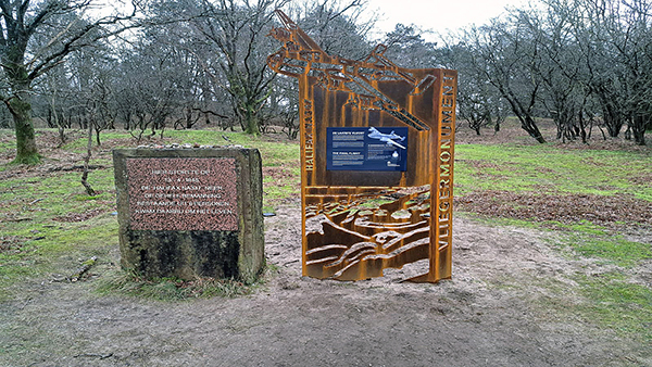
Monument.
Op de crashlocatie is een monument geplaatst voor deze tragische gebeurtenis. Sinds 1986 organiseren Waternet, de huidige eigenaar van het gebied, en basisschool De Duinroos in Zandvoort elk jaar een herdenkingsplechtigheid. Het monument staat op de locatie aangegeven door het coordinaat bovenaan de pagina en is niet het coordinaat van de cache-locatie. Ook staat naast het monument een informatiebord met details over deze laatste vlucht.
Damherten.
De Waterleidingduinen zijn bekend om hun grote hoeveelheid damherten. Geadviseerd wordt om de damherten met rust te laten vooral tijdens de bronst (voortplantingstijd) ook al houdt dit in dat de cache hierdoor niet gevonden kan worden. Het gebied is aantrekkelijk genoeg voor een tweede bezoek.
Vossen.
Ook vossen horen tot de bewoners van dit gebied en kunnen soms heel tam overkomen. Ook hier geldt, laat ze met rust en voer ze niet.
Teken.
Let op! Er zijn teken in dit gebied aanwezig. Controleer u zelf na afloop om te voorkomen dat deze kleine vrienden u en uw mede-cachers als snack gebruiken. Zij kunnen allerlei vervelende ziektes overbrengen, oa de ziekte van Lyme. Zorg dat u goede teken-tang of ander gereedschapje meeneemt om ze te verwijderen. Hoe eerder de teek verwijderd wordt hoe beter!
Benodigdheden.
Een rolmaat en een GPS met de mogelijkheid om een nieuw waypoint te projecteren tov een ander waypoint met behulp van een hoek tov true Noord en een afstand.
Tip: Omdat het projecteren van een waypoint in de meeste gevallen niet tot het standaard gebruik van een GPS behoord, kan het handig zijn om dit thuis vooraf te oefenen. Het kan in ieder geval enige frustratie voorkomen op de locatie zelf.
Cache-locatie.
Bij het monument staat een Cortenstalen constructie waarop een informatiebord is bevestigd. Meet de breedte en de hoogte van dit bord tot 0.5cm nauwkeurig.
Via een projectie moet vanaf het coordinaat bovenaan de pagina de cache-locatie bepaald worden:
- Afstand (meter) = ( Breedte x 34 ) - 1927
- Hoek (true N) = ( Hoogte x 17 ) - 514.5

Voor de Amsterdamse Waterleidingduinen geldt:
- Toegang van zonsopgang tot zonsondergang
- Toegangskaart AWD vanaf 18 jaar verplicht
- Verboden voor honden
- Verboden te fietsen
Met dank aan Waternet voor het verlenen van toestemming voor het plaatsen van de geocache!
"Laat niet als dank voor het aangenaam verpozen, de eigenaar van het bos de schillen en de dozen."

EN:
In this now peaceful environment, it is difficult to get a picture of the violent history of this area.
History.
Less than a month before the end of the Second World War, the crew of an RAF Halifax Mk III bomber was sent on a mission to drop weapons, ammunition, food and cigarettes for the resistance in the Netherlands near the village of Ter Aar. Flying at low altitude to evade enemy radar, did not allow the use of the parachutes. Over the Amsterdam Water Supply Dunes, the aircraft was hit by anti-aircraft fire, caught fire and crashed. All six crew members died and were later reburied at the New Eastern Cemetery in Amsterdam.
Farrow, Arthur, age 35 - 159981 Flying Officer, navigator
Gillon, Archibald Gray, age 19 - 1822657 Sergeant, flight engineer
Hogg, Arthur - 1672245 Sergeant, wireless operator/air gunner
Lytle, Samuel Alexander, age 21 - 154919 Flying Officer, air bomber
Scott, John William - 170227 Flying Officer, pilot
Thomas, Stanley, age 22 - 1836816 Sergeant, air gunner
Monument.
A monument has been placed for this tragic event at the crash location. Since 1986, Waternet, the current owner of the area and De Duinroos primary school in Zandvoort have been organizing a memorial ceremony every year. The monument is at the location indicated by the coordinate at the top of the page and is not the coordinate of the cache location. There is also an information board next to the monument with details about this last flight.
Fallow Deer.
The Water Supply Dunes are known for their large amount of fallow deer. It is advised to leave the fallow deer alone, especially during the rut (reproduction time), even if this means that the cache cannot be found because of this. The area is attractive enough for a second visit.
Foxes.
Foxes are also among the residents of this area and can sometimes seem very tame. Here also applies, leave them alone and do not feed them.
Ticks.
Pay attention! There are ticks in this area. Check yourself afterwards to prevent these little friends from using you and your fellow cachers as a snack. They can transfer all kinds of nasty diseases, including Lyme disease. Make sure you take good drawing pliers or other tools with you to remove them. The sooner the tick is removed, the better!
Necessities.
A tape measure and a GPS with the ability to project a new waypoint relative to another waypoint using an angle relative to true North and a distance.
Tip: Because projecting a waypoint is not part of the standard use of a GPS in most cases, it can be useful to practice this at home in advance. It can in any case prevent some frustration at the location itself.
Cache location.
At the monument there is a Corten steel construction on which an information board is attached. Measure the width and height of this sign to an accuracy of 0.5cm.
The cache location must be determined via a projection from the coordinate at the top of the page:
- Distance (meter) = ( Width x 34 ) - 1927
- Angle (true N) = ( Height x 17 ) - 514.5
The following applies to the Amsterdam Water Supply Dunes:
- Access from sunrise to sunset
- Entry card from the age of 18 compulsory
- No dogs allowed
- Forbidden to cycle
Thanks to Waternet for granting permission to install the geocache!
"Don't litter, it makes the world bitter."
Banner code:
<a href="https://coord.info/GC8B1TY"><img src="https://s3.amazonaws.com/gs-geo-images/c5031a02-649e-4b26-b086-607ba6f0c149_l.png"></a>