This cache is placed with permission and a permit (#06) available upon request. Enjoy the hunt but also remember to enjoy the journey. This is a great Ohio State Park and worth spending some time in it. This cache will be archived if proper care is not taken in the area. CITO if needed and help preserve America for our children and their future.
.
Independence Dam State Park is near the confluence of the Auglaize and Maumee Rivers. The area has played a key role in the history of Northwest Ohio, providing a travel route for numerous Indian tribes including the Iroquois, Miami, Lenape, Ottawa, Erie, Wyandot, and Shawnee. Anglo-American explorers were also drawn to the rivers for many of the same reasons as the Native Americans. It provided a reliable source of water as well as an abundance of fish and game.
Two Indian leaders spent part of their lives in the area. Pontiac, an Ottawa leader, is believed to have been born near the confluence of the rivers. He went on to lead what is known as Pontiac's Rebellion against the trade policies of the British rulers in the years following the French and Indian War. Blue Jacket, a Shawnee leader, made his home in the area. He was a leader in the Northwest Indian War, an effort to halt the westward expansion of American settlement.
President George Washington dispatched General Anthony Wayne and his men to put down the Indian uprising. After the Native Americans were driven out, the land was opened to settlement by Anglo-Americans. Homesteaders arrived soon after, cleared the land and began farming.

Independence Dam on the Maumee River
.
Independence Dam was built in the 19th century to provide water for the canal system. The original wooden dam was replaced in 1924 by the current concrete dam. At this time several civic organizations began a drive to set aside the land between the river and the canal as a state park. The Ohio Department of Public Works purchased the lands and Independence Dam State Park was opened to the public in 1949.
Independence Dam State Park is in the Maumee Valley. This valley has been changed tremendously since it was settled after the Northwest Indian War. It was in the middle of the Great Black Swamp which was 30 to 40 miles wide and about 120 miles long. It was a heavily forested area that was home to massive sycamore trees that were converted into barns and in some cases homes. Oak and tulip tress were mixed in with the sycamore and walnut.

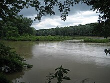
The Maumee River as seen from Independence State Park
.
Independence Dam State Park is open for year-round recreation. Access to the Maumee River is provided at the park. Unlimited horsepower boating is allowed on the river. A four-mile section above Independence Dam is open to water skiing. The river is home to northern pike, crappie, walleye, smallmouth bass, and catfish. Anglers must have a valid Ohio fishing license when fishing at the park. The former towpath for the Miami and Erie Canal is open for hiking and biking. There are several picnic tables along the banks of the river. There is a playground for the kids and plenty of grass, trees, mulberries (if you hit the right time of year) and primitive camping is available. Come and enjoy one of Ohio's great State Parks!