Questa serie di cache è dislocata lungo un percorso alpino che parte dal passo Manghen fino a raggiungere il lago delle Stellune.
E' un percorso abbastanza lungo ma con modesto dislivello, che mantenendosi sempre tra quota 2000 e 2200 metri di quota si addentra in un ambiente incontaminato caratterizzato da numerosi laghetti e ampie praterie.
L'Eterno
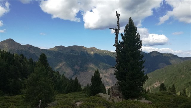
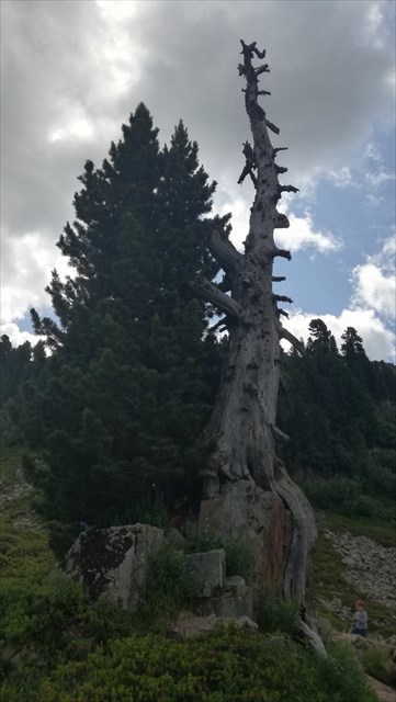
Partendo dal rifugio di passo Manghen, lungo il sentiero 322/A basso, dopo circa 30 minuti di cammino al termine della salita che porta al piano con i laghetti, si raggiunge un albero che, pur essendo morto da tempo, è stato lasciato come scultura naturale in un punto che pare fatto apposta per un monumento agli alberi. E’ l’Eterno, un Pino Cembro nato più di 1000 anni fa, di cui resta il tronco nudo e suggestivo.
La cache è nascosta proprio in prossimità di questo monumento naturale, sotto a dei sassi.
Da passo Manghen al Lago delle Stellune
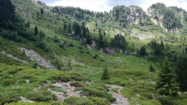
L’itinerario che conduce al Lago delle Stellune partendo da passo Manghen si sviluppa in un contesto ambientale fantastico, caratterizzato da numerosi laghetti alpini. Nella parte iniziale si transita per il solitario laghetto delle Buse, ai piedi del versante settentrionale di Cima Ziolera, mentre nella parte finale si arriva al bellissimo Lago delle Stellune alla base dell’omonimo Cimon. Il percorso si mantiene quasi sempre sopra quota 2000 e risulta abbastanza lungo pur non proponendo dislivelli impegnativi.
Dal parcheggio di Passo Manghen, si prende il sentiero SAT n.322/A che inizia dietro al Rifugio, superata una grotta adibita a cappella dedicata ai Caduti delle Guerre si prosegue giungendo all'incrocio con il sentiero 361. Da qui si segue il sentiero 322/A e 322 ricalcando una vecchia strada militare selciata, che aggira in quota il versante settentrionale del Montalon. Si prosegue fino a portarsi sotto alla Forcella del Montalon ed incrociare il sentiero 362, che collega la Val delle Stue con la Val Campelle. Di qui si segue sempre per il sentiero 322 il quale passa sopra il Pian della Maddalena giungendo poi sopra al Lago delle Stellune.
Per il ritorno, dalla forcella del Montalon è possibile seguire una variante alternativa rispetto al percorso di andata, scendendo lungo il sentiero 362 fino al laghetto del Montalon per poi seguire il sentiero 322 per risalire il versante occidentale della montagna. Si prosegue rimanendo in quota fino ad arrivare alla forcella Ziolera ed affrontare l'ultimo tratto, classificato EE, che permette di raggiungere il rifugio Manghen dal lato opposto rispetto alla partenza.
Il percorso proposto per il rientro risulta più impegnativo sia in termini di dislivello (la via d'andata risulta quasi in piano con modestio saliscendi) sia per le caratteristiche più tecniche del sentiero, che nei tratti finali è in parte attrezzato.
The trail
This series of caches is located along an alpine path that starts from Passo Manghen and reaches the Stellune lake.
It is a fairly long route but with a modest height difference. It always remains between 2000 and 2200 meters above sea level, entering an uncontaminated environment characterized by numerous small alpine lakes and wide prairies.
The Eternal
Starting from the refuge of Passo Manghen, along the path 322 / A low, after about 30 minutes of walking, after the climb that leads to the plain with the ponds, you reach a tree that, despite being long dead, was left as a natural sculpture in a point that seems made for a monument to the trees. It is the Eternal, a Pine Cembro born more than 1000 years ago, of which the bare and suggestive trunk remains.
The cache is hidden right next to this natural monument, under rocks.
From Passo Manghen to Lago delle Stellune
The itinerary that leads to Lago delle Stellune starting from Passo Manghen run in a fantastic environmental context, characterized by numerous alpine lakes. In the initial part it reach the lonely little lake of Buse, at the foot of the northern slope of Cima Ziolera, while in the final part it arrives at the beautiful Lago delle Stellune at the base of the homonymous Cimon. The route is almost always above 2000 meters and is quite long even though it does not offer challenging slopes.
From Passo Manghen car park, take the path n.322/A SAT that starts behind the hut, after passing a cave used as a chapel dedicated to the fallen of the Wars, continue to reach the intersection with path 361. From here follow the path 322/A and 322 following an old paved military road, which goes around the northern side of Montalon. Continue until you reach the Forcella del Montalon and cross path 362, which connects Val delle Stue with Val Campelle. From here follow always the path 322 which passes over the Pian della Maddalena and then reaches the Lago delle Stellune.
For the return, from the Montalon fork it is possible to follow an alternative route, descending along the path 362 up to the Montalon lake and then following the path 322 to go up the western side of the mountain. Continue to stay at a high altitude until you reach the Ziolera fork and tackle the last section, classified EE, which allows you to reach the Manghen refuge on the opposite side from the start.
The path proposed for the return is a bit more hard both in terms of difference in level (the outward route is almost level with up-and-down levels) and due to the more technical features of the path, which is partly equipped in the final sections.