☠️DGS☠️ SMEDLEY'S SUMMIT
Type:A bush walk or ride in National Park
Task:Find the camo'ed drainpipe cache
Gear:A bicycle and/or strong legs
The Area
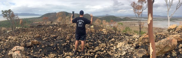
Expansive Island views, sheltered beaches bordered by rocky headlands, deep-water lagoons, seasonal wetlands and coastal woodlands all feature in this park. Mangrove-lined tributaries of the Bohle River meander across the floodplains that fill each year during the wet summer months. Up to 280 bird species have been recorded in the area. Magpie geese, brolgas and many others gather here to feed and nest, particularly as the wetlands dry out and food sources become concentrated in the remaining lagoons.
Be Prepared!
This cache is not a park and grab, it will take you on an interesting hike. Be mindful of your surroundings and always be prepared. Carry water, a first aid kit and wear suitable clothing for the environment. Above all do not take unnecessary risks, leave that to the Dirtbags.
Lets Go Get Dirty 💩
Take the dirt track leading to the Town Common Conservation Park leaving your vehicle at the Freshwater car park. From here you can choose to walk or ride approximately 4.5km along the Freshwater and Shelley Beach trails before turning left to join Smedley's trail. Here you must choose whether you take the direct route bush bashing 600m up to the cache or follow the trail to within 200m of the cache before heading off-trail. Both options are steep and will have the calves burning.
Permission
Permission has been granted by the Queensland Parks and Wildlife Services (QPWS). All standard rules and regulations must be complied with inside the National Park.
The park can be accessed at any time but please note that the gate at the Cape Pallarenda Road entrance is only open from 6.30am to 6.30pm daily. See the related page for more details regarding the area and the trails map and click here for NPWS Alerts.
I look forward to reading about your journey. Please post some pictures.
 Adventure is out there
Cheers
The Dirtbags Downunder
 Dirtbag Badge of Honour
When you have logged 5 or more Dirtbag Geocaching Townsville hides, you may display this badge on your profile using the HTML code below:
<a href="https://www.geocaching.com/plan/lists/BM7W852" ><img src="https://s3.amazonaws.com/gs-geo-images/aafacbe2-5211-4144-8635-81b7b862b237.jpg" /></a>
Congratulations to BenM70 for being the FTF.