A bluff is a type rounded cliff that is quite broad. Most bluffs border a beach, river, or other coastal area.
Bluffs may form along a river where it twist, turns, curves, or meanders from side to side. River currents on the outside of the curve erode and eat away the lower part of a river bank. When there is no more support, the upper part of the bank breaks off, leaving the high wall of a bluff. The 150-metre Great River Bluffs in the state of Minnesota, were carved by the meanderings of the Mississippi River.
Erosion also produces bluffs beside the flood plain of a river. Over thousands of years, a meandering river gradually moves from side to side across its flood plain. Where the river meanders, or loops, and comes in contact with river valley walls, the water may carve bluffs. In fact, a bluff lines mark the boundry of the outer limits of a river’s flood plain, and is often another name for the wall of a valley. A flood plain’s bluff lines may be narrow and steep, or they may be gentle and wide.
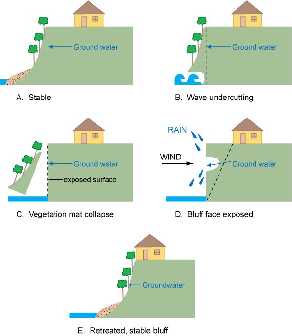
Bluff erosion simulation

Coastal bluffs are formed through a combination of erosion from wind, sea spray, and crashing waves. These bluffs are often more rugged than their inland counterparts, and are more vulnerable to major erosion. Coastal bluffs, are sometimes called feeder bluffs. The constant erosion of feeder bluffs supplies sediment to the seashore and beaches.

Another kind of coastal bluff is the beach ridge. Beach ridges are formed entirely by waves crashing onshore. the waves laping on shore push sand and sediment up and away from the body of water. Beach ridges run parallel to the shoreline and are often associated with sand dunes. The Indiana Dunes, are beach dunes which are extensions of beach ridges formed by the waters of Lake Michigan. At this national lakeshore, tiny bluffs give way to larger dunes, and the ecosystem creates the ideal conditions for an Oak forest through the process of plant succession.

Like many types of cliffs, bluffs contain important information about how Earth developed. The exposed rock of scots bluff allows geologists toblook more than 30 million years into North America’s past. Rock formations at Scotts Bluff preserve the history of ancient volcanic activity nearby, they also prezerve the fossilized presence of prehistoric North American animals. Some of these animals inclde camels, tapirs, and even rhinos. The bluffs here at mackinac preserve information about lake Hurons water levels in the past.

To log this earth cache:
1.Do you think that the mackinac island bluffs are costal or beach bluffs. Why?
2. Explain in your own words how these bluffs were formed.
3. Can you see any signs of erosion on the bluff. If yes on what Part of the bluff?
4. Is this bluff a feeder bluff. Why?
This Is my first earthcache and I hope it is a good one.
Sources:https://www.nationalgeographic.org/encyclopedia/bluff/, https://geography.wisc.edu/coastal/viz3d/

