About SideTracked Caches
This geocache belongs to the SideTracked series that is popular in the UK and throughout the world. The first cache was placed on the 10th August, 2007, and is now spreading around the world. It is designed to be a relatively quick cache find around train stations for travellers but, of course, anyone else can find it too! More Information about the series can be found at the SideTracked Series
Please bring your own writing stick to sign the log and remember if you have not signed the log you have not officially found the cache.
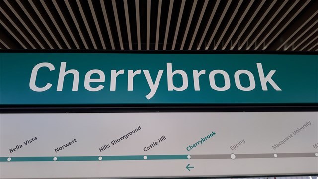
Cherrybrook
The area was originally orchards and the name comes from a 65 acre farm nearby which grew cherries amongst other fruits along the creek. It is believed to be the only farm to grow cherries and so became known as “Cherrybrook”. This name was adopted for the new suburb land release in the northern part of West Pennant Hills in 1978.
The local area also has two great tourist spots, Koala Park and the Cumberland State Forest which is one of only a few remaining locations in Sydney where you can see the bushland as it originally was before the First Settlement of Sydney by Europeans in 1788.
Interestingly the land for the Cumberland State Forest was set aside by the NSW government in 1939 as it was an undeveloped pristine area of typical Sydney bushland and was to be near the newly proposed railway line and station to be built, ‘so people could travel by train to the area and enjoy a day in the bushland’. Unfortunately it took another 80 years for the project to be completed!
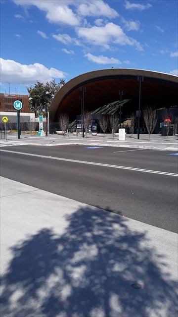
About Cherrybrook Station
The station is an open cut station located between Castle Hill Road and Bradfield Parade, a new street which was created for the Metro project. This means the station is open to the skies, with a canopy providing shade and cover to parts of the platforms whilst maximising the daylight and natural ventilation. The station is approximately seven metres below street level.
In the original proposal for the North West Metro there were to be two stations in the West Pennant Hills area, one at Highs Road and one near Koala Park and the Cumberland State Forest, but in the final plan only one station was constructed, roughly halfway between the two initial sites and named Franklin Road. The name was changed to Cherrybrook in 2013 in the final proposal for the Metro, although geographically the station is technically in West Pennant Hills.
It is anticipated that in the future the area will be developed into a small retail precinct with open space for commuters and local residents to enjoy.
Distance: 19 kilometres from Chatswood
Opened: 26th May 2019
Travel time: 21 minutes
Although there is a parking station attached to this station rumour has it that it is full by about 7am. There is no pick up/ drop off parking at this station so street parking may be your only option if you do not come here by the Metro.