|
Many active, dormant and extinct African volcanoes are like the pearls of a necklace located along the Great Rift Valley, an active rift which almost splits Africa in half.
It's in the mid position of this rift-system, near lake Kivu, that the most active and dangerous African volcanoes can be found, the Nyiragongo (3.469m) and the Nyamuragira (3.085m). The Nyamuragira erupted between 1894 and 1979 for fifteen times (and is still active) forming large lava-streams (well recognizable on satellite imagines), however not affecing a densely populated area. In contrast the last eruption of the Nyiragongo in the Democratic Republic of Congo in January 2002 killed more than 100 people and caused great havoc in the nearby city of Goma - a foreseen catastrophe.
Welcome to AGT's most dangerous cache.
GEOLOGY
Mount Nyiragongo is an active strato-volcano with an elevation of 3470 m (11382 ft) in the Virunga Mountains associated with the Albertine Rift. Located inside Virunga National Park, in the Democratic Republic of the Congo, about 20 km (12 mi) north from the town of Goma and Lake Kivu and just west of the border with Rwanda.
The main crater is about two kilometers wide and usually contains a Lava Lake. The crater presently has two distinct cooled lava benches within the crater walls – one at about 3,175 metres (10,417 ft) and a lower one at about 2,975 m (9,760 ft).
Nyiragongo’s Lava Lake has at times been the most voluminous known Lava Lake in recent history. The depth of the Lava Lake varies considerably.
A maximum elevation of the Lava Lake was recorded at about 3,250 m (10,660 ft) prior to the January 1977 eruption – a Lake depth of about 600 m (2,000 ft). A recent very low elevation of the Lava Lake was recorded at about 2,700 m (8,900 ft). Nyiragongo and nearby Nyamuragira are together responsible for 40% of Africa’s historical volcanic eruptions.
Magma Plumbing System
The magmatic system of Nyiragongo remains poorly constrained. The currently best model for the magma plumbing system of Nyiragongo is composed by two crustal chambers located at depths of 10-14 km and 1-4 km beneath the main edifice, being fed by an 80-150 km deep mantle source.

The shallow magma chamber is likely directly connected to the lava lake located in the main crater, explaining the persistence of the lava lake activity. Results from recent seismic and ground deformation studies of the Nyiragongo 2002 eruption are consistent with this 2-chamber model.
Mount Nyamuragira is located in left and Nyiragongo in the right of Virunga National Park. Not much is known about how long the volcano has been erupting, but since 1882, it has erupted at least 34 times, including many periods where activity was continuous for years at a time, often in the form of a churning Lava Lake in the crater.
The volcano partly overlaps with two older Volcanoes, Baratu and Shaheru, and is also surrounded by hundreds of small volcanic cinder cones from flank eruptions.
Volcanism at Nyiragongo is caused by the rifting of the Earth’s crust where two parts of the African Plate are breaking apart. A hot spot is probably also partly responsible for the great activity at Nyiragongo and Nyamuragira.

The Lava emitted in eruptions at Nyiragongo is often unusually fluid. Nyiragongo’s Lava’s are made of melilite nephelinite, an alkali-rich type of volcanic rock whose unusual chemical composition may be a factor in the unusual fluidity of the Lava’s there.
Whereas most Lava flows move rather slowly and rarely pose a danger to human life, Nyiragongo’s Lava flows may race downhill at up to 60 miles per hour (up to 100 km/h). This is because of the extremely low silica content (the lava is mafic).
Hawaiian volcanic eruptions are also characterized by Lava’s with low silica content, but the Hawaiian volcanoes are broad, shallow-sloped shield volcanoes in contrast to the steep-sided cone of Nyiragongo, and the silica content is high enough to slow most Hawaiian flows to walking pace.
The Lava Lake activity continued through 2010. At present, the Lake is mostly confined within a broad, steep-sided cinder cone on the crater floor, roughly 60 feet high by 600 feet wide.
Between 1894 and 1977 the crater contained an active Lava Lake. On 10 January 1977, the crater walls fractured, and the Lava Lake drained in less than an hour. The Lava flowed down the flanks of the volcano at speeds of up to 60 miles per hour on the upper slopes, overwhelming villages and killing at least 70 people.
The hazards posed by eruptions like this are unique to Nyiragongo. Nowhere else in the world does such a steep-sided strato volcano contain a Lake of such fluid Lava. Nyiragongo’s proximity to heavily populated areas increases its potential for causing a natural disaster.
The 1977 eruption raised awareness of the unique dangers posed by Nyiragongo, and because of this it was designated a Decade Volcano, worthy of particular study, in 1991.
The 1977 eruption was preceded by the creation of a new small volcano, Murara, a short distance away on the slopes of Nyamuragira.Lava Lakes reformed in the crater in eruptions in 1982–1983 and 1994. Another major eruption of the volcano began on January 17, 2002, after several months of increased seismic and fumarolic activity.
|
|
About 147 people died in the eruption from asphyxiation by carbon dioxide and buildings collapsing due to the lava and earthquakes. At least 15% of Goma comprising 4,500 buildings were destroyed, leaving about 120,000 people homeless.
Immediately after the eruption stopped, a large number of earthquakes were felt around Goma and Gisenyi. This swarm activity continued for about three months and caused the collapse of more buildings.Six months after the start of the 2002 eruption, Nyiragongo volcano erupted again.
Activity at Nyiragongo is ongoing, but currently confined to the crater, where another Lava Lake has formed about 250 metres below the level of the 1994 Lava Lake.
Localized carbon dioxide toxicity, known locally as ‘mazuku’, has killed children even more recently. In locations where the gas seeps from the ground in relatively high levels, without the dispersing effects of wind, its effects can be deadly.
Volcanic Edifice and Lava Field
The volcanic field of Nyiragongo is surrounded by the volcanic fields of Nyamulagira (in the north and west), Karisimbi and Mikeno volcanoes (in the east), and by Lake Kivu on its southern side. The volcanic field of Nyiragongo also extends southward, in the northern basin of Lake Kivu. At the ground surface, the volcanic field is characterized by several magmatic and phreatomagmatic cones and, in its northern part, by the main volcanic edifice.

Location map of the Nyiragongo lava field. (a) Map showing the location of the Virunga Volcanic Province (red triangle) in eastern Africa. Black lineaments represent the main fault escarpments of the East African Rift System. (b) Location of Nyiragongo (red triangle) and its lava field in the Virunga Volcanic Province. The light red surface in the map is the Virunga volcanic field. The more intense red area is the Nyiragongo lava field. Black triangles represent the 7 other main volcanic edifices of the Virunga. The background image is a slope image derived from the SRTM-1 DEM (NGA/NASA; Farr et al., 2007). In this background image, the darker the area, the steepest the slopes.
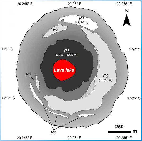
The Nyiragongo main crater is charecterized by platforms attached to its inner flanks, which correspond to the former lava lake levels reached before the 1977 and 2002 flank eruptions. The upper platform P1 is the uppermost lava lake level reached in April 1972. Platform P2, which is the larget platform in the crater, represents the last level reached by the lava lake in December 1995 until its drainage in 2002. P2 is located ~230 m below the crater rim. Platform P3 corresponds to the crater’s floor where the lava lake is located. It is characterized by outward-dipping gentle slopes surrounding the pit where the lava lake is located.
Important information
This cache is really very demanding. If you have no experience with visiting active volcanoes, I recommend that you consider your visit carefully. In any case, I recommend you to help the agency, which will arrange a trip to the volcano. The whole journey takes 7 - 8 hours walking (even longer depending on your fitness).
The weather definitely changes and put on your warm attires and please DO NOT FORGET to come with good hiking shoes, hand gloves and cap and camera.
Before ascent, check the current volcano activity.
|
|