
The Tuia Mātauranga GeoTour is about having fun discovering the history of Aotearoa New Zealand by finding sites of significance in local communities from early Pacific voyaging and migration, European settlement to present day. The interaction between people, and people and the land have provided a rich history that the GeoTour invites you to explore.
---
Pre-European Māori society was characterised by change through migration, wars, alliances, politics, responses to natural resource use and numerous other factors. The boundaries between the tribes were rarely stable and constant. Territories expanded or shrunk with the fortunes of war.
In Thames the Ngāti Huarere people were overwhelmed and displaced by the Marutuahu tribes of the Tainui Waka in the years 1500-1600. Tribes descendant from Marutuahu still occupy the area today. These tribes – Ngāti Tamatera, Ngāti Paoa, Ngāti Whanaunga and Ngāti Maru – each occupied many locations in the region rather than exclusive areas.
The original name of Thames township was Te Kauaeranga meaning “the stacked row of jawbones”. Originally this referred to whale jawbones. The region provided many natural resources and made the Thames area a good place for early Māori settlement.
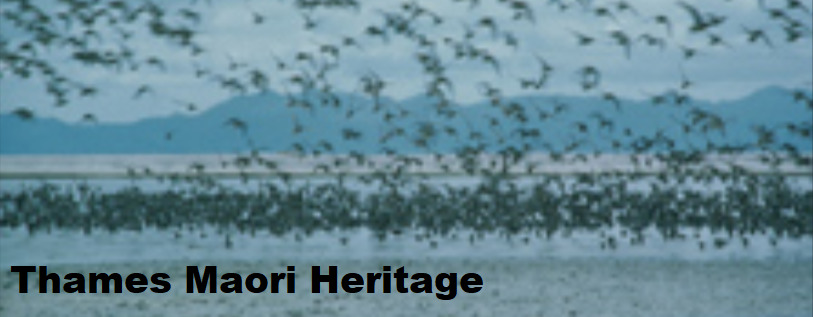
The coastline, mudflats and sea (Tikapa Moana), was an abundant resource of fish and shellfish. The river systems of Kauaeranga, Waihou and Piako provided eels and other fish. The river and wetland bird species together with the coastal migratory birds were well known and extensively harvested.
The alluvial flats, adjacent to the many streams, and extending into the small valleys were cultivated and were sites for small houses and nohonga pā (everyday dwelling places). The hills and ridges surrounding Thames offered locations for important, defensive, strongly constructed pā and were also used in peacetime along with those on the flats.
The Ngāti Huarere in the mid 1600s had a network of twenty-one pā in the general Thames-Kopu area. Some were taken over by conquest and settled by Marutuahu tribes in the early 17th century. Their dominance continued and they were the tangata whenua by the time the early Europeans arrived in Thames in the mid 1830s.
The first European visitor to the area after Cook, Captain Dell on the ship The Fancy which spent 3 months in the Waihou River area in 1794, recorded a large population in the Waihou area: villages on both sides of the river and several large pā on the banks. On one occasion Dell described 117 canoes surrounding the ship and 1500–2000 people gathered.
By the mid and late 1800s there was strong interaction in trade and commerce. The Thames iwi had extensive cultivations and farms supplying food and provisions to the Auckland market (by sea) and to the expanding European population in this region.
The discovery of gold in Thames in 1867 led to a rapid development of Māori land, and changed the face of Māori society. Some of the local chiefs signed goldfields agreements with Governor Grey to permit goldmining in the hills around Thames, but others resisted mining on their land.
There are many Māori heritage sites around Thames including pā sites, urupa, Parawai (rich alluvial flats), churches and other buildings, and the foreshore and mudflats. Many street names are named after aspects of Maori heritage: Hape (a chief), Hauraki (north wind), Herewaka (canoe mooring), Parawai, Maramarahi (full moon), Tui, Karaka, Tararau, Waikiekie (weaving flax stream).
The cache is hidden along the foreshore at Thames. Standing at this heritage site if you look to the hills behind you, you will see another heritage site – Tutukaka Pā, easily located by the Thames War Memorial Monument on the ridge.
---
To be able to complete this Geotour and receive your special geocoin, remember to take a note of the codeword on the log book of the cache. This will need to be recorded in your passport which can be downloaded from here. If the passport is unavailable for any reason just keep a note of the codeword and try again later.