
The Tuia Mātauranga GeoTour is about having fun discovering the history of Aotearoa New Zealand by finding sites of significance in local communities from early Pacific voyaging and migration, European settlement to present day. The interaction between people, and people and the land have provided a rich history that the GeoTour invites you to explore.
---
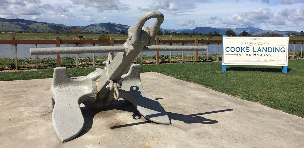
The Captain Cook Memorial and Picnic Area is situated on the western bank of the Waihou River. A steel ship’s anchor donated by the Royal Navy of New Zealand serves as a symbolic recognition of the exploits of Lieutenant James Cook on his voyage in the Coromandel Hauraki area in November 1769. Information boards about the Waihou River tell of the river’s history and Lieutenant Cook’s experience of the area.
Cook’s Landing is significant because it was where, on 20 November 1769, James Cook and his men including the great Tahitian navigator and translator Tupaia, botanist Joseph Banks and scientist/artist Daniel Solander came ashore, after making a journey 12 -14 nautical miles upriver on two long boats in search of timber suitable for masts and spars for the Admiralty. Their ship Endeavour was anchored off Te Puru, 9 nautical miles from the river mouth. This was the longest trip Cook ever took from the Endeavour, and the furthest inland he ever travelled or charted.
The local Māori had heard about Cook, and when their boats reached the shores of the Ōruarangi Pā, 3.2 miles from the river mouth, Cook describes how the people flocked to the banks to meet them and invited them ashore. After a short visit and some trading they continued to explore upstream.
Cook showed great admiration for the area, naming the river ‘Thames’, as it reminded him of Thames in England. When the river continued to meander ahead without any sign of ending, Cook and his party came ashore on the western side of the river. Here they explored the thick forest of lofty kahikatea rising up from the swampy banks and took precise measurements of a good sized tree. Cook and his carpenter recognised these ‘white pine’ as an important source of mast timber.
In 1769 the catchment was in a natural state with kahikatea forest lining the riverbank. Ships started taking logs from Hikutaia just 24 years after Cook landed there, with an information board at the memorial detailing the ships and number of logs (in their hundreds) that were taken between 1794 and 1920. By 1900 gold mining was at its peak, forest clearing had started and farming was beginning. Today the Waihou River is stopbanked and the fertile Hauraki plain extensively drained. Dairy farming replaced most of the forest. The river kept its name ‘Thames’ until 1928 when it reverted back to ‘Waihou’. During the 1860’s gold rush times the Hauraki - Coromandel area became known as 'The Thames', as a result of Cook's legacy.
To work out the coordinates for the cache, find the board to the right of the steps displaying information on the first log-carrying ships. The Final is a short drive away at one of the possible Cook landing sites at S37 18.ABC E175 36.XYZ
A How many years were there between the first ship and the EL. Pummier?
B How many different ships are listed?
C How many logs did the Royal Admiral carry? Use the last digit.
X How long after Cook’s visit did the first log ships arrive? Use the last digit.
Y How many logs were loaded on The Fancy. Take the sum of the digits.
Z When was The Hunter’s first shipment? Use the last digit
Check-sum A + B + C + X + Y + Z = 35
---
To be able to complete this Geotour and receive your special geocoin, remember to take a note of the codeword on the log book of the cache. This will need to be recorded in your passport which can be downloaded from here. If the passport is unavailable for any reason just keep a note of the codeword and try again later.