The Tuia Mātauranga GeoTour is about having fun discovering the history of Aotearoa New Zealand by finding sites of significance in local communities.
Isolated for millions of years, this country developed into a beautiful archipelago with beaches, rivers and lakes, mountains and plains. Eighty five per cent of the native animals and plants are unique to this land. A land rich in resources.
New Zealand has a history of exploration, voyaging and migration. Many generations ago the exceptional feats of Pacific voyagers, using traditional skills and knowledge, crossed Te Moana-nui-a-Kiwa (the Pacific Ocean) to settle here.
In 1769 the Endeavour navigated by Lieutenant James Cook and Tahitian high priest Tupaia reached New Zealand shores. The interaction between people, and people and the land, have provided a rich history that the GeoTour invites you to explore.
The theme of this cache is Colonialism
Mangamaunu is an area of extreme significance to Te Runanga o Kaikōura. Known as Kaiwhare, or ‘food bowl’, it was treasured for its bountiful supply of food from both the land and sea. The land held additional value because the coastal area contained burial caves, pā settlements and cultivation areas atop the terraces.
In 1859, James Mackay, the assistant native secretary acting on behalf of the Crown, negotiated with Ngāti Kuri to purchase the Kaikōura district. Mackay offered £200 for the purchase, but Ngāti Kuri asked for £5000 instead. Sensing a potential issue, as unbeknownst to Ngāti Kuri some tracts of land had already been sold to European settlers, Mackay increased his offer to £300, and Ngāti Kuri agreed to the sale. This agreement became known as the Kaikōura Deed of Purchase and permitted the Crown to take ownership of the land between Cape Campbell in the north, to the Hurunui River in the south, a total area of approximately 2.5 million acres for the bargain price of £300.
Several parcels of land were excluded from the Kaikōura Deed of Purchase because they had sacred value to Ngāti Kuri, or were important food gathering areas, or because they were the location of existing Māori settlements. These areas became known as Native Reserves and Mangamaunu, at 4,800 acres, was quite possibly the largest Native Reserve in the South Island.
In 1908, local historian W.J. Elvy quizzed Māori about why they had chosen to keep this area with its rough terrain, rather than occupy the grass covered lands of Kaikōura Flat. A local Māori simply answered, “when the pākehā came the Māori knew nothing of the cow and the sheep. He only knew the foods of the forest and the sea.” Māori simply had no concept of agriculture and livestock, as there were no such animals in New Zealand prior to European arrival. The sea was the great food resource with plentiful supplies of fish and shellfish, including pāua and kōura (crayfish), indeed it was once one of the richest food resources to be found in New Zealand. Karaka berries grew in groves, the forests were teeming with birds, and the kūmara was cultivated in gardens above the terraces.
At the time, Māori also had no understanding of the European concept of land ownership. Raised in a culture that saw land as being for communal use, they had difficulty understanding the desire to fence off land for personal use, and to forbid entry to lands that had once been freely crossed for hunting and travel.
Mangamaunu Reserve extended north taking in Parikarangaranga Pā, Mangamaunu Pā and Waimangarara Pā which are situated on the terrace edge. Towards the south the block terminated at Hapuku River and included the Mangamaunu flat settlement, also known as Kainga Flat (Figure 1), as well as the terrace settlement, which was located across the road from the cache location. There are still houses on the flat, but the Kainga no longer exists. The terrace settlement is no longer occupied and near the turn of the twentieth century became the site of Mangamaunu Marae. In 1890, Māori elders gifted part of the land on the terrace to the Catholic Church as a reserve, and subsequently St Francis church was erected on the site. In addition to the church a wharenui (meeting house) was erected at the same time. The wharenui was named Hohepa in 1915 after the death of the Maori acolyte by the same name. Hohepa was a resident of Kaikoura at the time of Te Rauparaha's raid in 1828 and was captured and taken north to Kapiti Island to serve as a slave. There he discovered Catholicism, and upon his release from captivity, he returned to Kaikoura and brought Catholicism to Kaikōura Māori, so they named the wharenui in his honour (Figure 2).

Figure 1: Mangamaunu Flat settlement, nalso known as Kainga Flat c.1890
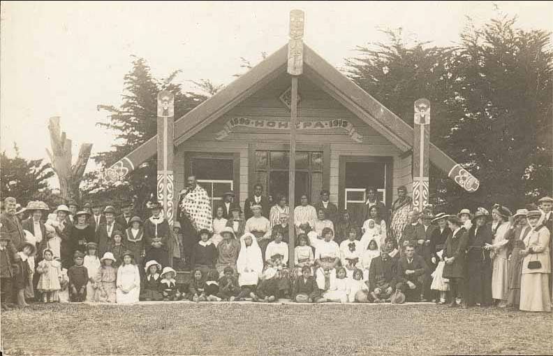
Figure 2: Hohepa Wharenui at Mangamaunu Marae c.1915
What can you see from GZ?
Looking north you can see Mangamaunu with its popular surf break. The terrace directly to the north, looming above State Highway 1, was once a cultivation and habitation area, with three terrace edge pā situated at intervals up the coast. The driveway that can be seen going up to the terrace top leads to Mangamaunu Marae and St Francis Church. To the south-west of the cache location is the Mangamaunu Māori urupā, Pohanui umu Wheke, which is an important burial ground. Kiwa Road heads south towards the former Mangamaunu flat settlement.
The cache is located beside a parking area. It can be busy at times, but you should be able to access the cache without gaining much attention. Please note; the cache is located near a railway track which is used several times a day, please keep a close eye on children and don't let them go near the tracks. Also note that Mangamaunu Marae is not open to the public unless prior arrangements have been made. The urupa is open to the public but please avoid entering if there are any events taking place. Feel free to explore the beach and take in the views.
Further Information
If you wish to learn more about the history of Kaikoura there are a number of very good books available including; 'Kaikoura: A History of the District' by J.M. Sherrard and W.J. Elvy's 'Kaikoura Coast; the history, traditions and Maori place names of Kaikoura'. If you would like a more visual lesson than you can always visit Kaikoura Museum.
To complete this Geotour and receive your special geocoin, remember to take note of the codeword on the log book of the cache. This will need to be recorded in your passport which can be downloaded from here. If the passport is unavailable for any reason just keep a note of the codeword and try again later.