
The Tuia Mātauranga GeoTour is about having fun discovering the history of Aotearoa New Zealand by finding sites of significance in local communities from early Pacific voyaging and migration, European settlement to present day. The interaction between people, and people and the land have provided a rich history that the GeoTour invites you to explore.
---
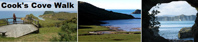
Cooks Cove Walkway is situated North of Gisborne at the southern end of Tolaga Bay. The walk is 5.8km return and takes about 2 ½ hours. It is suitable for medium levels of fitness. A visit to the Hole-in-the-Wall is well worthwhile. A shorter 20 minute walk takes you to a lookout point which gives the first views of Cook’s Cove itself. Information panels along this walkway tell the story of Captain James Cook and the crew of the Endeavour’s visit to Cook’s Cove (Opoutama), the Māori history of local iwi Te Aitanga-a-Hauiti, and the excavation of an archaeological site at Opoutama first occupied by Māori.
The walkway is named after the cove and Captain James Cook who visited the area in 1769 as part of his circumnavigation of New Zealand. At that time the Tolaga Bay area had already been inhabited by Māori for many centuries. The main iwi (tribe) living at the bay and using Cook’s Cove for fishing and gathering other seafood was Te Aitanga-a-Hauiti, who made their homes around the rich, coastal land of Tolaga Bay and the alluvial flats of the Uawa and Mangaheia rivers. There were large cultivations on the flats surrounding the low hills, and pā (fortified villages) on prominent ridges and high points, both inland and along the coast itself. An estimate of the early population of Tolaga Bay is 1,200 people, a significant number at that time.
When James Cook's vessel, the Endeavour, first approached Tolaga Bay, he had already spent two-and-a-half weeks exploring the New Zealand coastline. He reached Poverty Bay in early October 1769, after a journey of more than a year, from Plymouth Sound, England, via Tahiti. Along with this crew he made a number of records of what he saw, providing us with an interesting picture of the past. As the Endeavour anchored in Tolaga Bay, a number of canoes came alongside bringing the crew fish and kumara. There was a great deal of contact between the locals and the visitors while the ship was anchored in the bay.
One of the crew (Sydney Parkinson) described the country as ‘agreeable beyond description’ and Joseph Banks, the botanist on board, collected 20 new plant species, some of which the crew sampled. The Tahitian high priest Tupaia, who travelled on board the Endeavour, spent time in discussions with local priests (tohunga) and appears to have made a deep impression as several places were named after him. The crew of the Endeavour spent time at the place now known as Cook’s Cove (Opoutama) where they dug a well to collect fresh water. They were also much taken with the Hole-in-theWall rock formation. The visitors were received with warm and friendly support and the crew's overall impressions of the bay were extremely positive.
Banks wrote: ‘Throughout all this District the people seem free from apprehension and as in a state of Profound Peace; their Cultivations were far more numerous and larger than we saw them anywhere else, and they had a far greater quantity of fine Boats, fine Cloaths, fine carved work; in short the People were far more numerous, and lived in much greater affluence than any others we saw’.
Cook weighed anchor and left Tolaga Bay on the morning of Sunday 29 October 1769, after taking on supplies of wood, water and food. The Endeavour visit was well remembered by the different hapū (sub-tribes) of Te Aitangaa-Hauiti, and there are various accounts describing the kinds of goods that the local people acquired from Cook and the effect that they had on the local economy.
The cache is a 200ml sistema located at the trailhead to the scenic Cook’s Cove walkway, and is accessible without entering the carpark which is locked during lambing.
NOTE: This walkway is closed each year for the lambing season from 1 August until the start of Labour Weekend (fourth Monday in October). The use of this walkway has been made possible through the generous permission of the landowners, Hauiti Incorporation.
---
To be able to complete this Geotour and receive your special geocoin, remember to take a note of the codeword on the log book of the cache. This will need to be recorded in your passport which can be downloaded from here. If the passport is unavailable for any reason just keep a note of the codeword and try again later.
.