
The Tuia Mātauranga GeoTour is about having fun discovering the history of Aotearoa New Zealand by finding sites of significance in local communities from early Pacific voyaging and migration, European settlement to present day. The interaction between people, and people and the land have provided a rich history that the GeoTour invites you to explore.
---
“The foreshore of the Turanganui River is one of the world’s great voyaging sites. It is the landing place of the Horouta canoe, celebrating the achievements of the Polynesian star navigators. It is the place where Captain James Cook and his companions first came ashore in New Zealand, heralding the traditions of European exploration and discovery.
It is the site where Tupaea, the Ra’iatean high priest navigator who sailed with Cook, first met Maori, marking the links between local people and their ancestral homelands. It is a meeting place of cultures, of challenges and shootings, as well as friendly exchanges. Here Captain Cook and a local man saluted each other with a hongi on Te Toka a Taiau – the first greeting between a Maori and a European.
It is a sacred site for all New Zealanders, to be celebrated with pride and treated with dignity.”
- Dame Anne Salmond Chairperson New Zealand Historic Places Trust
Māori oral histories were passed down from generation to generation through whakapapa, whakataukī, korero and waiata (lineage, sayings, meetings, and songs). We know about the earliest arrivals from these stories; the canoe traditions contain both symbolic and historical elements. Tradition holds that Nukutaimemeha, the waka that Māui used to haul up the North Island, rests petrified on Hikurangi mountain. Paikea travelled to Aotearoa from Hawaiki on the back of a whale and landed at Whāngārā. According to some tribal narratives, Kupe was the first Polynesian to discover the islands of New Zealand. Toi is one of the best known of the traditional Māori canoe voyagers from Hawaiki, and one of the earliest.
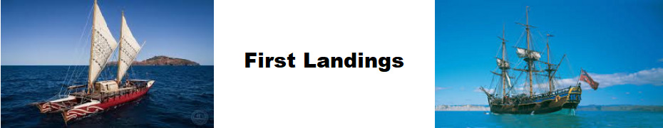
The first settlers to Tairāwhiti Gisborne arrived around 1350 in traditional Pacific double-hulled canoes (waka hourua). These were navigated using ancient wayfinding skills that required vast knowledge of the movement of the sun, the moon, the stars, the waves, the currents, the winds, clouds and birds.
The sacred Tākitimu waka landed at Whangaōkena (East Cape), Ūawa (Tolaga Bay), Tūranganui (Gisborne), Nukutaurua (on Māhia Peninsula) and other points further south along the east coast.
The Horouta waka was captained by Kiwa and Pāoa. It made landfall at Ōhiwa after its prow (haumi) was damaged. Pāoa travelled inland, locating timber to repair the prow on a mountain, hence the name Maungahaumi. Horouta was later sailed to Tūranganui, which Pāoa reached on foot. Horouta was beached in the Te Wherowhero Lagoon, at Muriwai, Poverty Bay. Ngāti Porou and the tribes of Poverty Bay – Te Aitanga-a-Māhaki, Rongowhakaata and Ngai Tāmanuhiri – all trace descent from Kiwa and Pāoa.
Māia was the captain of the Te Ikaroa-a-Rauru waka, which arrived after the Tākitimu and Horouta. He is often credited with bringing gourd seeds from Hawaiki. Māia established a Whare Wānanga (a sacred school of learning) from that waka, to connect this new place in Aotearoa back to Hawaiki, back into the Pacific. The wānanga was built around those journeys and was passed on over a thousand years of traditional navigation.
James Cook’s vessel, the Endeavour, was a relatively small ship of 368 tons, just 32 metres long and 7.6 metres broad. The navigational and mapping tools on board included sextants, compass, magnifier and a plane table (a level surface used for surveying with a compass and a sighting device called an alidade), but not a chronometer. Instead he had Nautical Almanacs that listed the angular distance of bright stars from the edge of the moon at various times at Greenwich. Cook’s excellent charts of Tahiti, New Zealand and the east coast of Australia were all due to his skill with calculating lunar distances.
The Endeavour departed from Plymouth on 26 August 1768 with 94 men, entering the Pacific around Cape Horn. He was bound for Tahiti where he was instructed to observe the Transit of Venus, and so calculate the distance of the sun from the earth. Once that task was successfully concluded, Cook was to open a second set of instructions which included orders to continue south, looking for ‘the great Southern Continent’. In early August Cook set sail from Tahiti, into uncharted waters. On board was the Tahitian high priest Tupaia, who worked closely with Banks on his ethnographic studies and Cook, with his navigation. On 6 October 1769 a cabin boy sighted land. As they drew near Joseph Banks became confident that they had finally found the Southern Continent although it seemed Cook himself remained sceptical.
There were a number of hapu living in the vicinity of the Turanganui River including Ngati Rakai, Ngai Tawhiri, and further inland Te Whanau a Iwi. As this strange vessel approached the Bay fires started around the surrounding hills alerting those in the vicinity of this new arrival on the horizon. There are a number of stories concerning what they took the Endeavour to be as it sailed in to the Bay. Some felt that it must have been a floating island. Polack, who visited the area 67 years later, was told that the Endeavour was mistaken for a bird and comments were made as to the beauty and size of its wings.
Two days later Cook landed at Poverty Bay. But skirmishes on that day and the next resulted in the deaths of several Māori, including the leaders Te Maro and Te Rakau. After this disastrous start, it was perhaps only the presence of Tupaia, with his ability to communicate with the Māori people, and his interpreting and diplomatic skills, that enabled peaceful and friendly interaction to begin.
The posted coordinates will take you to the newly refurbished Cook Landing/Puhi Kai Iti National Historic Reserve with its distinctive tukutuku panelling, where these historic landings and events are commemorated.
The cache is a 400ml sistema, and can be found at S38 4A.BCD E178 0W.XYZ by answering the following questions from this site:
AB There are a number of pou representing the men shot in the encounter with the Endeavour crew. How many pou are here? (+1)
C The black sail-shaped sign near the entrance has the words ‘TUPAPA Our ____. Our ____.’ Using letter count, take the first word away from the second.
D There are sculptures depicting the crop that Māia brought to Aotearoa and was skilled in cultivating. How many letters in the Māori name for this crop?
W There are drawings by the botanists from the Endeavour. How many botanists were there?
X The original monument erected to commemorate the first landing by James Cook and his crew has been refurbished. When was this monument erected? (Use the 3rd digit). [Hint: check out the quote in the pool at the base of the monument]
Y The site features large woven curved panels. How many colours feature in each panel?
Z There are 112 steel panels, punched with 53,900 individual holes and woven with 7.3km of cord. What is the Māori name for this type of panelling? (-1)
Check-sum A + B + C + D + W + X + Y + Z = 15
As at mid September 2019 the new memorial site is still being finalised and is fenced off. If the site is inaccessible, the answers to many of the questions can be found here
---
To be able to complete this Geotour and receive your special geocoin, remember to take a note of the codeword on the log book of the cache. This will need to be recorded in your passport which can be downloaded from here. If the passport is unavailable for any reason just keep a note of the codeword and try again later.