Starting 7/18/2020, this earthcache will become part of the VCCGT geotrail.
After your answers have been verified, you will receive the code word needed for your passport via the geocaching messaging center.
Starting 11/19/2023 the geotrail changed names and became the HVPGT geotrail.
GEOTOUR DESCRIPTION
Join us for an extraordinary adventure on the Happy Valley PA GeoTour!
Prepare to explore breathtaking vistas, stunning local and state parks, and captivating historical sites as we guide you through an unforgettable geocaching experience.
Our dedicated team of volunteers has carefully curated cache types to keep the tour both interesting and challenging, ensuring an exciting journey for all participants.
Prepare to embark on a quest that will challenge your skills, ignite your curiosity, and leave you with a profound appreciation for the wonders of Happy Valley, Pennsylvania. Immerse yourself in the natural beauty of Happy Valley, uncover hidden treasures, and delve into the region's fascinating history. So grab your geocaching gear, lace up your hiking boots, and get ready to create memories that will last a lifetime. Happy caching!
https://happyvalley.com/d/happy-valley-pa-geotour
About this cache
DO NOT ACCESS THIS EARTHCACHE FROM I99.
Use the gravel pull off on 322/N. Atherton St./Skytop Mountain Rd.
You will earn your difficulty stars on this one. Read the description carefully. If you need assistance, please message me.
When Pyrite, which is composed of iron and sulfur, is exposed to water and oxygen, the iron dissolves and sulfuric acid is formed. One of the visible consequences of the acid flowing into a stream or lake is a massive fish kill. It is technically not the sulfuric acid that kills the fish - the sulfuric acid dissolves the alumina in the stream/lake beds and this clogs the fish’s gills and “suffocates” them.
When engineers tested the soil prior to starting construction on I99, a small amount of pyrite was discovered, but the samples did not show the volume that would actually be encountered. To complicate matters, there was an endangered Bat, the Indiana Bat (Myotis Sodalis), that may have been using the area, so the road needed to be rerouted to a different elevation from the Bat’s supposed habitat. The bat is highly vulnerable to disturbances because they hibernate in very large numbers.
Once construction began making the big cut across Sky Top mountain, the vast stores of pyrite were exposed to the elements causing the acid drainage. Most sources say that somewhere around 1 million cubic yards of pyritic rock was unearthed. This is not solid pyrite, but rock, mostly sandstone, veined with pyrite. Some experts claim this form of pyrite was the remnants of a meteor impact that formed the Chesapeake Bay.
There were several issues with the encountered pyrite. First it was Framboidal Pyrite, which is very unstable and easily dissolved once in contact with water and air. Second, the pyrite was under a “toe”. A toe is a layer of rock holding another layer in place If the toe layer is removed, the other layer can slide downward due to gravity. In the case of I99, this caused more pyrite to be exposed. This toe, would not have been encountered if the elevation of the highway had not been adjusted to avoid the presumed bat habitat.
Several remediations were considered:
- Dispose of the pyritic rock in abandoned strip mines
- Dispose of the pyritic rock in fly ash pits
- Inject the pyritic rock with Bauxsol, an alumina residue
- Place the pyritic rock in engineered, lined treatment areas near I99
- Leave the pyritic rock in place and treat the run-off
Ultimately, a little over half was transported to a fly ash pit near Ebensburg and the rest was placed in lined treatment areas. The treatment areas were treated with lime-kiln dust to help neutralize the acid and were covered with several layers of impermeable plastic to prevent water from seeping in. A webbing to hold limestone chunks was placed on top (this webbing and limestone chucks is what can be seen from I99). These chunks of limestone are to help further neutralize any acid.
Monitoring stations were put in place to monitor the acidity of the nearby water. When acid levels were higher than expected, it was learned that some of the pyritic rock was left under the newly constructed roadway and thus untreated. It was ultimately decided to treat the acid run-off rather than rip up the road to treat the pyrite.
All is not bad news, some of the nearby residents are receiving free bottled water for the rest of their lives. However, that is not much consolation for being afraid to cook and clean with the water from your tap.
(A side note: coal seams are usually surrounded by pyritic rock. The acid mine drainage from coal mines comes from the pyrite and is the same as the acid drainage from the pyrite encountered from I99. Too bad they didn’t also uncover coal.)
References:
https://www.marshall.edu/cegas/geohazards/2008pdf/Session1/03_Skytop_2008_Geohazard.pdf
https://www.nytimes.com/2008/12/28/us/28highway.html
http://www.pahighways.com/interstates/I99.html
https://www.latimes.com/archives/la-xpm-1999-sep-26-mn-14210-story.html
https://www.fws.gov/Midwest/endangered/mammals/inba/index.html
Interview with a PSU researcher
To get credit for this earthcache:
A,B,C,D,L,X,Y MUST be in yards and E MUST be in cubic yards, Θ MUST be in degrees.
You will ESTIMATE how much pyritic rock is under one of the treatment areas. If you look NW from the posted coordinates, you will see a treatment area. Looking closely (binoculars will help, but are not necessary), you can see the webbing peeking out from under the limestone chunks in many places.
To obtain your estimation follow these steps:
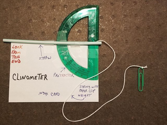
- Build yourself a clinometer. See Clinometer image - tape all parts together. Look through the proper end and the string will cross the protractor at the angle you are trying to determine. You can also search on-line for step by step instructions on how to make/use one.
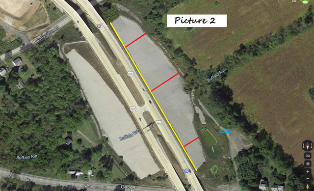
Use Picture 2 to help with the following:
- Using your favorite method, measure along the three red lines as shown in picture 2 and take an average. (DO NOT measure the actual picture provided, use your favorite software/on-line program to obtain the real approximate distance, the picture just shows you about where to take your measurements) Call the average B.
- Using your favorite method, measure along the yellow line as shown in picture 2. (Again, do not measure the actual picture provided, determine the real approximate distance.) Call this L.
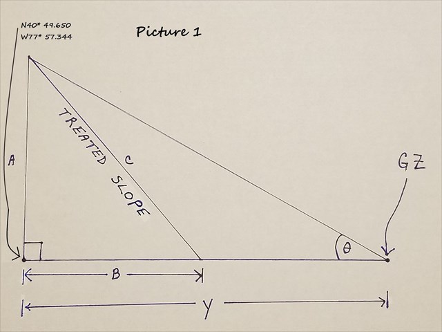
Use Picture 1 to help with the following:
- While at the posted coordinates, use your clinometer, face 245* and determine the angle from where you are to the top of the treatment area. Call this angle Θ (theta).
- Measure how far above the ground your eye is. Call this X. We are going to assume your feet (or the bottom of your wheels – as you don’t even need to leave your car or you can be sitting in a wheelchair) are at the same altitude as the base of the treatment area.
- Using your favorite method, determine how far away the posted coordinates are from N40* 49.650 W77* 57.344 Call this Y.
- Determine the height of the treatment area. Call this A.
Hint 1: lighter than brown
Hint 2: don’t forget where your eyes were when using the clinometer.
- Determine the length of the slope (C) of the treatment area.
Hint 3: somebody had a theorem
- Guestimate how deep you think the pyritic rock is under the treatment area. Call this D.
- Calculate the volume of pyritic rock in this treatment area based on your guestimation (D) and your above calculations. Call this E. Provide this answer in CUBIC YARDS.
Please send me the following two items, via my geocaching profile,
DO NOT post in your online log even if encrypted
- A, B, C, E, L, X, Y and Θ
A,B,C,D,L,X,Y MUST be in yards and E MUST be in cubic yards, Θ MUST be in degrees.
- Convert E to a percentage of the 1 million cubic yards that were reported as unearthed.
Be sure to include units with all answers.
Put the following three items in your online log:
- State what you chose for D and give the reason you chose that number. Please note, there is no right or wrong answer to this. In reality, it varies and no one knows for certain.
- State whether your final guestimation of the amount of pyritic rock (E) was larger or smaller than you expected and why.(DO NOT POST E)
- Post a picture of yourself or a personal item with the treatment area in the background. You can receive extra kudos for creativity.
DO NOT ACCESS THIS EARTHCACHE FROM I99.
Use the gravel pull off on 322/N. Atherton St./Skytop Mountain Rd.
CONTRATULATIONS to Carels on the FTF