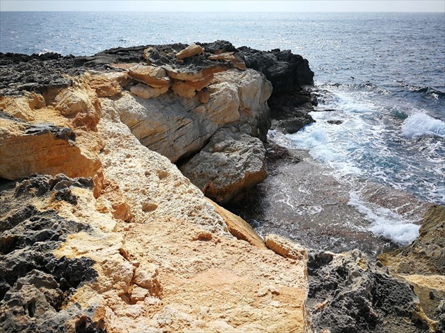
Estás ante tsunamitas.
¿Y qué són las tsunamitas? ¿Cómo han llegado hasta aquí?
Las tsunamitas son rocas que un tsunami ha cambiado de sitio. Es decir, son estas rocas que están superpuestas en fila a una cierta distancia de la costa. Fíjate que están imbricadas como fichas de dominó, como los coches después de una riada.
Pues sí, han llegado hasta aquí porque un tsunami, un tren de olas importantes las han sacado del mar y las han depositado sobre los acantilados.

¿Qué tsunami? ¿Hay tsunamis en el Mediterráneo?
Parece que en 1757 hubo un terremoto en Argelia que provocó el tsunami aparentemente autor de estas tsunamitas*.
Efectivamente el Mediterráneo es un lugar en el que pueden producirse tsunamis dado que al norte de África convergen las placas europea y la africana**. Esa fricción, a veces brusca, provoca los terremotos que a la vez provocan el tsunami.
Si la masa de agua (en ocasiones de kilómetros de profundidad) llega a zonas con acantilados no puede entrar tierra adentro hasta que no los rebasa: choca contra ellos, comienza a ascender, como si el nivel del mar subiera rápidamente, y cuando los supera, el flujo es tan grande que arranca bloques, trasportándolos tierra adentro.
Afortunadamente parece que el hecho de tener acantilados en el sur de Mallorca y de que las pendientes submarinas tienen cierta inclinación que ralentizan la velocidad y fuerza de las olas, reduce los riesgos de sufrir destrozos o catástrofes****.
¿Cómo sabemos que son tsunamitas y no tempestitas?
Porque están imbricadas, superpuestas y con un “cierto orden” por unas olas concéntricas. Las tempestitas son depositadas por una tempestad, olas sin orden ni concierto***.
En las coordenadas encontrarás un grupo de rocas. Fíjate bien en ellas porque para firmar el caché debes responder a estas preguntas enviándonos un mensaje. Puedes firmar sin esperar confirmación. En caso de que las respuestas no sean correctas, nos pondremos en contacto contigo.
1- Ángulo respecto al suelo de la roca más alta.
2- Altura respecto al suelo de la roca más alta.
3- Distancia de la costa de este grupo de rocas.
4- Explica con tus palabras cómo han llegado estas rocas hasta aquí.
5- Opcional: foto con otras tsunamitas
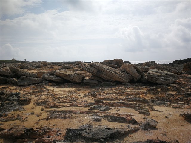
Waypoint2: Esto parece que ha tenido lugar recientemente, ¿no crees?
Aquí no debes responder ninguna pregunta, simplemente te lo enseñamos porque nos parece que es curioso ver como las rocas están arrancadas del acantilado y depositadas sobre éste pero del revés (fíjate la en parte negra y la parte marrón). Además, parece que los geólogos estudiosos han pintado unas marcas amarillas para hacer algún tipo de seguimiento.
*según las Notas Sueltas de Sismología Balear de Eduard Fontseré (1918), obra en que recoge una crónica de Nicolás Ferrer sobre un suceso acaecido el 31 de enero de 1757 en la zona de Santanyí, “donde el mar se adentró más de media legua en tierra, dejando las garrigas llenas de peces, el agua inundó la torre de vigilancia, llevándose rocas de grandes dimensiones”.
*según Rodríguez Perea, profesor emérito de Estratigrafia de la UIB, ”para trasladar alguno de los bloques tendrían que ser olas de hasta 20 metros, que no se producen en el Mediterráneo y menos en lugares encarados hacia el sur, por lo que necesariamente son tsunamis”. “Los bloques suelen presentar imbricaciones o acumulaciones de rocas que son indicadores de un flujo continuo”.
**”La placa africana está empujando a la europea, y este empuje se transforma en fracturas inversas que mueven el fondo del mar Mediterráneo”, explica Rodríguez Perea. “En la zona de Argelia las fracturas se mueven verticalmente, desplazando una masa de agua importante y las costas de Baleares orientadas hacia este país son las de mayor riesgo”.
***Según Francesc Roig, doctor en Geografía y Geología, “cuando el temporal azota la costa, desplazando grandes rocas, lo hace de forma muy poco organizada, pero si en vez de golpes de oleaje se trata del flujo de la enorme masa de agua de un tsunami, arranca los bloques de la cornisa, depositándolos tierra adentro, de forma muy parecida a como quedan los coches tras una riada, marcando por dónde entraba el agua y orientados hacia el norte de África”.
****Según un artículo publicado bajo el título “Modelo preliminar sobre el tsunami causado por el terremoto de Argel” de la científica Hélène Hébert, es debido a que las pendientes submarinas son bastante empinadas, especialmente hacia Mallorca que las olas del tsunami rebotaron en ellas y fueron reflejadas, y así Palma quedó protegida de una gran amplificación del oleaje.
Fuentes:
https://www.elmundo.es/baleares/2019/06/04/5cf62e2321efa0d0678b4598.html
http://diposit.ub.edu/dspace/bitstream/2445/68704/1/OIC_TESIS.pdf
https://recyt.fecyt.es/index.php/CUGEO/article/view/58166/pdf_54
https://arteygeologiajoaquindelval.blogspot.com/2016/12/tsunami-el-tren-de-olas.html
https://www.diariodemallorca.es/sucesos/2011/03/15/mallorca-salvo-tsunami-2003/653393.html
https://www.elmundo.es/elmundo/2003/05/22/sociedad/1053590416.html
ENGLISH
You are facing tsunamites.
And what are tsunamites? How did they get here?
Tsunamites are rocks that a tsunami has changed its places. I mean, it is these rocks that are superimposed in a row at a certain distance from the coast. Notice that they are overlapped like dominoes, like cars after a flood.
Yes, they have come here because a tsunami, a train of important waves have taken them out of the sea and deposited them on the cliffs.
What tsunami? Are there tsunamis in the Mediterranean Sea?
It seems that in 1757 there was an earthquake in Algeria that caused the tsunami that brought these tsunamites *.
Indeed, the Mediterranean Sea is a place where tsunamis can occur because European and African plates converge to North Africa **. That friction, sometimes abrupt, causes the earthquakes that cause the tsunami.
If the body of water (sometimes kilometers deep) reaches areas with cliffs, it cannot enter inland until it exceeds them, hits them, begins to rise, as if the sea level rises rapidly, and when it exceeds them, the flow is so great that it plucks blocks, transporting them inland.
Fortunately, it seems that the fact of having cliffs in the south of Mallorca and that the underwater slopes have a certain inclination that slows down the speed and force of the waves, reduces the risks of suffering damage or catastrophes ****.
In the coordinates you will find a group of rocks. Look closely at them because to sign the cache you must answer these questions by sending us a message. You can sign without waiting for confirmation. In case the answers are not correct, we will contact you.
1- Angle respect to the floor of the highest rock.
2- Height respect to the floor of the highest rock.
3- Distance from the coast of this group of rocks.
4- Explain with your own words how they came here.
5- Optional: photo with other tsunamites
Waypoint2: This seems to have taken place recently, don't you think?
Here you should not answer any questions, we simply show it to you because we think it is curious to see how the rocks are torn from the cliff and deposited on it but the other way around (look at the black part and the brown part). In addition, it seems that studious geologists have painted yellow marks to do some kind of follow-up.
* According to the Loose Notes of Balearic Seismology by Eduard Fontseré (1918), a work in which he collects a chronicle of Nicolás Ferrer on an event that occurred on January 31, 1757 in the Santanyí area, “where the sea entered more than half a league on land, leaving the forest full of fish, the water flooded the watchtower, taking large rocks. ”
* According to Rodríguez Perea, emeritus professor of Stratigraphy of the UIB, ”to move some of the blocks would have to be waves of up to 20 meters, which do not occur in the Mediterranean sea and less in places facing south, so they are necessarily tsunamis. " "The blocks usually have imbrications or accumulations of rocks that are indicators of a continuous flow."
** "The African plate is pushing the European one, and this push is transformed into reverse fractures that move the bottom of the Mediterranean Sea," explains Rodríguez Perea. "In the area of Algeria, fractures move vertically, displacing an important bulk of water and the Balearic coast towards this country is the most risky."
*** According to Francesc Roig, doctor of Geography and Geology, “when the storm hits the coast, displacing large rocks, it does so in a very unorganized way, but if instead of waves of swell it is the flow of the enormous mass of water from a tsunami, plucks the blocks from the ledge, depositing them inland, much like the cars are after a flood, marking where the water entered and oriented towards North Africa. ”
**** According to an article published under the title “Preliminary model on the tsunami caused by the Algiers earthquake” by the scientist Hélène Hébert, it is because the underwater slopes are quite steep, especially towards Mallorca that the tsunami waves bounced in them and they were reflected, and thus Palma was protected from a great amplification of the waves.
Sources:
https://www.elmundo.es/baleares/2019/06/04/5cf62e2321efa0d0678b4598.html
http://diposit.ub.edu/dspace/bitstream/2445/68704/1/OIC_TESIS.pdf
https://recyt.fecyt.es/index.php/CUGEO/article/view/58166/pdf_54
https://arteygeologiajoaquindelval.blogspot.com/2016/12/tsunami-el-tren-de-olas.html
https://www.diariodemallorca.es/sucesos/2011/03/15/mallorca-salvo-tsunami-2003/653393.html
https://www.elmundo.es/elmundo/2003/05/22/sociedad/1053590416.html
https://elpais.com/diario/2003/06/25/futuro/1056492007_850215.html