SPECTACULAR VIEWS... LOOK AND TAKE CARE NEAR CLIFF EDGES AND ON LOOSE ROCKS.
Turn onto Charles Knife Road between Exmouth and Learmonth and follow the road to GZ, where there is a small turnaround with trees and parking for a couple of cars. There are spectactular views on both sides of the road that will enhance your understanding and enjoyment of this section of Cape Range National Park. Closer to Exmouth the Shothole track can be accessed by 4WD.
Cape Range is composed of a sequence of predominantly calcareous sedimentary rocks of Palaeocene-Pliocene age overlain by Pliocene-Ilolocene alluvial, littoral, and shallow water marine sediments on the coastal plain, which borders the range. It is a gentle anticline (fold) resulting from inversion of fault movement on an underlying fault. Uplift has occurred intermittently since the Late Cretaceous era and affected sedimentation. The range emerged as an island and erosion (karstification) is thought to have rapidly extended down for about 100m in karst-prone limestone and gradually extended laterally as the range emerged. Deep erosion led to the present-day drainage system. Insoluble rock remained as buttes.
The present regional water table occurs below the level of erosion (karstification) in the central part of the range and within cavernous limestone around the margins. The groundwater is believed to occur as a layer of fresh groundwater overlying seawater. The remnant cave system in the central part of the range provides a relatively stable habitat for diverse subaerial cave fauna. The water-filled cave system on the coastal plain is the habitat of aquatic troglobites, and likely expanded in response to changes in climate and sea level. (Source: WA Museum)
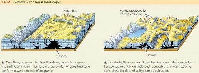
Limestone is a carbonate sedimentary rock that is often composed of the skeletal fragments of marine organisms such as coral, foraminifera, and molluscs. Its major materials are the minerals calcite and aragonite, which are different crystal forms of calcium carbonate. Limestone is porous and over time, water sculpts the rock into unique features.

You can log the earthcache immediately. Please send a message with your responses to the questions within a few days.
1. Standing at GZ, look to your right. How many caves do you see in the vertical rockface?
2. Looking across the canyon to the left there are more caves. In one word, how were these formed?
3. On the ground at GZ there are rocks sculpted by nature. Describe the texture and features. From your observations what kind of rocks are these?
4. A photo of you and/or your GPSr device or other personal item, in front of the canyon is required to log this earthcache. You can attach it to your log or include in the message with your responses.
Enjoy your visit to the spectaclar Cape Range National Park and Ningaloo Reef coastal region. Please no spoiler photos of GZ.