The Namib Sand Sea lies along the arid African coast of the South Atlantic lying wholly within Namibia’s Namib-Naukluft Park. It covers an area of 30,777 square kilometer, about a third of the total size of Namib desert.
The Namib Desert, the world's oldest desert, has existed for at least 55 million years, completely devoid of surface water but bisected by several dry riverbeds. Temperatures further inland are variable—summer daytime temperatures can exceed 45 °C (113 °F) while nights can be freezing.
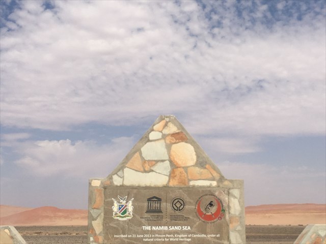
In 2013 the Namib Sand Sea was inscribed on UNESCO’s World Heritage List.
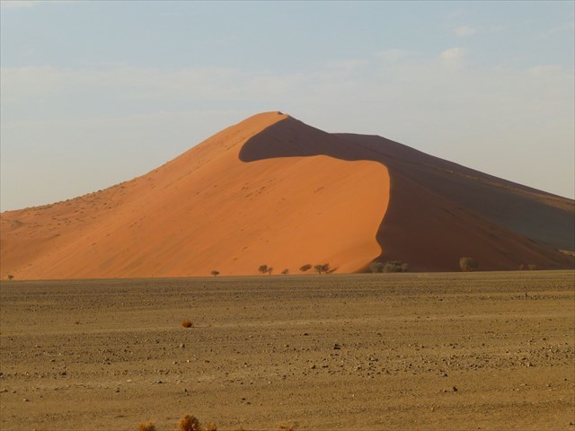
The dunes of Namib Sand Sea are among the highest in the world; many of them are above 200 metres, the highest being the one nicknamed Big Daddy, about 325 metres high, however the highest dune in the Namib Desert, Dune 7, is about 388 metres high. Dune 45 at 170 meters tall is the most well-known dune chosen to climb by tourists who visit the Sossusvlei area. This relatively 'easy' climb takes anywhere from 40 minutes to one hour to reach the top, for most people. Coming down takes less than 5 minutes.
Fog is a characteristic feature of the Namib Desert and is essential to life in this fog dependent system. It is often acknowledged that advective fog from the ocean is the dominant fog type over the Namib Desert fog-zone but recent evidence suggests that other fog types occur in this area. Knowledge of the existence and spatial distribution of different fog types will enhance the mechanistic understanding of fog formation and potential changes in this region, but such knowledge is limited in literature. In this study, we investigated fog spatial variations within the Namib Desert fog-zone by applying stable isotope (δ18O and δ2H) techniques to differentiate various fog types and identify their source waters. Isotope based results showed that at least three types of fog (advective, radiation and mixed) occurred in this region and what appears as a single fog event may include all three types. Results suggest that radiation fog was the dominant fog type during our study period. The results also suggest that advective fog (with Atlantic Ocean origins) either dissipated 30–50 km inland and the residual humidity combined with locally derived moisture to form mixed fog or advective fog incorporated local moisture along its trajectory inland resulting in mixed fog. Fog in the Namib Desert was consistently depleted in 18O and 2H compared to rainfall and this was attributed to sub-cloud evaporation of the rainfall as well as different sources of fog and rainfall. Sub-cloud evaporation led to enrichment of 18O and 2H in rainfall beyond that of the first stage condensate, fog. Advective fog is often considered the architect of the fog-zone in the Namib Desert, but our results demonstrated multiple dominant fog types during the study period, suggesting knowledge of both fog frequency and fog type is needed to better predict climate change impacts on the fog-zone.
We warmly recommend to read more details about geology of Namib desert (source: Wikipedia):
„The Namib is a coastal desert in southern Africa. The name Namib is of Khoekhoegowab origin and means "vast place". According to the broadest definition, the Namib stretches for more than 2,000 kilometres (1,200 mi) along the Atlantic coasts of Angola, Namibia, and South Africa.
From the Atlantic coast eastward, the Namib gradually ascends in elevation, reaching up to 200 kilometres (120 mi) inland to the foot of the Great Escarpment. Annual precipitation ranges from 2 millimetres (0.079 in) in the most arid regions to 200 millimetres (7.9 in) at the escarpment, making the Namib the only true desert in southern Africa. Having endured arid or semi-arid conditions for roughly 55–80 million years, the Namib may be the oldest desert in the world and contains some of the world's driest regions, with only western South America's Atacama Desert to challenge it for age and aridity benchmarks.
The desert geology consists of sand seas near the coast, while gravel plains and scattered mountain outcrops occur further inland. The sand dunes, some of which are 300 metres (980 ft) high and span 32 kilometres (20 mi) long, are the second largest in the world after the Badain Jaran Desert dunes in China. Temperatures along the coast are stable and generally range between 9–20 °C (48–68 °F) annually, while temperatures further inland are variable—summer daytime temperatures can exceed 45 °C (113 °F) while nights can be freezing. Fogs that originate offshore from the collision of the cold Benguela Current and warm air from the Hadley Cell create a fog belt that frequently envelops parts of the desert. Coastal regions can experience more than 180 days of thick fog a year. While this has proved a major hazard to ships—more than a thousand wrecks litter the Skeleton Coast—it is a vital source of moisture for desert life.
The Namib is almost completely uninhabited by humans except for several small settlements and indigenous pastoral groups, including the Ovahimba and Obatjimba Herero in the north, and the Topnaar Nama in the central region. Owing to its antiquity, the Namib may be home to more endemic species than any other desert in the world.
The Namib Desert is one of the 500 distinct physiographic provinces of the South African Platform physiographic division. It occupies an area of around 80,950 km (31,200 square miles), stretching from the Usiab River (north) to the town of Lüderitz (south) and from the Atlantic Ocean (west) to the Namib Escarpment (east). It is about 1,000 miles (1,600 km) long from north to south and its east-west width varies from 30 to 100 miles (48 to 161 kilometres). To the north, the desert leads into the Kaokoveld; the dividing line between these two regions is roughly at the latitude of the city of Walvis Bay, and it consists in a narrow strip of land (about 50 km wide) that is the driest place in Southern Africa. To the south, the Namib borders on the South African Karoo semi-desert.
Southern Namib (between Lüderitz and the Kuiseb River) comprises a vast dune sea with some of the tallest and most spectacular dunes of the world, ranging in color from pink to vivid orange. In the Sossusvlei area, several dunes exceed 300 meters (980 feet) in height. The complexity and regularity of dune patterns in its dune sea have attracted the attention of geologists for decades, but it remains poorly understood.
The source of the unconsolidated sand (the most recent sand sea) has been shown to be dominantly from the Orange River, which drains into the Atlantic south of the Namib Sand Sea, with minor contributions in the east from the (now ephemeral) rivers that drain into the sand sea. For this reason the Namib Sand Sea has been referred to as the "wind displaced delta of the Orange River."
Moving north from Sossusvlei, the sand gradually gives way to a rocky desert that extends all the way from Sossusvlei to the Swakop river. This area is traversed by the Tropic of Capricorn and is mostly flat, although some scenic canyons and elevations are found in some areas, for example in the Moon Valley system. While most of the soil is rocky, sand dunes are still occasionally found in this region; for example, sand dunes occupy much of the coastline between Walvis Bay and Swakopmund.
The Namib desert is an important location for the mining of tungsten, salt and diamonds.
Several rivers and streams run through the Namib, although all of the rivers south of the Cunene River and north of the Orange River are ephemeral and rarely or never reach the ocean. These rivers arise in the interior mountains of Namibia and flow after summer rain storms.“
The coordinates will lead you to a memorial stone that gives you some interesting information about the nomination of Namib Sand Sea as a World Heritage.
Tasks:
To log this cache you need to answer following questions via my profile email:
1. What kind of desert is the Namib Sand Sea as defined at the memorial stone?
2. Another example of this type of desert?
3. Please measure the altitude at the memorial stone.
4. Which mineral gems are in the Namib? (2 examples)
5. How many natural criteria were crucial for the World Heritage Nomination?