Beavers Bend 🌎verlook EarthCache

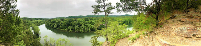
Beavers Bend State Park was named after John T. Beavers, a local Choctaw citizen, and was built on the site of an old Choctaw settlement. The "bend" in the park's name refers to this area of the park where a portion of Mountain Fork River meanders sharply, making an almost 180-degree turn. This EarthCache is located on Cedar Bluff where you can see this bend first hand!
To get credit for this EarthCache, be sure to complete the logging tasks at the bottom of this page.
Before We Begin:
- This EarthCache is on the Cedar Bluff Nature Trail. It is a 0.9 mile looping trail that takes you up the bluff to a spectacular view of the bend of the Mountain Fork River.
- Please note: This trail includes some significant inclines so it is not wheelchair or stroller friendly. However, older kids and four-legged members of the family should be just fine. Be sure to take your time and bring plenty of water.
- Follow the trailhead in the waypoint provided.
- You may park at the trailhead. NOTE: Oklahoma State Parks have began charging a nominal fee to park within park grounds. See local signs near the parking area for more information.
- There are two other EarthCaches nearby. Check them out: Beavers Bend F🌎lds and Beavers Bend N🌎vaculite
As this is an EarthCache, there is no container to find. Instead you will have an opportunity to learn about the following:
- Mountain Fork River and Broken Bow Lake Origins
- What is a meander?
Let's get started!
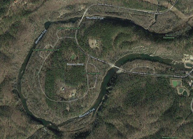
The "bend" of Beavers Bend
Mountain Fork River and Broken Bow Lake Origins
The Mountain Fork River begins about 35 miles north ATCF of this location. It starts its journey in Hodgen, Oklahoma before flowing Southeast into Arkansas and back Southwest again through Oklahoma, meandering across the map where it makes a pit stop into Broken Bow Lake.
Broken Bow Lake and dam was authorized by the Flood Control Act of 1958 and construction occurred between October 1961 and June 1970. The lake covers 14,000 acres and has a shoreline of 180 miles. The Mountain Fork River continues its journey right into a meander at the base of the dam. This is where we pick up on our EarthCache lesson.
Meandering River
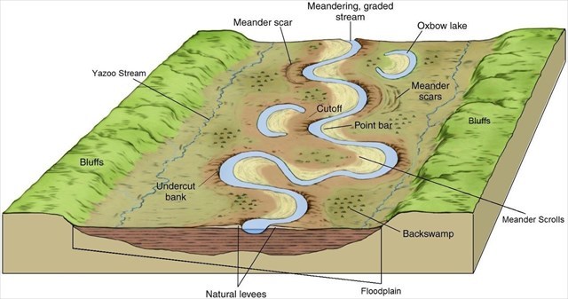
What is a meander?
Rivers that flow in gently sloping land tend to wander left to right making curves in the channel known as meanders. A meandering river is one that exhibits many bends and turns. The Mountain Fork River does this as well, especially north of here.
It is formed when the moving water in the river erodes the outer banks and widens its valley. A river of any volume may assume a meandering course, alternately eroding sediments from the outside of a bend and depositing them on the inside. The result is a snaking pattern as the river meanders back and forth.
Over time, meanders get larger and more pronounced as the outer edge has more material deposited on it. Given enough time, the meanders can get so curvy that they bend back and touch themselves creating an oxbow lake. Eventually, the neck will connect, the water will flow through the shorter course, and the oxbow lake will be left out of the loop.
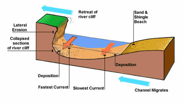
Outer bank erosion
An entrenched river is a river confined to a canyon or gorge, usually with a relatively narrow width and little or no flood plain, and often with meanders worn into the landscape. Such rivers form when the base level of erosion is rapidly lowered, so that the river begins down cutting into the channel faster than it can change course (which most rivers do on a constant cycle). This may occur due to tectonic uplift of the region, a lowering of the oceans, the collapse of a moraine-dammed lake downstream, or by capture of the river by another.
An incised meander is a river meander that has been cut abnormally deep into landscape because uplift of the land has led to renewed downward erosion by the river. There are 2 types of incised meanders: Entrenched Meanders and Ingrown Meanders. Entrenched meanders are symmetrical and form when the river down cuts quickly. The speed of the river down cutting gives less opportunity for lateral erosion. Thus giving them symmetrical slopes. Ingrown Meanders are asymmetrical. They form when the river down cuts at a slower rate, allowing the river to erode laterally and vertically.
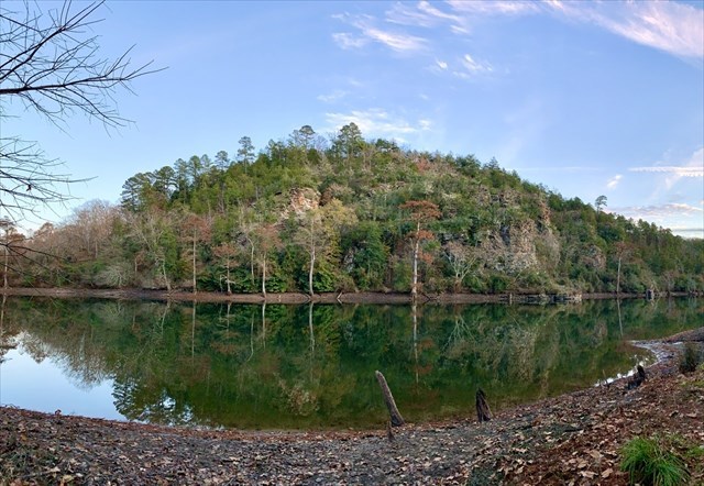
The view before you contains more than 350 million years of geological history, especially seen on the surrounding bluffs. Millions of years ago, the land here was fairly flat, and the river meandered on its course. When the Broken Bow Uplift occurred, it froze the position of this meander and entrenched it. As the land rose, the river flowed faster while continuing on its meandering course. The river cut into the land, eventually creating the entrenched meander that we see today.
To Get Credit For This EarthCache
Copy the questions below and send your answers via geocaching messages.
- DO NOT post the answers in your log.
- Group answers are fine, just let me know who all was there.
- Note: The photo task is a requirement for each account claiming a find. See acceptable EarthCache logging tasks effective June 10th, 2019. If you don't want to post the photo with your log, you may send it to me with your answers instead.
- Please send the answers in a timely manner or it may result in the deletion of your log (no offense intended).
Logging Tasks
1| The name of this EarthCache: Beavers Bend 🌎verlook
2| In a short summary, describe what a meander is and how oxbow lakes form.
3| Looking to the southwest from the overlook (toward the bend), what evidence do you see of the river's influence as it curves?
4| Since the dam was put into place, the flow of the river has been altered from its previous state. Take a look at the satellite map or the topological map. If the dam was never put into place, do you think this section of the river would have eventually formed an oxbow lake? Why or why not?
5| In your log, please provide a photo of yourself from atop the bluff with the "bend" behind you.
- If you prefer, the photo can be of a personal item here instead. Just make the photo unique to you and your visit. Feel free to have fun with this!
Optional: I'd love to see other photos you took from your visit here!
*IF YOU ENJOYED THIS EARTHCACHE,
CONSIDER GIVING A FAVORITE POINT!*
Sources:
Permission for this EarthCache placement was granted by Beavers Bend State Park.