Heavener Runest🌎ne Park EarthCache
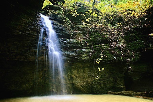
Photo by: Jason Brown/Flickr
Heavener Runestone Park is named after the park's main attraction, a large, vertical sandstone slab (10 ft wide by 12 ft high), bearing strange carvings resembling the runic alphabet. Through the tireless dedication of local resident Gloria Farley and numerous scholars, it is believed that Vikings traversed the Mississippi, Arkansas, and Poteau rivers and made the inscription sometime between 600 and 900 A.D., long before Columbus "discovered" America. Details about the inscription can be found on information boards at the Information Center and at the building that houses the runestone itself.
Before We Begin:
- Heavener Runestone Park is open 7 days a week from sun up to sun down.
- To get to this EarthCache, you will need to take the Runestone Interpretive Trail which begins near the Information Center and extends 200 yards down the ravine to the runestone area before looping back to where you began.
- Depending on recent rains, the counter-clockwise direction of the pathway may be covered in water so your shoes could get wet as you walk. IMO, this is the prettiest route to give you the best view but either direction will work.
- Please note: Due to the steep terrain, this cache is not wheelchair accessible.
To get credit for this EarthCache, be sure to complete the logging tasks at the bottom of this page.
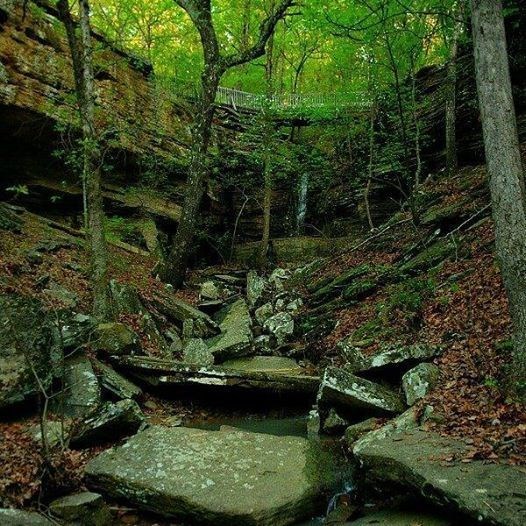
Photo by: Heavener Runestone Park
How do waterfalls form?
A waterfall is a geological formation resulting from water, often in the form of a stream or creek, flowing over an erosion-resistant rock formation that forms a sudden break in elevation or knickpoint.
The waterfall here at Heavener Runestone Park was created by Coal Creek flowing down hill thanks to our friend, gravity. Over time, the waterfall has formed this ravine as it has receded upstream, and it will continue to carve deeper into the ridge above it over time.
The waterfall formed at this spot because the shale that makes up the lower portion of the waterfall is relatively soft (3 on the Mohs scale) and was eroded more quickly than the harder sandstone rock (6-7 on the Mohs scale) above it.
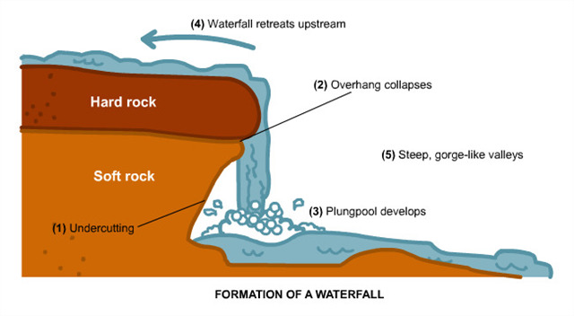
What is undercutting?
Often, the rock stratum just below the more resistant shelf will be of a softer type (shale in this case), meaning that undercutting due to splashback will occur here to form a shallow cave-like formation known as a rock shelter under and behind the waterfall.
Eventually, the outcropping of the more resistant cap rock (sandstone in this case) will collapse under pressure to add blocks of rock to the base of the waterfall. These blocks of rock are then broken down into smaller boulders by attrition as they collide with each other. They also erode the base of the waterfall by abrasion (wearing, grinding, or rubbing away by friction), creating a depression called a plunge pool downstream.
If suspended sediments in the water have not settled to the bottom of the waterbed, these sediments will grind and erode the land even faster when moving water rubs against it. The base continues to erode, the ridge eventually collapses, and the cycle can start all over again.
To Get Credit For This EarthCache
Copy the questions below and send your answers via geocaching messages.
- DO NOT post the answers in your log.
- Group answers are fine, just let me know who all was there.
- Note: The photo task is a requirement for each account claiming a find. See acceptable EarthCache logging tasks effective June 10th, 2019. If you don't want to post the photo with your log, you may send it to me with your answers instead.
- Please send the answers in a timely manner or it may result in the deletion of your log (no offense intended).
Logging Tasks
1| The name of this EarthCache: Heavener Runest🌎ne Park
2| What evidence do you see of undercutting and its effects on the sandstone cap above?
3| Is the waterfall confined to one spot or is it spread out across the ridge?
4| Find the "cave entrance" at the base of the falls and tell me why you're not allowed to go inside.
5| In your log, please provide a photo of yourself showing the waterfall or rock ledges behind you.
- If you prefer, the photo can be of a personal item here instead. Just make the photo unique to you and your visit. Feel free to have fun with this!
Optional: I'd love to see other photos you took from your visit here!
*IF YOU ENJOYED THIS EARTHCACHE,
CONSIDER GIVING A FAVORITE POINT!*
Sources:
Permission for this EarthCache placement was granted by Heavener Runestone Park.