The holy town of Rishikesh--in Sanskrit it is a name of Vishnu meaning "Lord of the Senses"--showcases two major geological features. Nestled at the foothills of a great mountain system, Rishikesh is the "Gateway to the Garhwal Himalayas". Flowing through this religious town, a most revered pilgrimage destination, is the sacred Ganges River. The geological theme of this Earthcache concentrates on Rishikesh receiving the start or source of a river which began as headwaters originating in the mountains, here the Himalayas. The part of the river that is nearest the source is often in a V-shaped river bed with quick flows downhill.

Look on this map above which shows the beginning of the river in the mountains and its course to the mouth or end. At the northwest corner, note where the Ganges River originates. The headwaters begin high in the Himalayan Mountains at the 12,769 feet elevation Gangrotri Glacier in India from the Bhagirathi River. The Ganges cuts southwest through the Outer Himalayas Siwalik Range at the northern edge of the Indo-Gangetic Plain to emerge at Rishikesh. It then flows onto the plain at Haridwar.
The volume of the river and rapidity of its flow are also affected by the mountains from which it originated. From April to June, Ganges River flows increase from the melting Himalayan snows. From July to September during the rainy season, monsoons cause floods. From November to February in the winter as the snow once again accumulates in the Himalayas, the Ganges flow declines. Vigor of the flow hastens erosion to the bed.
This Earthcache focuses on a small part of the Ganges River, most sacred to the Hindus, as it passes through Rishikesh, so that you may observe the surroundings and apply what you have learned about its being near the source. A location being closest to the origin of the Ganges means the water is likely the purest, most affected by the Himalaya snows melting, and whose sediments were altered by the rapidity and volume of water flow. What you observe here reflects all of these geological factors.
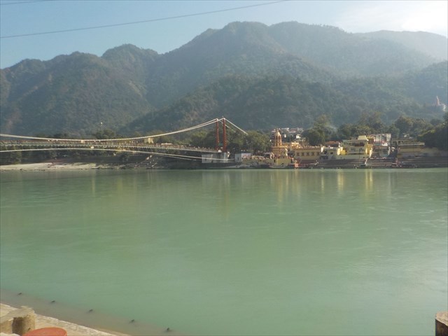
Coordinates will bring you to the entrance of the Sivananda Ghat where you may read a posted plaque about its origins. Stairs will take you down to the river waterfront. You may observe the Ganges close-up from this location, plus view the bridge and the structures on the opposite shore. You would expect that the river water in the town of Rishikesh compares very differently to that in the many towns down-river on the plain until final discharge at the Bay of Bengal. You would also expect the river's water level to vary considerably depending on what month you visit. When you are done with your observations here, you will walk to the Ram Jhula bridge which takes you to the other side of the shore. You will have a chance to see from the bridge the shoreline sediment below.
Logging Tasks to receive credit for this Earthcache:
1. Stand at the coordinates or higher up on the stairs, depending on water level. Look into the river's water. Briefly describe the clarity of the water, what substance is under the water forming the shore, rapidity of the flow, and the height of the river compared to the shoreline. Explain how the season impacted your answers.
2. Looking at the map, how do you think the sediments and water at this site, either at the coordinates, or at the end of the bridge on the other side, compare with the river's being even closer to the Himalayas, and being further away to the mouth, Bay of Bengal?
3. At the end of Ram Jhula bridge, please give the elevation according to your GPSr or other device. Does your answer match with the color codes for elevation on the map?
It is not necessary for you to seek outside sources to complete these tasks; all information can be found on this page, or at the site. Email or message your answers to me, separately from your log, which you may post right away as a "Find". Evaluate your environment and be safe first, as geocachers assume all risks of harm or injury. Enjoy learning about geology in this country and elsewhere in our world.
Examples of sources:
Nafis Amad, et.al., “Ganges River”, Britannica, at https://www.britannica.com/place/Ganges-River
Amanda Briney, “Geology of the Ganges River” May 25, 2019, at https://www.thoughtco.com/ganges-river-and-geography-1434474
Simon Scarr, et. al. "The race to save the river Ganges", Reuters.com, January 18, 2019, at graphics.reuters.com/INDIA-RIVER/010081TW39P/index.html