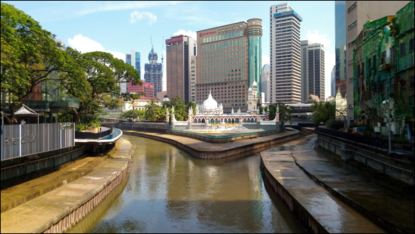
This EarthCache invites you to take a closer look at a muddy confuence. Responsible for its existence, this large geologic feature arguably constitutes the quintessential EarthCache for Kuala Lumpur, as Kuala Lumpur literally translates from Malay into English as "muddy confluence".
Type of EarthCache: Fluvial Landscape
Gombak and Klang River
Klang River (Malay: Sungai Klang) originates from the Klang Gates Quartz Ridge in Gombak, near the border with Pahang, 25 km northeast of Kuala Lumpur. It flows via Kuala Lumpur and Selangor into the Straits of Malacca, where its estuary is situated near Malaysia's biggest sea port, Port Klang. It is approximately 120 km (75 mi) in length and drains a basin of about 1,288 km² (497 mi²).
Its basin, known as Klang Valley, is a heavily populated area of more than four million people, and is to a large extent polluted due to heavy siltation caused by informal settlers of the riverbank, business establishments lacking sewage treatment plants, and sediment carried by mudflows from mountains. In some places, and this includes the confluence, heavy development has narrowed certain stretches of the river to the point that it resembles a large storm drain.
Klang River has 11 major tributaries, one of them being the Gombak River (Malay: Sungai Gombak). Gombak River used to be called Sungai Lumpur, or muddy river. Klang River's confluence with the Gombak River gave rise to the name of Kuala Lumpur, which means "muddy confluence".

Kuala Lumpur - Confluence of the River Klang and Gombak.
(Source: Barnyard Dawg, 2020)
What is a confluence?
A confluence, or conflux, is the location where two smaller rivers join to form one main stream or where two rivers separated by a strip of land upstream rejoin downstream.
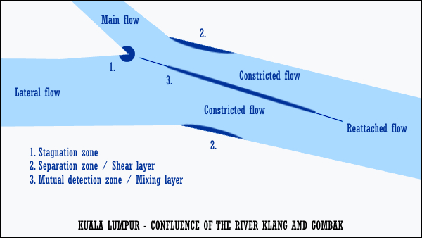
A confluence river holds various distinct zones of hydrodynamics, created by the confluence flow zones. For the confluence of the River Klang and River Gombak in Kuala Lumpur, the easier ones to recognise are; 1. The stagnation zone, 2. The separation zone or shear layers, 3. The mutual flow deflection zone or mixing layer. The confluence flow zones are represented by the main flow (Klang River) and the lateral flow (Gombak River). At the point of convergence, a stagnation zone is created. From the stagnation zone the mutual detection zone, in part created because of the constricted flow, extends downstream. Eventually, both flows mix and proceed as a reattached, single stream.

Kuala Lumpur - Confluence of the River Klang and Gombak.
(Flow Map: Barnyard Dawg, 2020)
How to claim this EarthCache?
The questions below are based on a moderate flow. It is understood that observations might slightly differ depending on the height and flow of the river.
Send me the following;
1. The text "GC8HV7A Kuala Lumpur - Muddy Confluence" on the first line.
2. The answers to the following questions;
- Describe the behaviour of the water in the stagnation and mutual detection zone.
- Do both flows mix immediately at the mutual detection zone? How can you tell?
- How far does the mutual detection zone extend, does it end before or after the bridge?
- Are the separation zones easily recognised? If yes, explain how.
3. Take a photo from the bridge, aimed at the stagnation zone.*
References
Finding the answers to an EarthCache can often be challenging, and many people tend to shy away from these caches because of this. However, it is my opinion that geocaching is also meant to be a fun family experience that simply aims to introduce interesting and unique locations such as this one. Flexibility on logging requirements, however, can only be applied if it can be established that you have actually taken the time to visit the site. For this reason, a proper log describing your adventure accompanied by a good number of photos would be much appreciated.