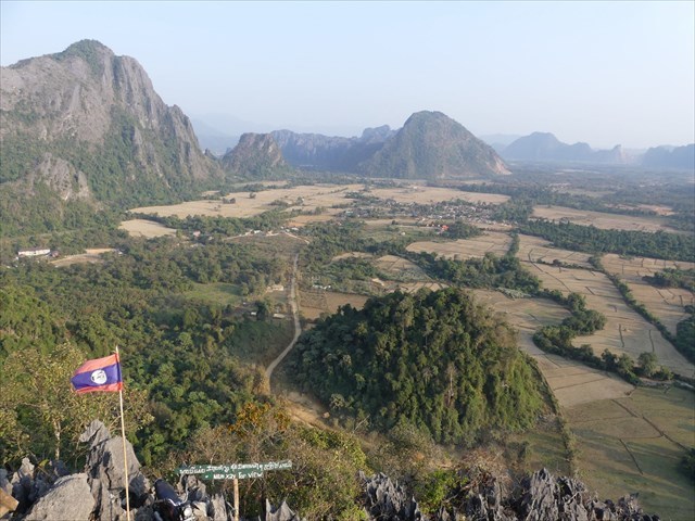
Nam Xay
Vang Vieng (Lao: ວັງວຽງ) is a town situated in Vientiane Province, Laos. The town lies on the Nam Song River. The most notable feature of the area is the karst hill landscape surrounding the town. One of the best places to view the karst landscape surrounding Vang Vieng is on top of Nam Xay viewpoint. Therefore we chose to put an earthcache on top of Nam Xay viewpoint as you have a perfect bird-eye view up here to observe different geological features concerning karst formation. Nam Xay Viewpoint is a 0.6 kilometer out and back trail located a roughly 20 minute drive from Vang Vieng, that offers scenic views of the surrounding landscapes filled with jagged cliffs and rice fields.
KARST
A karst landscape is typified as such when it primarily consists of limestone rock that is being dissolved.
Limestone is a type of sedimentary rock that is formed in the ocean by the precipitation of calcium carbonate. Over thousands to millions of years, the calcium carbonate can accumulate to form very thick layers of limestone rock. The shells of many animals, that live in the sea, consist of calcium carbonate. When the animals die, their shells are left as fossils on the ocean floor where they may accumulate into thick deposits.
Once this rock is uplifted above sea level by geologic forces, ground water sips through it and slowly dissolves it, creating a variety of karst forms: karst caves, tower karsts, karst fensters, cenotes, dolines etc.

The development of karst occurs whenever acidic water starts to break down the surface of bedrock near its cracks, or bedding planes. As the bedrock continues to degrade, its cracks tend to get bigger. As time goes on, these fractures will become wider and wider, speeding up the development of karst formations. The more water’s being able to flow through, the more erosion will occur.
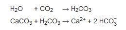
The carbonic acid that causes karstic features is formed as rain passes through the earth’s atmosphere picking up carbon dioxide (CO2), which dissolves in the water. Once the rain reaches the ground, it may pass through soil that can provide much more CO2 to form a weak carbonic acid solution, which dissolves calcium carbonate. The primary reaction sequence in limestone dissolution is the following:
LOG REQUIREMENTS
To log this cache, please do answer the following and send us a message or e-mail.
You can log without prior permission but, incorrect or missing logs will be deleted.
Any log without a picture will be deleted.
- Measure the altitude at the trailhead and on top of Nam Xay.
At what elevation is this karst formation towering above the valley floor?
- Describe the karst at your feet… color, structure, sharp/rounded…
- Take a closer look: the karst limestone has marine origins.
What can you see in the karst that proofs this?…
- At GZ, look 360 degrees around you. The viewpoint you’re standing on is a typical example of tower karst. In which direction can you see another perfect example of a sole-standing tower karst. How high would you estimate this other tower karst (knowing how high the viewpoint is you’re standing now – question 1)
- On top of Nam Xay, take a picture of yourself (you are NOT obliged to be recognizable on the picture), or your GPS/smartphone, or your GC-name.. Add it to your log. Any log without a picture will be deleted.

PALARUNCA @ NAM XAY (29-12-2019)