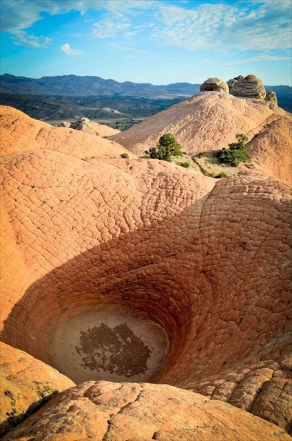
This is a moderate hike of about 2 miles roundtrip. This area in Sand Cove near Gunlock, UT has a lot of great formations and various layers and types of rock from Basalt, White Sandstone, to Red Sandstone. This is a pothole formation on the very top of a formation referred to as Camel Back Mountain. This formation is intriguing and anomalous due to the way erosion of sandstone normally takes place. Wind and Water are always the culprits, but water is always the ringleader. To erode away large portions of sandstone it always requires water and water that is in motion.
For starters, lets discuss the formation of a pothole in general. Potholes generally form from predominately in streams where just the right amount of sand, gravel, and rocks can be swirled within the eddies of a stream channel. These rotational currents create a vortex which can spin a large amount of debris from the bedload like a giant drill-bit, eroding out depressions in the bedrock of the canyon floor. When the flow rate is high enough to mobilize the bedload of keeper potholes, the abrasive grinding sound has been known to be audible to those nearby. For the stream to deepen the pothole, it is essential that the flow’s carrying capacity be capable of mobilizing nearly the entire bedload. If the size of rocks and debris in the bedload exceeds the flows carrying capacity, the channel’s potholes will fill up, prohibiting active erosion. If the channel has little to no bedload the flow will lack the abrasive material needed to rapidly “drill” into the channel. Canyons with keeper potholes usually have a delicate balance between stream capacity and bedload volume which keeps debris constantly filling up and emptying out of the potholes from one season or flood to the next. This is one of the reasons that most of Utah’s deepest keeper potholes form on the steeply tilted rock strata of San Rafael Swell or Waterpocket Fold in Capitol Reef National Park and the high hanging canyon areas of Zion National Park where there are no highly resistant rock units upstream to choke the stream channel with large, hard boulders.
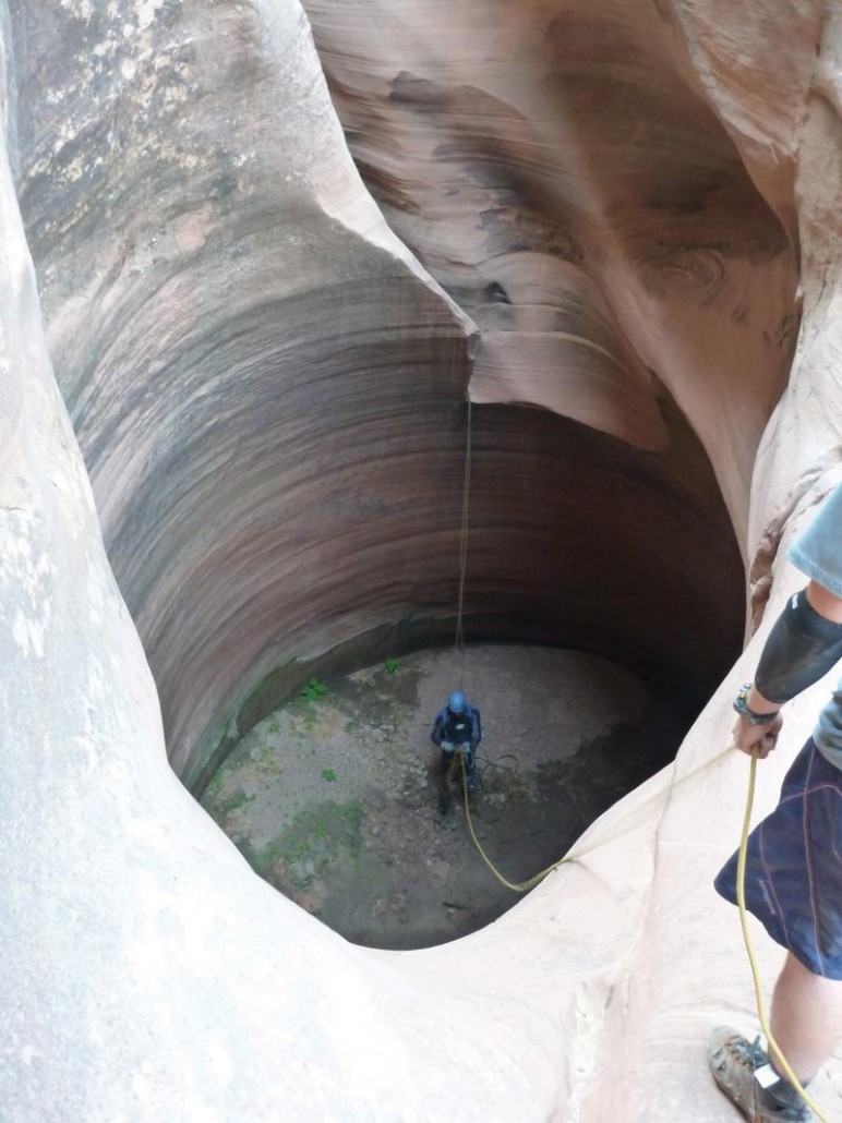
Stream channel shape and rock type: In Utah, keeper potholes are common in cliff-forming sandstone units such as the Navajo Sandstone, Wingate Sandstone, White Rim Sandstone, and Entrada Sandstone. Potholes often form away from water channels, but tend to be deeper, steeper-sided, and more prevalent when they form within winding water channels subject to flash flooding.
The shape or morphology of the stream channel is important because a bending or winding stream channel is more likely to create the fluvial eddies that facilitate pothole formation. Drop-offs or waterfalls, caused by vertical changes in rock density, are notable contributing factors for the same reason.
The general density and cohesive strength of the rock unit is also important. For deep keeper potholes to form, the rock unit must be soft enough to be eroded by the debris-laden flow, but hard enough to maintain near vertical faces without crumbling or collapsing.
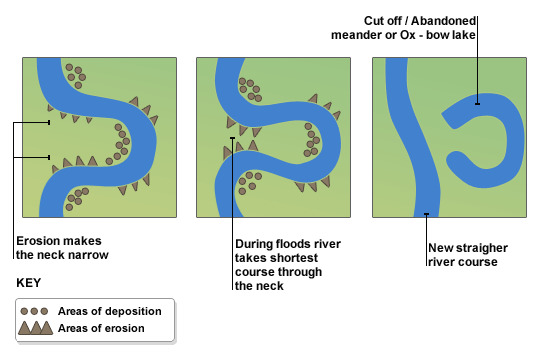
In this particular case, this formation is obviously not in a stream bed, but on top of Camelback Mountain. How can that be? Well, this was not always on top of a a mountain. It was at one time the bottom of a canyon and the river was diverted as a canyon sandstone fin or hoodoo or large sandstone monument would be formed, but in this case the pothole was captured within the formation keeping it in tact. It will however fill with water and may in fact have water when you discover it, but the water evaporates and the remaining sand is blown away in the harsh wind that beats on Camel Back Mountain. See the following Illustration:
To Log this Earthcache:
1. What direction was the water running originally when this pothole was formed.
2. looking from the South side of the pothole, what direction generally did the water swirl when it was formed? (looks at the striations on the sand stone and the direction as the flow down)
3. When this pothole meets it's demise, what direction will the water flow out of the pothole? (Hint: lowest spot on the pothole)
4. Please add a photo of yourself or with something unique to you added at the formation.