Bowmont Park is a large Natural Environment Park that is 192 hectares in size. It lies along the northern bank of the Bow River in the northwest part of Calgary between Bowness and Silver Springs.
The park was created in the early 1980s and the name of the park comes from the contraction of the name of the nearby communities of Bowness and Montgomery.
The bedrock underlying Bowmont NEP is known as the Porcupine Hills Formation. This bedrock was formed about 60-65 million years ago.
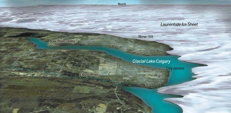
With the retreat of the Laurentide Sheet, the site was flooded by a glacial lake over 10,000 years ago. Glacial Lake Calgary filled much of the Bow River Valley as far west as Morley. As the Bow River wound its way west, it cut deep valleys and cliffs into the loose, fine grained sediments deposited by Glacial Lake Calgary. This process resulted in the landforms characterized by the Bowmont NEP: steep escarpments, sandstone outcroppings, ravines, floodplains and river islands.
DIGITAL RENDERING OF THE LAURENTIDE ICE SHEET ON TODAY’S LANDSCAPE (Terry Poulton, GSC)
Along the short trail to this EarthCache, you will find stairs, a boardwalk, springs, some small waterfalls, and a great riverside lookout. There are also some information signs at each of the waypoints. At the end of the trail, you will discover tufa deposits.
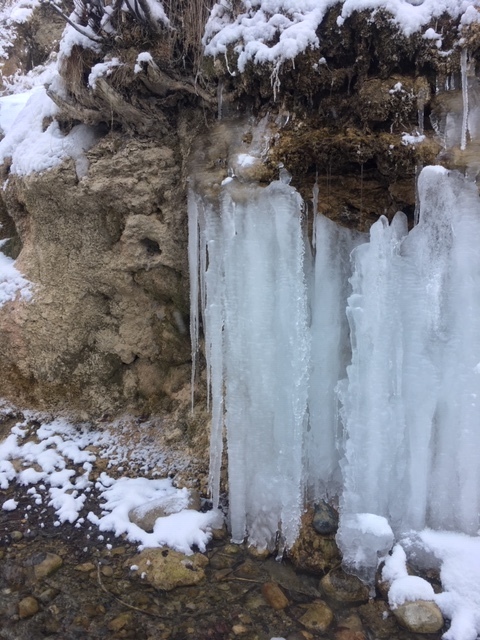
The glacial till and sandstone in this are are both rich in calcium carbonate and are easily dissolved by ground water seeping down through the hillside. Tufa, or calcium carbonate deposits are exposed as a result of active springs at the west end of Waterfall Valley.
When water percolates down from the surface, through the sediments it absorbs calcium carbonate. As it strikes the bedrock it flows sideways and exits out the side of the valley resulting in the falls in the Waterfall Valley. The water then deposits the calcium carbonate on the algae covered rock, producing tufa.
To log this earth cache:
Provide a description of the tufa deposits by the waterfalls at the EarthCache site and explain how they were formed.