Welcome to Barnhill Quarry, this is the second in a series of 4 simple EarthCaches. Each one is based on a geological feature that occurs here.
The youngest rocks at Barnhill are the Triassic Sediments seen above the Carboniferous Limestone. There are two key Triassic Formations noted at Barnhill.
Mercia Mudstone Formation (210-233 million years ago).
The sequence of red brown deposits which you can see in front of you date to the Triassic Period and are located above the unconformity(See next section). The key feature noted here is an infilled wadi feature which is indicative of arid environments. A wadi is an ephemeral stream or river in a desert which is prone to flash flooding during periods of rainfall. Modern examples are located in the Arabian Peninsula and the Israeli desert as well as in the deserts of South America. The wadi feature seen in the quarry has been infilled with large angular blocks of Carboniferous Limestone up to 1m in diameter within a matrix of red brown mudstone. This is likely to represent the high energy environment of a wadi during flooding with the water able to erode and move large blocks of limestone bedrock. The overlying beds consist of a series of sandstones, siltstones and mudstones representing a gradually fining upwards sequence and is interpreted as being indicative of gradually increasing sea levels.
Rhaetic Deposits (206-210 million years ago).
To the east of the quarry the Triassic sequence comprises clays of the Penarth Group including the Westbury Shale Formation. An academic paper published in 1938 indicates that these strata dated from the Rhaetic Period of the Triassic and included a basal bone bed which included the fossilised remains of early reptiles, vertebrates and fish. Sadly no evidence of this bone bed was found during the Geoconservation Survey of the quarry and it is likely that this material was removed during the quarrying process. These deposits represent a change to marine conditions once again towards the end of the Triassic period.
Unconformities
In the geological record, strata follow the Principle of Superposition, whereby in an undisturbed sedimentary sequence, the beds on the bottom are deposited first and are therefore the oldest, with the youngest rocks overlying them. Gaps in the geological sequence are often observed where sediments of a particular age are missing - either having been eroded away; or due to a lack of sedimentation at the time. These features are referred to as Unconformities.
Within Barnhill Quarry there are two main ages of rock, the Carboniferous Limestone (circa 340 million years old) and the overlying Triassic Sediments (circa 210-230 million years old) which form the red brown sandstones and mudstones. There are no sediments of Permian Age within the local area. During this time, the UK was part of a super-continent called Pangaea, at which time there was very little sedimentation. When sea levels started to rise and the super-continent broke apart, the next major period of sedimentation was during the Triassic Period which formed the red beds which overlie the Carboniferous deposits.
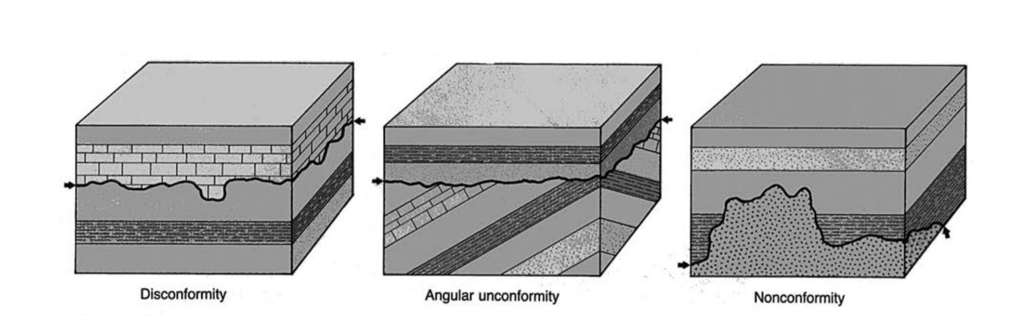
Types of Unconformity
There are several types of unconformity seen within the geological record.
Disconformity These represent a period of erosion of the underlying strata due to uplifting of the rocks or sea level change. The older and younger rocks are in the same orientation, however, there will be a marked erosion surface highlighting the topography of the former land surface.
Angular Unconformity They are the easiest unconformities to identify as the underlying rocks have been uplifted and tilted due to tectonic processes so that they are angled at a different orientation to the overlying sediments.
Non conformity or paraconformity These are the hardest type of unconformity to recognise in the geological record as the older and younger rocks are parallel to each other and there is often no obvious erosion surface. These unconformities represent a break in the sedimentation rate and are usually identified through analysis, of the Fossil record of the relative sediments.
 Please answer the following questions
Observe the rock face in front of you.
Describe how the boulders appear under the top stone layers ?
Describe the appearance of the top layers of rock, are they horizontal or dipping? Loose textured or solid what type of rock do think it is? (From those mentioned above)
Describe the position of the limestone layers, are they angled or flat?
What type of conformity is evident here? Please explain why you came to this conclusion
Please do not post answers in your logs
Please send the answers to me by email or via the message centre by clicking on my profile.
| I have earned GSA's highest level: |
 |