
La Earthcache / The Earthcache
La Ceinture dorée est le nom d'une portion du littoral breton à cheval entre le Léon et le Trégor.
Elle s'étend de Brignogan à Plougasnou et se caractérise par des conditions pédologiques propices à la culture légumière, dont les oignons autrefois transportés vers l'Angleterre par les Johnnies.
C'est cependant un tout autre type d'oignons beaucoup plus géologiques qu'on trouve fréquemment sur les bords de champs et l'estran entre Plounevez-Lochrist et la baie de Goulven à Keremma.
Partons étudier ces oignons venues du fond des âges géologiques.
► Contexte géologique local
Les formations plutoniques de la région entre Brignogan à Plouescat se sont mises en place il y a 300 millions d'années, postérieurement à l’orogenèse hercynienne.
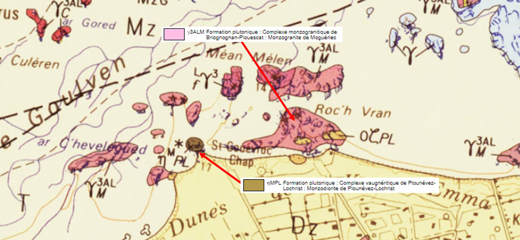
Au milieu du massif de monzogranite s'est introduit un petit satellite mafique, la monzodiorite de Plounévez-Lochrist, typique de la fusion partielle de roches plutoniques en zones de subduction.
► La Monzodiorite, roche plutonique intermédiaire
La monzodiorite est une roche magmatique plutonique à texture grenue composée de feldspaths (orthose et andésine), d'amphibole verte (hornblende) et de biotite (mica noir).
Elle se distingue du gabbro par l'absence d'olivine et du granite par la faible quantité de quartz qui apparaît ici surtout en ocelles.
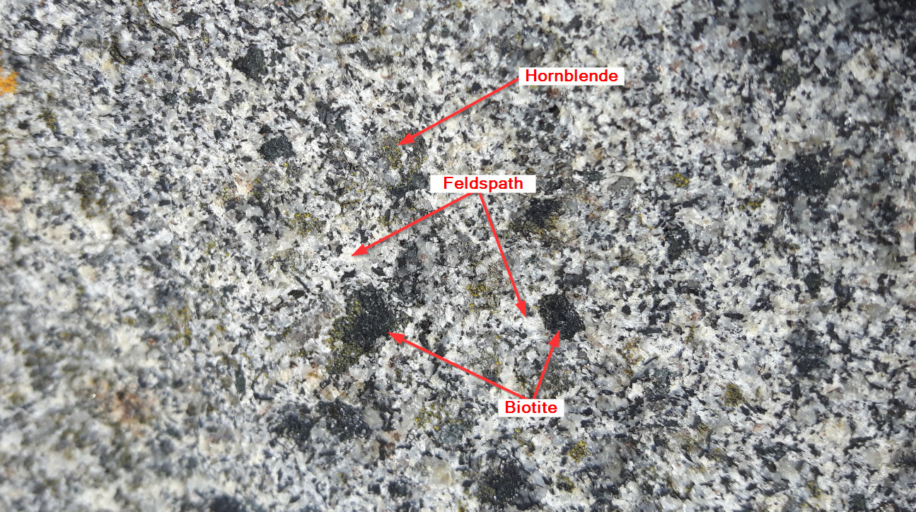
De teinte gris foncée, à grain moyen et très riche en ferromagnésiens, cette roche provient de magmas intermédiaires entre les magmas acides granitiques et les magmas basiques à gabbros.
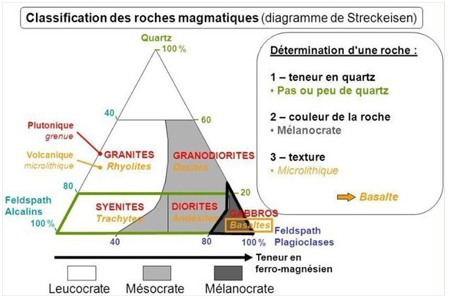
D'après le diagramme de Streckeinsen, il s'agit d'une roche mésocrate (à coloration intermédiaire).
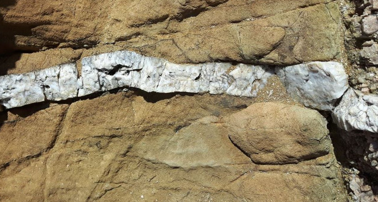
Roche dure et donc cassante, elle présente de nombreuses fractures (diaclases), dans lesquelles ont pu s'injecter du quartz venant du jus magmatique résiduel, formant des filons de pegmatites blancs dans l'encaissant monzodioritique.
► L'altération sphéroïdale ou altération en pelures d'oignons.
La monzodiorite, comme la plupart des roches magmatiques (ex : granites, basalte,...) sont des roches dures et cohérentes.
L'altération se fait au travers de fractures (ou diaclases) dans lesquels l'eau va s'infiltrer.
Cette eau pénètre dans des diaclases et altère les minéraux constituant la monzodiorite (feldspaths et biotite).
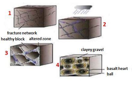
Progressivement, les diaclases s’élargissent et les blocs de monzodiorite prennent des formes arrondies caractéristiques.
L'altération se poursuit vers le centre des blocs et donne des écailles.
Ces blocs s’altèrent en se désagrégeant par couches successives qui desquament les unes après les autres, donnant un débit en "pelures d’oignons".
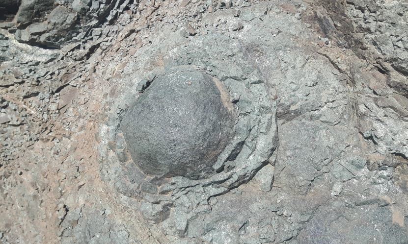
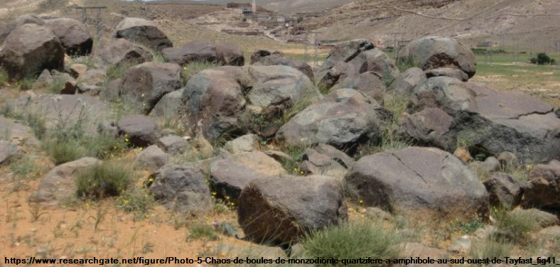
L'altération se poursuit vers le centre des blocs et donne des boules sur l'estran ou sur le sol pour la partie continentale.
Pendant des siècles, la libération par l’érosion de boules très saines de monzodiorite a fourni un matériau directement accessible, sans coûteux travaux de « découverte ».
The Golden Belt is the name of a portion of the Breton coastline straddling Leon and Trégor.
It extends from Brignogan to Plougasnou and is characterized by soil conditions conducive to vegetable cultivation, including onions once transported to England by the Johnnies.
However, it is a very different type of onion much more geological that is frequently found on the edges of fields and the foreshore between Plounevez-Lochrist and the bay of Goulven in Keremma.
Let's go study these onions from the depths of geological ages.
► Local geological context
The plutonic formations of the region between Brignogan and Plouescat were established 300 million years ago, after the Hercynian orogeny.
In the middle of the monzogranite massif, a small mafic satellite was introduced, the Plounévez-Lochrist monzodiorite, typical of the partial fusion of plutonic rocks in subduction zones.
► Monzodiorite, an intermediate plutonic rock
Monzodiorite is a plutonic magmatic rock with a grainy texture composed of feldspars (orthosis and andesine), green amphibole (hornblende) and biotite (black mica).
It is distinguished from gabbro by the absence of olivine and from granite by the small quantity of quartz which appears here especially in ocelli.
Dark gray in color, with medium grain and very rich in ferromagnesians, this rock comes from intermediate magmas between the granitic acid magmas and the basic gabbros magmas.
According to the Streckeinsen diagram, it is a Mesocratic rock (with intermediate coloring).
A hard and therefore brittle rock, it has numerous fractures (deaclases), into which quartz injected from the residual magmatic juice could be injected, forming veins of white pegmatites in the monzodioritic casing.
► Spheroidal alteration or alteration in onion skins.
Monzodiorite, like most magmatic rocks (ex: granites, basalt, ...) are hard and coherent rocks.
The alteration takes place through fractures (or deaclases) in which the water will infiltrate.
This water penetrates into deaclases and alters the minerals constituting monzodiorite (feldspar and biotite).
Gradually, the deaclases widen and the blocks of monzodiorite take on characteristic rounded shapes.
The weathering continues towards the center of the blocks and gives scales.
These blocks deteriorate by disintegrating in successive layers which flake one after the other, giving a flow in "onion peels".
The weathering continues towards the center of the blocks and gives balls on the foreshore or on the ground for the mainland.
For centuries, the release by erosion of very healthy monzodiorite balls has provided directly accessible material without costly "discovery" work.
► Sources bibliographiques / Bibliographical sources
Les Questions / The Questions
!!! ATTENTION CACHE UNIQUEMENT ACCESSIBLE MAREE BASSE !!!
!!! WARNING EARTHCACHE ONLY ACCESSIBLE LOW TIDE !!!
Avant de vous y aventurer, consulter l'horaire des marées :
Before you go, check the tide schedule:
Horaires des marées pour la baie de Goulven.
La lecture attentive du descriptif de la cache, ainsi qu'une observation des éléments de terrain et un peu de déduction sont normalement suffisants pour répondre aux questions de cette EarthCache.
A careful reading of the description of the cache, as well as observation of terrain features and some deduction is usually sufficient to answer questions of this EarthCache.
Questions pour valider :"Cultures d'Oignons sur la Ceinture Dorée"
Questions to validate: "Onion Crops on the Golden Belt"
Après vous être garé au PK, descendez sur l'estran jusqu'au spot (photo WP1).
After parking at the PK, descend on the foreshore to the spot (photo WP1).
- Question 0 : Prenez une photo de vous ou d'un élément vous identifiant avec la baie de Goulven en arrière plan.
Cette photo devra au choix nous être transmise avec les réponses ou être ajoutée à votre log.
-Question 0 : Take a picture of yourself or something identifying you with Goulven Bay in the background.
This photo must either be sent to us with the answers or added to your log.
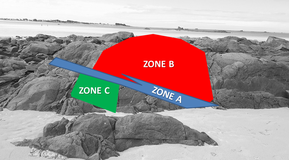
- Question 1 : Décrivez la roche sous la zone rouge A (taille des grains, couleur). En utilisant le diagramme de Streckeinsen, caractérisez là et déduisez en sa nature.
- Question 1 : Describe the rock under the red zone A (grain size, color). Using the Streckeinsen diagram, characterize it and deduce in its nature.
- Question 2 : En regardant la roche de près, vous pouvez voir principalement deux types de minéraux. Décrivez les et identifiez les.
- Question 2 : Looking closely at the rock, you can mainly see two types of minerals. Describe them and identify them.
- Question 3 : Que pouvez-vous observer sous la zone bleue A ? De quoi est faite cette structure et comment s'est-elle mise en place ?
- Question 3 : What can you observe under the blue zone A? What is this structure made of and how was it set up?
- Question 4 : Décrivez l'altération de la roche sous la zone rouge B. A quoi vous fait-elle penser ?
- Question 4 : Describe the weathering of the rock under the red zone B. What does it remind you of?
- Question 5 : Sous la zone verte C, vous pouvez voir une zone d'altération en coupe ; cela confirme t-il vos observations et déductions de la question 4 ?
- Question 5 : Under the green zone C, you can see a sectioned alteration zone; does this confirm your observations and deductions from question 4?
Vous pouvez vous loguer sans attendre notre confirmation,
mais vous devez nous envoyer les réponses en même temps soit par mail via notre profil (
fafahakkai), soit via la messagerie geocaching.com (Message Center).
S'il y a des problèmes avec vos réponses nous vous en ferons part.
Les logs enregistrés sans réponses et la photo seront supprimés.
You can log this cache without waiting for our confirmation, but you must send us the answers at the same time, by e-mail via our profile (fafahakkai) or by the system of Message Center of geocaching.com.
If there is a problem with your answers we will notify you. The logs recorded without answers and the photo will be deleted.
Rappel concernant les « Earthcaches »: Il n'y a pas de conteneur à rechercher ni de logbook à renseigner. Il suffit de se rendre sur les lieux, de répondre aux questions ci-dessus et de nous renvoyer les réponses.
Reminder concerning "Earthcaches": there is neither a container to look for nor a logbook to sign. One need only go to the location, answer to the differents questions and send us the answers.