Twelve Mile Coulee Natural Environment Park is a 150 hectare natural area and was so named because the distance from the post office in Fort Calgary to the top of the coulee along the trail to Cochrane was about 12 miles.
A coulee is a term that can be used to describe different landforms which refer to a kind of gully or valley that is usually dry and cut by water erosion. The term coulee is from the French-Canadian verb couler, which means "to flow," to describe this landform where seasonal water flows from snow-melt or heavy rains. As in most coulees, there is a mix of grassland, shrubs and trees.
Coulees resulting from water erosion are characterized by steep walls believed to have been formed by rapid melting of glaciers during the last ice age. The flooding from the meltwater resulted in massive down cutting, removing bedrock through massive erosion forming the steep walls. The water has since disappeared, and the majority of coulees are seasonally dry or have small streams. Because Twelve Mile Coulee functions as a storm water drainage site, the area is often wet.
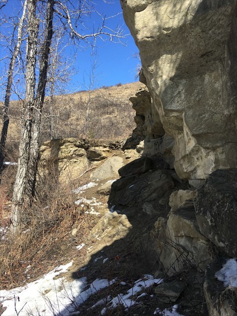
The dominant landform is the coulee itself, which slopes southerly toward the Bow River. Along the eastern slope there are sandstone outcrops which are part of the Porcupine Hills Formation of bedrock that underlies the entire city of Calgary. Toward the south end of the coulee, a large outcropping or bedrock is one of the best and most accessible examples of this formation in the city.
This coulee is approximately 110 m from the Bow River to the top. The deepest part is 50 m below the prairie surface. Because the slopes are steep and the soils are porous like a sponge, the valley walls occasionally slump if they become over saturated.
To log this earth cache:
1. Estimate the size of the sandstone outcrop at GZ and explain how the shape of the outcrop relates to the formation of the coulee?
2. Which direction do you think that water flowed when the coulee was formed?