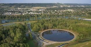
Dale Hodges Park is a 40 hectare Natural Environment Park that lies along the northern bank of the Bow River on the lands of a former Klippert gravel pit. The land was acquired from Klippert Concrete in 2010 to be turned into parkland and features storm water wetlands, wildlife habitat, walking and cycling trails and lookout points.
Dale Hodges Park is a stormwater treatment facility and the design highlights the natural and man-made processes involved in storm water management. It treats the runoff from rain and melting snow and makes the storm water treatment process visible as it travels to the Bow River.
Up until the 1980’s, The City of Calgary’s stormwater system involved a conveyance system only. The conveyance system includes catch basins collecting stormwater at the surface, as well as the underground system of pipes that carry the stormwater to the Bow River, where it is discharged through outfalls.
Storm drains or catch basins are the main way stormwater gets into the underground pipe system. There are about 60,000 drains in Calgary which drain water off sidewalks, streets and roads. Outfalls are exit points by which storm water leaves the pipe system and enters the river. There are more than 800 outfalls located across Calgary.
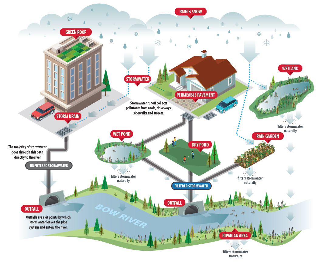
Every time it rains or snow melts, dirt and pollutants are washed into the storm drains. Stormwater and the pollutants can affect the health of streams, rivers and the land surrounding them, as well as the health of the wildlife and fish that rely on them.
The sediment carried in the stormwater affects the health of fish and pollutes their habitat. The storm water quality management system at this park is expected to reduce the annual sediment load to the Bow River from this catchment area by 50%.
At Dale Hodges Park, the stormwater quality management system includes the following elements:
Nautilus Pond™ - A circular pond that acts as a forebay for the stormwater quality management system. Stormwater enters the park though this circular pond which slows down the water and where larger sediment particles such as sand and fine silt collect at the bottom.
Polishing Marsh – water slowly moves through the soil and roots of the wetland plants which remove the very fine particles of sediment that still remain in the stormwater
Wet Meadow – the wet meadows are ephemeral wetlands that become wetter or drier depending on the amount of rainwater and snowmelt available. Even though water may not be visible at the surface, the soil is generally saturated. The wet meadow serves as a filter for stormwater as it moves through the plants and spongy soil and provides enhanced treatment of stormwater by removing very fine particles of sediment. The areas also provide marsh and wet meadow habitat for a variety of species.
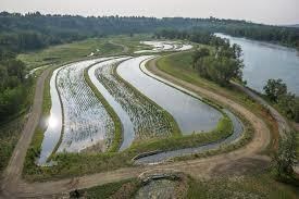
Streams – stormwater flows from the Nautilus Pond™ to the polishing marsh through a surface stream. Further down, the stream collects stormwater as it seeps out of the wet meadow and conveys it to the outfall. The stream roughly follows the route of and old side channel of the Bow River that existed before the gravel pit operation.
Riparian Areas - During larger storms, there may be water flowing into the stormwater system faster than can be safely released to the river. In these events, stormwater will bypass the polishing marsh and wet meadow and back up from the system into side channels in the riparian areas, temporarily creating a floodplain environment and supplying water to riparian plants along the side channels. Underlying gravel will allow this water to be absorbed into the ground.
To log this earth cache message the CO the answers to the following questions:
- What is the advantage of the stormwater treatment facility at Dale Hodges Park over the conveyance system?
- How much is the stormwater treatment facility at Dale Hodges Park expected to reduce the sediment load into the Bow River from its catchment area?
- How many outlet pipes do you see in the cement directly west of gz?
- Optional – post a picture of you and your gps while enjoying Dale Hodges Park