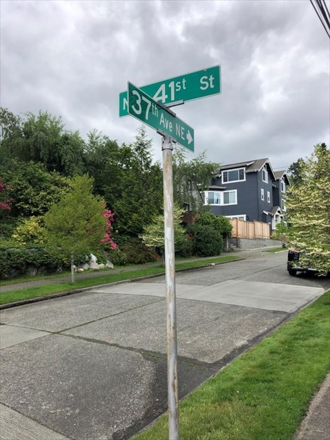
You are standing at the corner of NE 41st Street & 37th Avenue NE or what was originally called the corner of Watson Avenue (37th) and Front Street (41st).
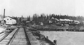
This was the foot of what was known as the Town of Yesler platted in 1888 as a company town to support Henry Yesler’s second sawmill in the area. It stood across the street where the UW Center for Urban Horticulture sits today. Shown below is a picture of the sawmill looking north from the water up the hill toward the town. The rail line is an extension from the Seattle, Lake Shore, & Eastern Rail line up the hill (now the Burke-Gilman Trail located 4 blocks north up 37th).
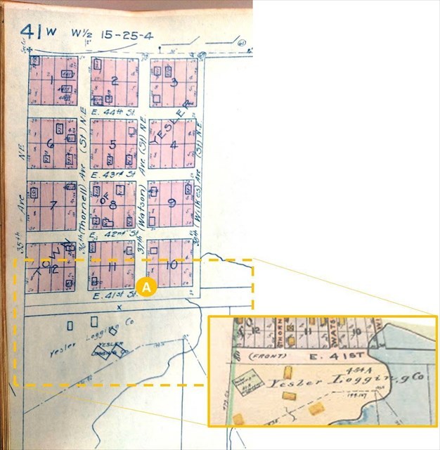
The sawmill burned down 7 years later in 1895. Union Ice Company also shared the same quarters to supply ice in the days before refrigeration. Another saw mill and shingle mill appear to have occupied the property in the subsequent years after the fire. The 12 blocks that made up the Town of Yesler were eventually incorporated into the City of Seattle in 1910. The town plat below from 1920 shows the original street names as well as the newer City of Seattle street names that are used today. You can also see the location of buildings/homes present at that time on the map….some of which are still there today.
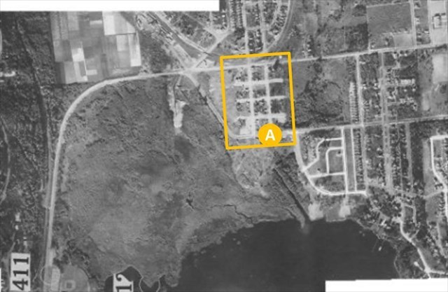
You can see the matching streets laid out in the 1929 aerial photo below
You are standing at “A” where the geocache is located along the current parking strip (not in the flower beds). We are the owners of the property the cache sits on. If we are out in the yard, stop and say hi.
---------------------------------------------------------------------------------------------------------------------------
Walking Tour
The short walking tour below using the 1920 town plat offers some additional historical items and neighborhood lore.
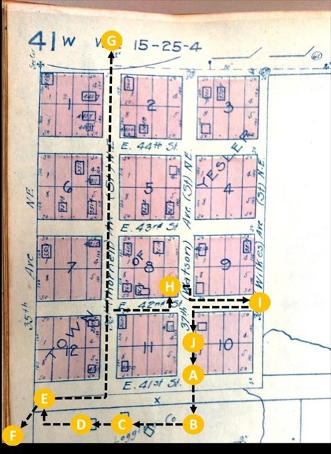
Stop A – Start your walking tour where you are standing at the corner of 37th (Watson) Avenue & 41st (Front) Street.
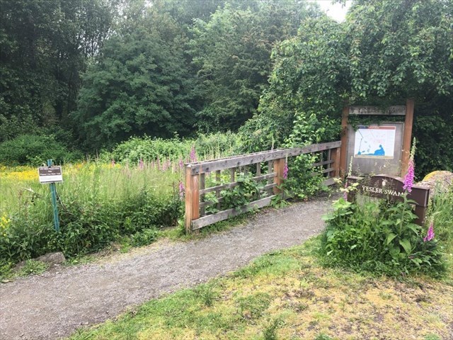
Stop B – Directly across 41st (Front) Street is Yesler Swamp (see picture below) that features a boardwalk recently built by the Friends-of-Yesler-Swamp which leads you thru a nature area created in 1916 when Lake Washington was lowered 9 feet with the opening of the Montlake Cut.
Stop C – Walk 1 block west along 41st (Front) Street to the parking lot for the UW Center for Urban Horticulture where the sawmills and ice house once sat.
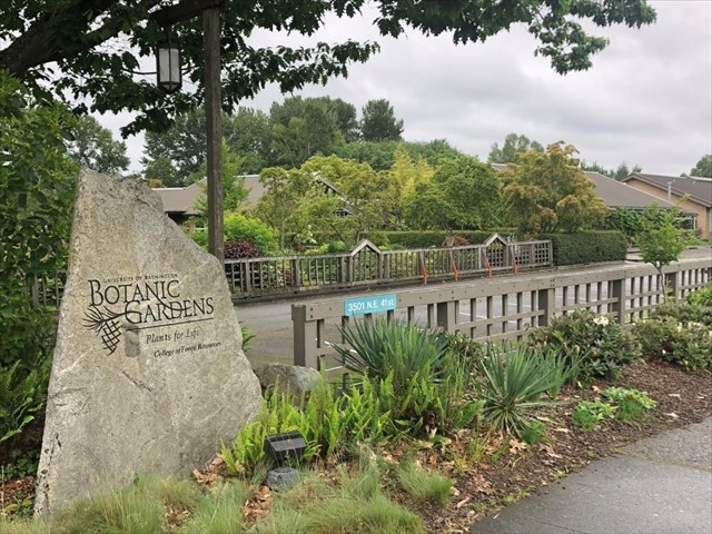
Stop D – Located just before the Center for Urban Horticulture building is the UW Botanical Gardens (see picture below) worth checking out by plant lovers and others looking for a nice spot to relax.
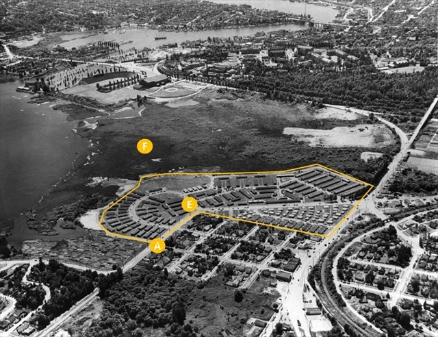
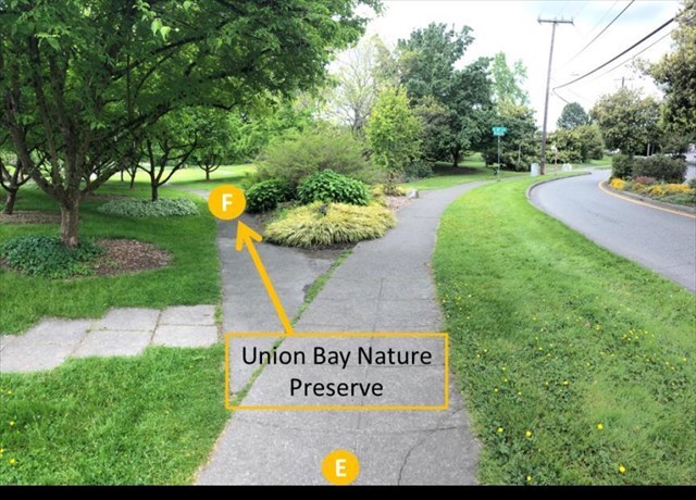
Stop E – Continue down 1 more block to the bend in the road. After WWII, the former sawmills and other nearby properties were turned into GI housing for UW students. From the aerial photo below, the geocache is located at “A” and the GI student housing is outlined (you are standing at “E”). You can see Husky Stadium and Hec Ed in the background.
Stop F – An optional side tour is the Union Bay Nature Preserve. Several paths wind thru the preserve which is very popular with runners, walkers, and bird watchers.
Over 50 years ago, much the area marked with an “F” in the aerial photo above was a landfill for the City of Seattle….now reclaimed as a nature preserve.
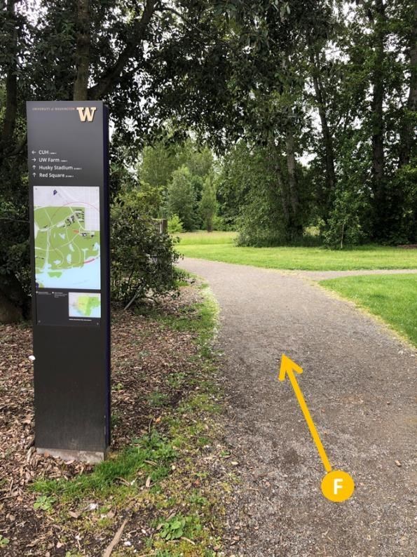
You can reach the preserve by following the path shown above from stop “E”. It comes out near the UW baseball, track, and soccer fields on the other side of preserve and along the way you’ll see notice boards listing the recently sighted birds that migrate thru the area.
Stop G – From “E”, walk back 1 block east to the corner of 36th (Thornell) Avenue & 41st (Front) Street. Turn left at the prominent green house and go 1 block north up to 42st Street. From here you have the option to go 3 more blocks north along 36th (Thornell) Avenue and cross 45th Street to the Burk-Gilman Trail…..arguably Seattle’s premier biking and walking trail.
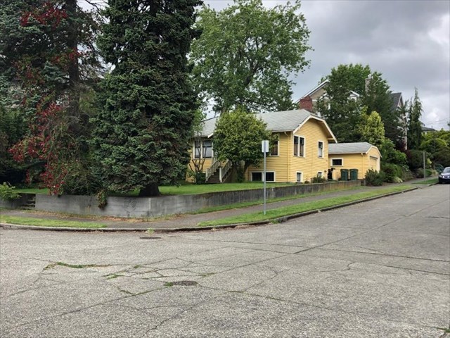
Stop H – Otherwise, turn right and go 1 block along 42nd Street to the intersection of 37th (Watson). Neighborhood lore has it that the yellow house located at the NE corner of this intersection is the original house for the manager of the 2nd sawmill still standing after all of these years. You can see a house sitting on this property in the 1920 plat shown above.
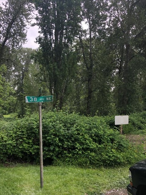
Stop I – Continue east along 42nd Street 1 more block to the dead end. This is supposed to be the corner of 42nd Street and 38th (Wilkes) Avenue NE as noted in the town plat above. 38th (Wilkes) Avenue is what’s known as a “paper street”. Still on the town books as a “real” street but never built. There is even a street sign designating the street that isn’t there.
If you look beyond the street, you’ll see a number of tall trees. They are home to our resident pair of bald eagles. If you listen carefully, you might hear their screeching/chortle-y (somewhat unappealing) call. Unlike those that migrate, resident pairs stay throughout the year tending their nest, feeding, and caring for eaglets. They do take a break in the fall after the eaglets are gone and leave for an extended vacation always returning together since they mate for life to the same nest. They primarily feed on fish in Union Bay and are very territorial. There have been 2 sets of resident pairs around Union Bay over the years….the other being located in the Arboretum to the south. Recently a 3rd pair has setup shop near Husky Stadium trying to divide up the territory into 3 parts. Eagles are magnificent birds and strikingly large when you are lucky enough to be near one. When kayaking in Union Bay, you might see one sitting nearby on a boat houses looking past you for fish.
Stop J – Go back west along 42nd Street 1 block and turn left at 37th (Watson) Avenue back toward the geocache. Halfway down the block you’ll notice powerlines and poles still present in this neighborhood.
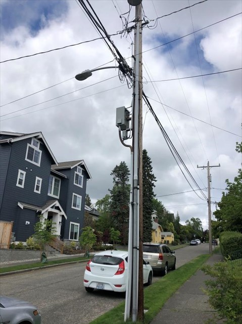
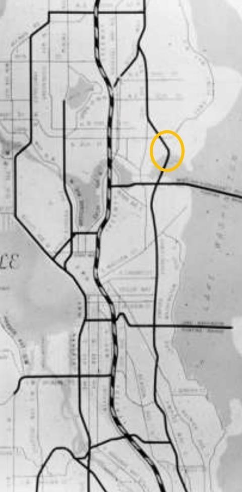
Neighborhood lore has it these were to be buried underground when the rest of Laurelhurst had its powerlines buried. However, the Town of Yesler was supposed to be razed to make room for a new freeway so the powerlines were left. This was going to be an extension of the never-built R.H. Thomson freeway. This freeway was part of a master plan for freeways to be built around Seattle (shown below with the Town of Yesler circled)
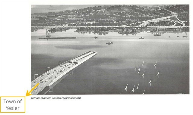
The RH Thomson freeway would have come north thru the Arboretum, down under Union Bay in a tunnel, and emerged where you are standing today. The artist rendition below is looking south across Union Bay toward SR520 and the Arboretum
Just a little further down the block, you are back at the geocache where you started. The Town of Yesler is now part of the Laurelhurst neighborhood. For more information on the origins of the Town of Yesler and the sawmill please see this article from the Laurelhurst Blog.