What are Breakwaters?
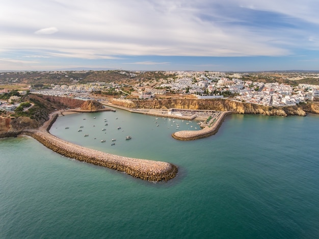
A breakwater is an offshore shore-parallel structure that “breaks” waves, reducing the wave energy reaching the beach and fostering sediment accretion between the beach and the breakwater. Made of rock, concrete, or oyster shell, these structures can be floating or fixed on the ocean floor and can be continuous or segmented. Breakwaters can be placed attached to the shoreline as headlands or submerged near the shoreline as sills.
What is the Purpose of a Breakwater? (pros of breakwaters)
Breakwaters reduce the intensity of wave action in inshore waters and thereby provide safe harbourage. Breakwaters may also be small structures designed to protect a gently sloping beach to reduce coastal erosion; they are placed offshore in relatively shallow water. In addition to beaches, artificial breakwaters are constructed to protect harbors from large waves. Harbors such as Plymouth Sound, Portland Harbor, and Cherbourg have used breakwaters to enhance their waters.
What are some Unintended Consequences of Breakwaters? (cons of breakwaters)
The dissipation of energy and relative calm water created in the lee of the breakwaters often encourages the accumulation of sediment (as per the design of the breakwater scheme). However, this can lead to excessive salient build-up (build-up of sand and other debris) in front of the breakwater, which reduces longshore drift shoreward of the breakwaters. This trapping of sediment can cause adverse effects down-drift of the breakwaters, leading to beach sediment starvation and increased coastal erosion.
What is Longshore Drift?
Sand moves to and from the beach in an onshore-offshore direction, but it also moves along the shoreline (“longshore”). This longshore sand transport is referred to as longshore drift, and because of it, beaches have been called “rivers of sand.” There have been special instances where the longshore currents have changed direction during storms, hurricanes, or an abrupt change of wind for a brief period of time.

The longshore current, the movement of water along the shoreline, is caused by:
Logging Requirements:
-
At the GZ, you will find two breakwaters that are parallel to the beach. What characteristics do you observe in these breakwaters that classify them as such?
-
At the GZ, do you think that the breakwaters are decreasing or increasing the wave action in the swimming area?
-
Are breakwaters increasing or decreasing beach erosion at the GZ? Why or why not?
-
As of June 2019, earthcaches are now allowed to have a required photo logging task. Please provide a photo of yourself, your GPSr, or a personal item that proves that you have visited this site. Please post this in your log.
**Please use caution around the breakwaters!**
Congrats to Skotlee, Hawaii-Geo, and kailua_matt for the FTF!
Enjoyed finding this EarthCache? Consider awarding it a favorite point!
Sources:
https://en.wikipedia.org/wiki/Breakwater_(structure)
https://www.nps.gov/articles/breakwaters-headlands-sills-and-reefs.htm
| We have earned GSA's highest level: |
 |