Skip to content

17 GSW Great Chart to Hothfield Traditional Cache

This cache has been archived.

mankybadger: Looks like someone knows where this cache is and has dinged it again.... i can't keep replacing just to have it going again

More
Hidden : 6/9/2020
Difficulty:
1.5 out of 5
Terrain:
2.5 out of 5

Size: Size:   micro (micro)

Join now to view geocache location details. It's free!

Watch

How Geocaching Works

Please note Use of geocaching.com services is subject to the terms and conditions in our disclaimer.

Geocache Description:


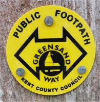
The Greensand Way is a long-distance path of 108 miles (174 km) going from Ham Street (some six miles to the south) to Haslemere (some hundred miles away in Surrey

It follows the Greensand Ridge along the Surrey Hills and Chart Hills. The route is mostly rural, passing through woods, and alongside fruit orchards and hop farms

The trail was opened on 15 June 1980 and is jointly managed by Surrey and Kent Councils


This is one of nineteen caches along the section of the Greensand Way from Great Chart to Hothfield. The route is quite obvious… Follow the Greensand Way

Once you’ve got to the end of this section you have two choices:

1: Keep on going along the Greensand Way

2: Turn around and come back:

Additional Hints (Decrypt)

Haqre gur evtug unaq sne fvqr (nf lbh nccebnpu)

Decryption Key

A|B|C|D|E|F|G|H|I|J|K|L|M
-------------------------
N|O|P|Q|R|S|T|U|V|W|X|Y|Z

(letter above equals below, and vice versa)