Little Sugar Creek was once listed among the state’s most polluted urban streams. To make way for progress, it was forced into pipes and buried underground. The Little Sugar Creek you see before you today is vastly different. It has become a model for stream restoration success.
Once an ugly eyesore of straightened channels, crumbling banks, and weedy brush, the creek has undergone a dramatic facelift. Water quality specialists and engineers have created more natural channels for the creek, which includes meandering turns, natural pools, stabilized banks, small wetlands, and increased floodplain areas. The increased floodplain area helps prevent flooding and filter pollutants from storm runoff. The greenway alongside the creek provides for pedestrian and cyclist enjoyment, as well as educational opportunities.
Now on to our lesson.
Floodplains:
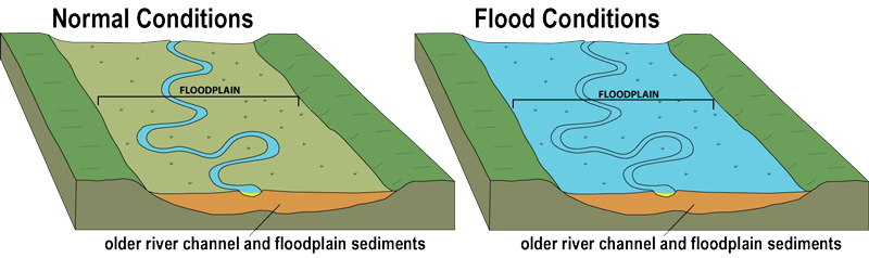
Floodplains are relatively flat areas along streams or rivers that are likely to experience repeated flooding. Over time, a floodplain will naturally form to hold excess water that spills over the banks of the stream or river. Basically, floodplains are designed by nature to flood. Because of this, floodplains are considered to be part of a healthy stream system. As you walk along the greenway here, you will witness the restoration of the floodplain for Little Sugar Creek.
The floodplain of a stream is a distinct ecosystem. It provides a habitat for the plants and animals that live adjacent to the creek. When the waters of Little Sugar Creek rise during a storm, the floodplain provides an overflow area. This overflow area slows down the water, which reduces the damage that may be caused by the flood. It also allows the plants within the floodplain to filter pollutants from the runoff as the water recedes.
Decades ago, homes and buildings were built over the natural floodplains in the Charlotte area. This was because the floodplain land was often flat and easier to develop. Building on local floodplains has been restricted since the late 1970’s when it was realized that protecting floodplains can reduce flood losses and improve the environment.
In some cases, a floodplain bench had to be added to the creek. This was necessary to reconnect the stream with its natural floodplain. Before the restoration, the banks of the creek were nearly vertical in places. This prevented the stream from spilling over into its floodplain during storms, which increased damage from floods.
The water flowing through this section of the creek can be traveling quite fast at times. Storm water runoff from the uptown area flows into Little Sugar Creek. You may find that some of the greenway is under water as it is part of the floodplain.
Riffles:

A riffle is a shallow area where fast moving water flows over pebbles and rocks. The flow of water in this area will appear to be disturbed, often looking wavy. Areas of streams with riffles naturally tend to be wider than other in-channel landforms. When an in-channel landform is shallow and narrow, instead of shallow and wide, it is called a nozzle.
Riffles are very important biologically. Many aquatic species rely on them in one way or another. Riffles are the main habitat of stream macroinvertebrates. Macroinvertebrates are small organisms with no backbone that can be seen with the naked eye. Some macroinvertebrates found in riffles include caddisflies, mayflies, midges, and aquatic worms. Caddisfly larvae build nets to catch food flowing through the rocks. Mayfly larvae eat algae off the rocks. Riffles create a safe habitat for macroinvertebrates because of the varying depth, velocity, and substrate found in the riffle.
Riffles are also important to fish habitat. Oxygen is added to the water as it rushes over the rocks. Insects that live in the water need oxygen, so they like to live in riffles. Therefore, riffles are an area that fish are able to find food. Fish also need a clean gravel bottom of the stream to lay their eggs. If the gravel gets filled with sand or dirt, then the eggs will smother. The fast-moving water in this area prevents sediment from gathering in the gravel. Studies have shown that as many as 60% of a fish’s eggs will survive in a clean stream. That number drops to around 5% in a stream with heavy sediment.
Pools:

A pool is a deeper area of a stream with a slow current. Pools typically occur in bends of a stream, where erosion is more concentrated on the outside of the bend. They are also created by the vertical force of water falling down from some structure such as rocks or logs. This movement of water carves a deeper indentation in the stream bed. Pools are important because they provide depth and still water, which provides a great habitat for fish and macroinvertebrates that cannot swim in the fast-moving water of a riffle.
As the weather gets warmer and the water temperature rises, the deeper pools gives the fish a cool, dark place to live. The fish also need the macroinvertebrates from the pools to survive. Pools also provide a habitat for wading and diving birds such as herons and ducks. Another advantage of pools is that aquatic life does not have to relocate to another area if the creek level starts to lower.
Logging requirements: Please do not post your answers in your log. Email your answers to the CO.
- On the first line put Floodplains, Riffles, and Pools, Oh My
- During your visit, did Little Sugar Creek appear to be flowing normally or was is it flooding?
- Based on your reading, what are some benefits of a floodplain?
- Looking at the disturbed water flow in this area, would you say it is a riffle or a nozzle?
- What would you say contributed to the formation of the pool on this portion of Little Sugar Creek?
- Please take and post a picture of your GPS device with the creek in the background. Although not required, it would be nice to see you in the picture.
Resources:
Floodplains
Riffles and Pools
