About The Hide
The cache is on the creek bank in some bush. In wet weather it can be somewhat slippery. You need to consider your own safety if we have had heavy rain. While not in the immediate vincinity of the weir itself, be alert for any fisher muggles and use appropriate steath. Please make sure the lid is resealed well.
About the Cache
Normally when you read the description of a Petan cache you’ll get the why, when, and how of the story we wish to tell. We have been walking past this spot for years, and it was during Covid-19 that we started to ask ourselves about the why, when, and how for the weir. Unfortunately, our available resources only go so far, and with many of the libraries and archives closed during Covid-19 we have been unable to fully answer those questions. But its too good an opportunity to waste a perfectly interesting ground zero, so here goes.
As well as supplying water for farms, weirs also deliberately impede natural water flows. In this case, the duck pond and the area downstream from Pocock’s Bridge are tidal and therefore have a high level of salt content. This weir limits the extent of saltwater permeating the creek upstream from this point. The duck pond is the large body of water you would have passed on the way to GZ. Bounded by Currumbin Creek Road, the Aqua Prominade, and Robert Neumann Park, its become ‘home’ to a variety of domestic water fowl, including ducks.
The 1906 sale map for the Tallebudgera and Currumbin Estate (see images) indicates that there was fresh water from this point upstream. A 1984 topographic map (see images) has the weir clearly marked, suggesting it was built before then. But when? The structure of the weir itself shows modern concrete construction methods.
We know that the property which is now “The Lakes” residential development, was owned by Neumann group of companies in the 1990s. It appears that it was being used for gravel extraction. The 1984 topographic map (see images) has gravel pits clearly marked upstream of the weir. Neumann’s also run a concrete company, so did they build it, and if so why?
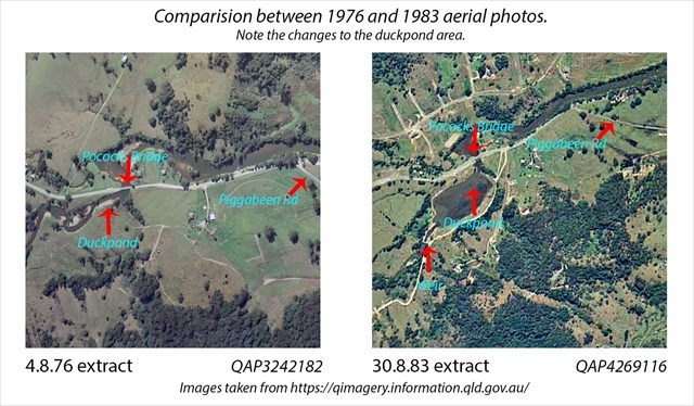
While the 1983 and 1989 aerial photos seem to suggest that a weir was in place by that time, a 1976 aerial shows no suggestion of a weir. Interestingly, only the 1980s photos show the duck pond as we know it today. Earlier images show it as a slightly wider water course but not a lake or pond. What caused the duck pond to 'grow' in the 7 years between photos? Was the formation of the duck pond a result of the weir?
So many questions. We are looking forward the Local Studies Library, in particular, being open for research; then we might be able to find answers to these questions. In the meantime, what is your theory?
Post script: While we have visited the Local Studies Library and consulted many resources, we are no clearer as to why the weir was constructed. Perhaps this is a subject for our next visit to Queensland State Archives. We are still interested in your theories.