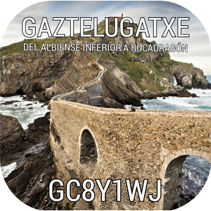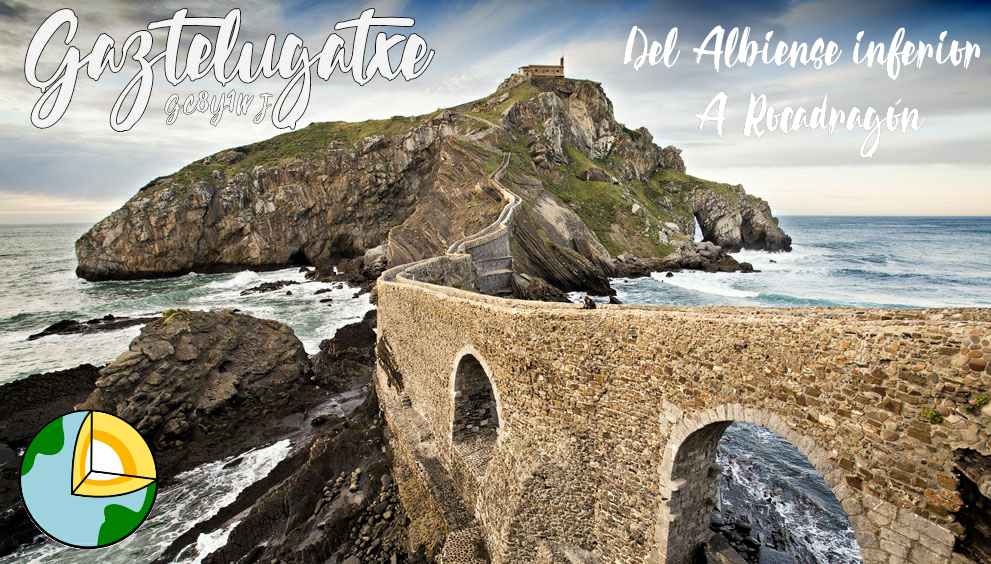
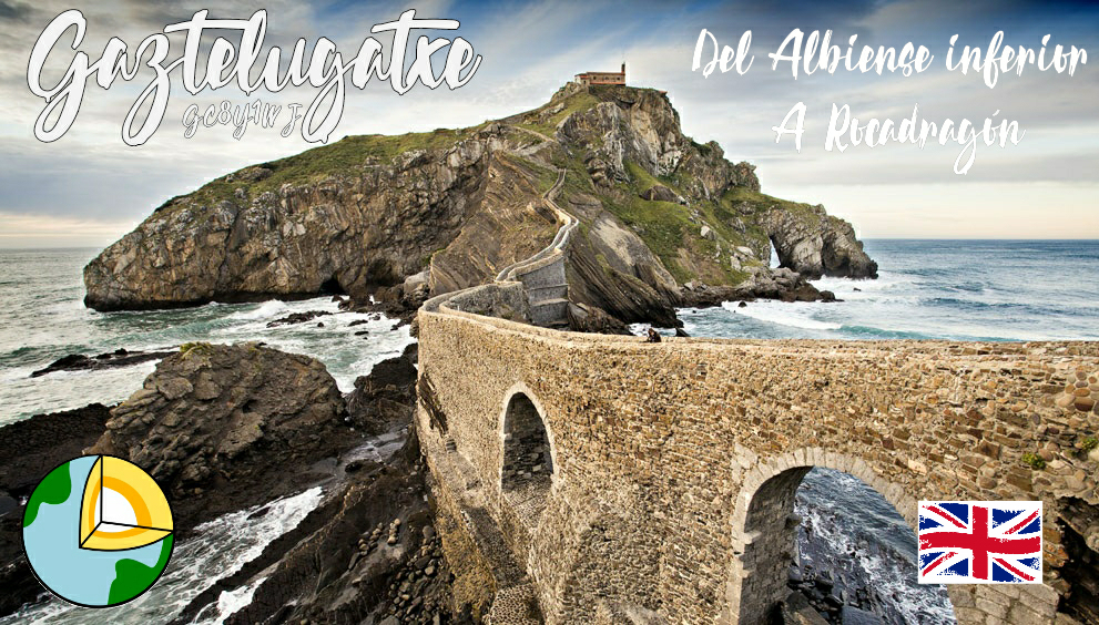
Este earthcaché te lleva a un lugar geológicamente significativo en la costa vasca, en la historia y religión vasca, y más recientemente en la cultural de la de la ficción (literaria y televisiva).
Descripción geológica
El islote de Gaztelugatxe tiene un interés geomorfológico y estratigráfico muy alto. Se observan fenómenos de erosión marina como arcos y la pequeña rasa. Se ve también el contacto entre el material turbidítico en primer plano y el relieve que ofrecen las megabrechas calizas

Gaztelugatxe está constituida por calizas marino someras del Albiense inferior (facies Urgoniano) depositadas en una plataforma carbonatada del margen de placa europeo. Hacia el Albiense inferior-medio dicha plataforma fue afectada por fallas extensivas lo cual colapsó la producción carbonatada provocando el hundimiento de la zona y la creación de series de resedimentación constituidas principalmente por megabrechas calizas.

La unidad de megabrechas de Bakio se dispone discordantemente sobre las calizas de plataforma de San Juan de Gaztelugatxe y representa un episodio de desmantelamiento de la misma en los taludes recién formados por la actividad tectónica así como un hundimiento de la zona que conlleva una subida relativa del nivel del mar.
Posteriormente, ligado al hundimiento progresivo en la zona, se establecen condiciones más profundas en las que se instaura un sistema de abanico turbidítico nutrido por aportes siliciclásticos meridionales que gradualmente hacia techo presenta aportes septentrionales, y que se caracteriza asimismo por facies de grano grueso.

Además del interés estratigráfico, desde el punto de vista geomorfológico, la isla de San Juan de Gaztelugatxe (y Aketxe) representa un enclave singular dado lo escaso que son las islas en esta parte de la costa cantábrica. Se forman por la acción de la dinámica litoral que retrasa progresivamente el acantilado dejando aislados islotes rocosos más resistentes a la erosión. Presenta una fuerte pendiente y elementos geomorfológicos de erosión como arcos y una pequeña rasa. El islote está unido a tierra artificialmente a través de un puente construido sobre las rocas que quedaron entre el islote y el continente. En caso de una perenne marea baja la unión del islote con el continente sería visible a través de las rocas laminadas como nexo de unión.
Así mismo, la carretera Bermeo-Bakio en esta zona está afectada por depósitos de ladera generados por un efecto gravitacional actualmente activo. Este coluvial se nutre del sustrato areniscoso y se compone principalmente de bloques de escala centimétrica a decamétrica que se deslizan por clastos menores englobados en arcillas pedogénicas y en materiales blandos de la unidad de megabrechas.
Historia y leyenda
El uso del nombre de San Juan de Gaztelugatxe se remonta a los siglos XI y XII. En 1053, los señores de Bizkaia donan al famoso monasterio pirenaico el templo de San Juan de Gaztelugatxe. En los documentos de esa época ya se le empieza a conocer como Sancti Johannis de Castiello,. Más tarde, en 1162, se dona a la orden Premonostratense, y entonces es denominado Sanctus Iohannes de Penna. Este nombre, San Juan de la Peña, que ha perdurado a través de los siglos, puede llevar a pensar que se trataba de un retoño del famoso monasterio pirenaico, nacido en lo más abrupto de la costa vizcaína, sobre una fortaleza o castillo previo.

El nombre de San Juan procede de la reliquia de la cabeza del Bautista, que todavía se conserva en el relicario que se da a besar en los grandes días de fiesta. La imagen más venerada del templo es la cabeza de San Juan depositada sobre una bandeja.
El origen del nombre Gaztelugatxe es desconocido. Para intentar aclararlo se hacen las siguientes interpretaciones:
- Gaztelu-gatx: "castillo difícil"
- Gaztelu-aitz: "peña del castillo"
- Castel-ugatx: formado por un primer elemento latinizante castellum-castillo y la palabra ugatx.
Otra denominación popular del santuario es Doniene que seguramente es contracción de Done Iohannes (San Juan).
En cualquier caso, San Juan de Gaztelugatxe es el santuario marítimo más importante de Euskal Herria. Ha sido, a lo largo de los siglos, un lugar de peregrinación de los habitantes de una gran parte de Bizkaia, especialmente de los marineros de los pueblos vecinos.
Los escritores románticos del siglo XIX, coincidiendo con el nacimiento del nacionalismo vasco, lo reivindicaron como un símbolo de la soberanía nacional, rememorando la heroíca defensa que desde lo alto del peñón se hizo de la independencia de Bizkaia.
Para llegar a la misma hay que asceder 231 escalones, aunque la tradición sostiene que antiguamente había tantos peldaños como días tiene el año, o sea 365.

Por el camino nos encontraremos con alguna de las huellas que dejo San Juan Bautista, según cuenta la leyenda, después de desembarcar en el puerto de Bermeo y acceder en sólo tres pasos a este lugar. Por eso era un santo. Además, todavía quedan restos de un vía crucis que va desde abajo hasta la ermita con fecha del año 1891.
Subir a la ermita es todo un esfuerzo, pero el peregrino se verá recompensado pues desde lo alto podrá observar uno de los paraísos naturales más impresionantes de Euskal Herria. Las vistas que hay del mar pero, sobre todo, un buen trozo de acantilado costero son fabulosas.
Allí enseguida nos daremos cuenta de la complicada y, a su vez, interesante evolución geológica de nuestro territorio y de la cantidad de energía que desprende el mar sobre esos acantilados.
San Juan de Gaztelugatxe y Juego de Tronos (spoiler)
San Juan de Gaztelugatxe ha sido uno de los lugares escogidos para recrear Rocadragón. La casa tradicional de los Targaryen que acaba de recuperar Daenerys.
San Juan de Gaztelugatxe aparece en la temporada siete de Juego de Tronos. Aunque ha sido editado con una especie de castillo en el lugar donde se encuentra la ermita. Aun así, es muy fácil reconocer.


A vista de dragón, una emocionada Daenerys, escoltada por Tyrion Lannister, Varys, Missandei y Gusano Gris, desembarca en la playa de Zumaia (GC2X191 FLYCH DE ZUMAIA). Un flysch inconfundible dota a la escena de la ruda pero majestuosa esencia de la sempiterna fortaleza. Pero el arenal no es más que la antesala de Euskal Herria.
Tras unas colosales puertas incrustadas en la piedra y custodiadas por dos dragones de pura roca se abre la escalera de San Juan de Gaztelugatxe para ascender a una fortificación digna de su nombre. Y allí, en lo alto, la Sala Principal y la Cámara de la Mesa Pintada desde donde la Madre de Dragones planeará la conquista del Trono de Hierro.

Información relevante para la visita
Para visitar Gaztelugatxe, con antelación deberás reservar online aquí un ticket de acceso gratuito, durante los siguientes momentos del año:
- Fines de semana desde el 14 de marzo al 14 de junio.
- Puente de marzo (19 al 22 de marzo).
- Diariamente durante la Semana Santa (6 a 19 de abril).
- 1 de mayo.
- Diariamente en verano (del 15 de junio al 20 de septiembre).
- Fines de semana de septiembre y octubre.
- Puentes de octubre (10, 11 y 12) y diciembre (5, 6, 7 y 8).
- 26 y 27 de diciembre.
Horario: de 10:00 a 19:00 horas (Desde el 25 de octubre y hasta final del año la última entrada controlada será a las 17:00 horas).
Toda la información actualiza en el siguiente enlace: web.bizkaia.eus/es/gaztelugatxe
Demuestra que has aprendido
Para dar por encontrado este earthcaché envía las respuestas a paradoxs de las siguientes preguntas.
1. Estando unido San Juan de Gaztelugatxe al continente. ¿Por qué se dice que es un islote?
2. Afirmamos que en San Juan se intuye el contacto entre el material turbidítico y un bloque calizo. Sitúate en las coordenadas, observa a tu alrededor y defiende esta afirmación describiendo el aspecto físico que corresponde cada parte. (Qué tipo de materiales se ven al norte y al sur de tu posición)
3. Gaztelugatxe presenta unos arcos, cuales garras que permiten que el islote se ancle y aferre al mar. Por otro lado, el islote Aketxe tiene su propio capricho rocoso. ¿Qué forma tiene esa estructura tan singular? ¿Cuál crees que es el motivo? Marca la opción correcta:
A. Tiene forma de columna corintia, de grosor homogéneo y con caprichosas formas de estilo corintio en su base, simulando hojas. Esta formación es causada por el efecto de la mar brava sobre este singular pedazo de roca caliza.
B. Tiene forma de columna con base más estrecha, como si fuera una aguja de un tocadiscos. Esta formación está causada por el efecto de la mar brava sobre el islote que ha provocado erosión y desprendimientos.
C. Tiene un aspecto de muro, formado por una lámina vertical, propia de los materiales turbidíticos y curiosamente en posición vertical sobre el mar.
4. Observando las evidencias, marca cuál de las opciones es la correcta en caso de que el nivel del mar descendiera de manera permanente:
A. La unión del islote al continente sería visible mediante la rocas laminadas.
B. La unión del islote sería visible mediante un tómbolo.
C. Salvo que el nivel del mar no descendiera 50 metros de forma permanente no sería posible hablar de una unión visible entre el islote y el continente.
Te animamos a añadir una foto a tu registro en la que aparezcas tu, tu gps o el nombre de tu usuario.
Fuentes de información:
INVENTARIO LUGARES DE INTERÉS GEOLÓGICO EN LA COMUNIDAD AUTÓNOMA DEL PAÍS VASCO
URDAIBAI RESERVA DE LA BIOSFERA
This earthcaché takes you to a geologically significant place on the Basque coast, in Basque history and religion, and more recently in the culture of fiction (literary and television).
Geological description
The islet of Gaztelugatxe has a very high geomorphological and stratigraphic interest. Marine erosion phenomena such as arches and the small rasa are observed. You can also see the contact between the turbiditic material in the foreground and the relief offered by the limestone megabreccias
Gaztelugatxe is made up of shallow marine limestones from the lower Albian (Urgonian facies) deposited on a carbonate platform on the margin of the European plate. Towards the lower-middle Albiense, this platform was affected by extensive faults, which collapsed carbonate production, causing the area to subside and creating series of re-sedimentation, mainly consisting of limestone megabreccias.
The Bakio megabreccia unit is discordantly disposed on the platform limestones of San Juan de Gaztelugatxe and represents an episode of dismantling of the same in the slopes recently formed by tectonic activity as well as a subsidence of the area that entails a relative rise in the sea level.
Later, linked to the progressive subsidence in the area, deeper conditions are established in which a turbiditic fan system is established nourished by southern siliciclastic contributions that gradually towards the ceiling presents northern contributions, and which is also characterized by coarse-grained facies.
In addition to its stratigraphic interest, from a geomorphological point of view, the island of San Juan de Gaztelugatxe (and Aketxe) represents a unique enclave given the scarcity of islands in this part of the Cantabrian coast. They are formed by the action of the littoral dynamics that progressively slows down the cliff, leaving isolated rocky islands more resistant to erosion. It has a steep slope and geomorphological elements of erosion such as arches and a small level. The islet is artificially attached to land through a bridge built on the rocks that remained between the islet and the mainland. In the event of a perennial low tide, the union of the islet with the mainland would be visible through the laminated rocks as a connecting link.
Likewise, the Bermeo-Bakio highway in this area is affected by slope deposits generated by a currently active gravitational effect. This colluvial feeds on the sandstone substrate and is mainly composed of blocks of centimeter to decametric scale that slide through smaller clasts encompassed in pedogenic clays and in soft materials of the megabreccia unit.
History and legend
The use of the name of San Juan de Gaztelugatxe dates back to the 11th and 12th centuries. In 1053, the lords of Bizkaia donated the San Juan de Gaztelugatxe temple to the famous Pyrenean monastery. In the documents of that time, he is already known as Sancti Johannis de Castiello ,. Later, in 1162, it was donated to the Premonostrate order, and then it was named Sanctus Iohannes de Penna. This name, San Juan de la Peña, which has endured through the centuries, may lead us to think that it was an offshoot of the famous Pyrenean monastery, born in the steepest part of the Biscayan coast, on a previous fortress or castle.
The name of San Juan comes from the relic of the head of the Baptist, which is still preserved in the reliquary that is given to kiss on the great holidays. The most venerated image in the temple is the head of Saint John placed on a tray.
The origin of the name Gaztelugatxe is unknown. To try to clarify it, the following interpretations are made:
- Gaztelu-gatx: "difficult castle"
- Gaztelu-aitz: "rock of the castle"
- Castel-ugatx: formed by a first latinizing element castellum-castle and the word ugatx.
Another popular denomination of the sanctuary is Doniene that surely is contraction of Done Iohannes (San Juan).
In any case, San Juan de Gaztelugatxe is the most important maritime sanctuary in Euskal Herria. It has been, over the centuries, a place of pilgrimage for the inhabitants of a large part of Bizkaia, especially the sailors from neighboring towns.
The romantic writers of the 19th century, coinciding with the birth of Basque nationalism, claimed it as a symbol of national sovereignty, recalling the heroic defense that from the top of the rock was made of the independence of Bizkaia.
To get there, you have to climb 231 steps, although tradition holds that in the past there were as many steps as there are days in the year, or 365.
On the way we will find some of the footprints left by San Juan Bautista, according to legend, after disembarking at the port of Bermeo and accessing this place in just three steps. That's why he was a saint. In addition, there are still remains of a Stations of the Cross that goes from below to the hermitage dated 1891.
Going up to the hermitage is quite an effort, but the pilgrim will be rewarded because from the top they will be able to observe one of the most impressive natural paradises in Euskal Herria. The views of the sea but, above all, a good piece of coastal cliff are fabulous.
There we will immediately realize the complicated and, in turn, interesting geological evolution of our territory and the amount of energy that the sea gives off on these cliffs.
San Juan de Gaztelugatxe and Game of Thrones (spoiler)
San Juan de Gaztelugatxe has been one of the places chosen to recreate Dragonstone. The traditional Targaryen house that Daenerys just recovered.
San Juan de Gaztelugatxe appears in season seven of Game of Thrones. Although it has been edited with a kind of castle in the place where the hermitage is located. Even so, it is very easy to recognize.
From a dragon's eye, an excited Daenerys, escorted by Tyrion Lannister, Varys, Missandei and Gray Worm, lands on the beach in Zumaia (GC2X191 FLYCH DE ZUMAIA). An unmistakable flysch endows the scene with the rugged but majestic essence of the everlasting fortress. But the sandy area is nothing more than the prelude to Euskal Herria.
After some colossal doors embedded in the stone and guarded by two dragons of pure rock, the staircase of San Juan de Gaztelugatxe opens to ascend to a fortification worthy of its name. And there, at the top, the Main Hall and the Chamber of the Painted Table from where the Mother of Dragons will plan the conquest of the Iron Throne.
Relevant information for the visit
To visit Gaztelugatxe, in advance you must book a free access ticket online here, during the following times of the year:
- Weekends from March 14 to June 14.
- March bridge (March 19-22).
- Daily during Holy Week (April 6 to 19).
- May 1st.
- Daily in summer (from June 15 to September 20).
- Weekends in September and October.
- Bridges of October (10, 11 and 12) and December (5, 6, 7 and 8).
- December 26 and 27.
Hours: from 10:00 a.m. to 7:00 p.m. (From October 25 until the end of the year, the last controlled entry will be at 5:00 p.m.).
All the information is updated at the following link: web.bizkaia.eus/es/gaztelugatxe
Show that you have learned
To find this earthcache, send the answers to paradoxs of the following questions.
1. San Juan de Gaztelugatxe being attached to the continent. Why is it said to be an islet?
2. We affirm that in San Juan the contact between the turbiditic material and a limestone block is sensed. Situate yourself in the coordinates, look around you and defend this statement by describing the physical aspect that corresponds to each part. (What kind of materials do you see north and south of your position)
3. Gaztelugatxe has arches, which claws that allow the islet to anchor and cling to the sea. On the other hand, the Aketxe islet has its own rocky quirk. What is the shape of this unique structure? What do you think is the reason?
Check the correct option
A. It is shaped like a Corinthian column, of homogeneous thickness and with whimsical Corinthian-style shapes at its base, simulating leaves. This formation is caused by the effect of the rough sea on this unique piece of limestone rock.
B. It is shaped like a column with a narrower base, like a needle on a record player. This formation is caused by the effect of the rough sea on the islet that has caused erosion and landslides.
C. It has the appearance of a wall, formed by a vertical sheet, typical of turbidite materials in a vertical position on the bar.
4. Looking at the evidence, mark which of the options is correct in case the sea level drops permanently.
A. The union of the islet to the continent would be real by means of the laminated stone.
B. The union of the islet would be real by means of a tombolo.
C. Unless the sea level did not drop 50 meters permanently, it would not be possible to speak of a visible union between the islet and the continent.
We encourage you to add a photo to your registry in which you, your GPS or the name of your user appear.
Information sources:
INVENTARIO LUGARES DE INTERÉS GEOLÓGICO EN LA COMUNIDAD AUTÓNOMA DEL PAÍS VASCO
URDAIBAI RESERVA DE LA BIOSFERA