
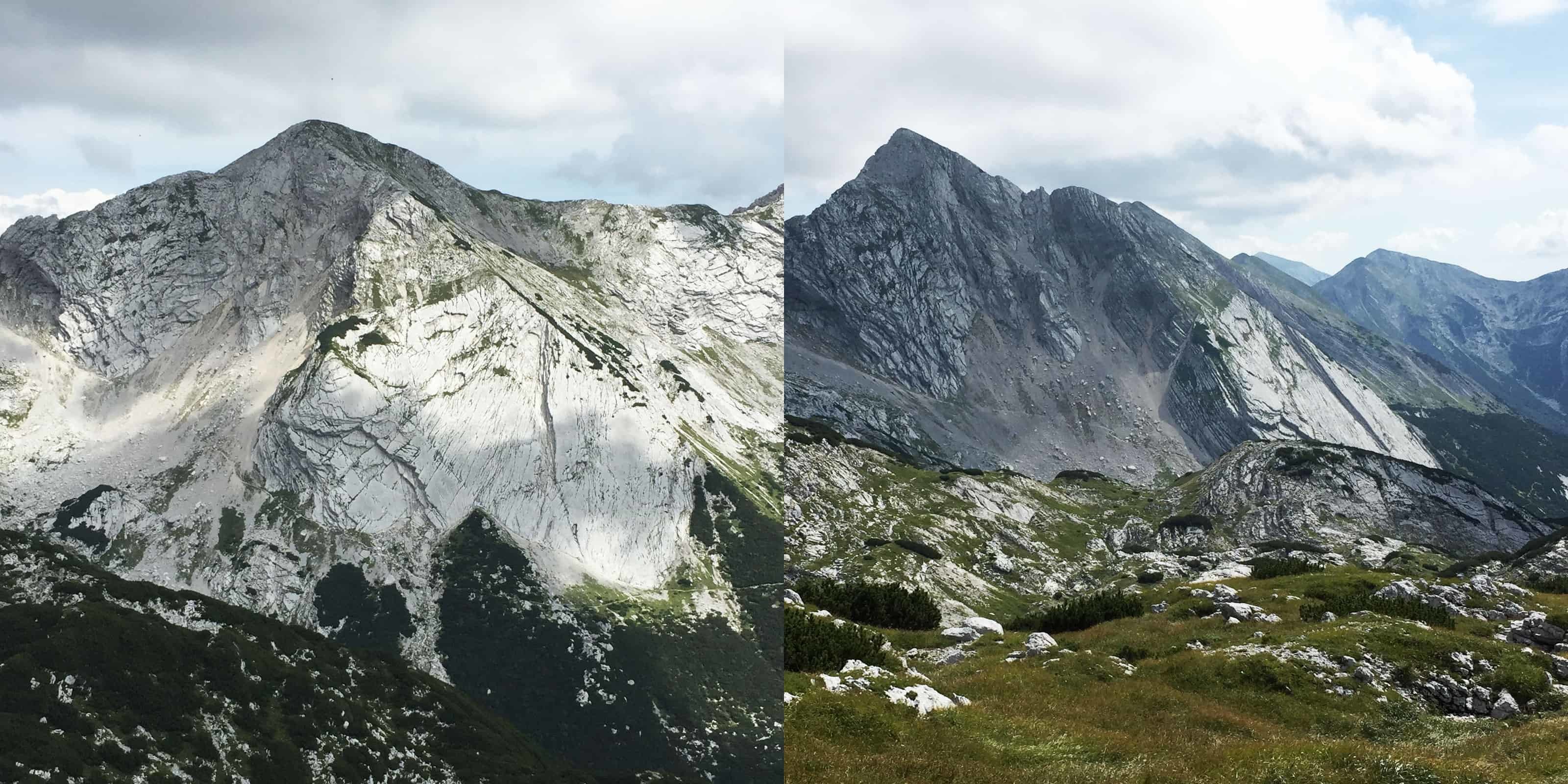
Vrh nad Škrbino (2054 m) ni najvišji, a je glede na obliko in veličino po mnenju avtorjev mojega že precej zdelanega vodnika Julijske Alpe (Planinska zveza Slovenije 1978) najpomembnejši vrh verige Spodnjih Bohinjskih gora. Pohodnikom, ki se nanj podajo s primorske strani, pade v oči nenavadna ploščata jugozahodna stena. Od daleč je videti, kot da bi skladoviti dachsteinski apnenec s plastmi in vložki dolomita, ki prevladuje v tem delu verige, nekdo (zelo velik) gladko odrezal z (zelo velikim) nožem.
Vrh nad Škrbino in Škrbinska plošča. Na posnetku od strani je lepo vidna plastovitost terena.
Škrbina Pass Peak and Škrbina Plate. Layered rock is visible on the side view.
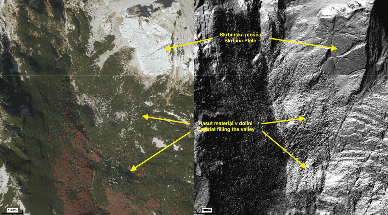
Stena, ki ji pravijo Škrbinska plošča, je v celoti najlepše vidna z vrha Tolminskega Migovca. Ob vznožju na višini približno 1600-1650 m je široka kakih 300 m, v osrednjem delu je visoka dobrih 200 m. Da bi jo nekdo odrezal z nožem ni prav verjetno. Na posnetku iz zraka je vidno, da je material, ki manjka na pobočju, zasul spodnji del doline pod Migovcem. Škrbinska plošča je torej ostanek procesa, ki je pred davnimi leti spremenil videz južnega pobočja gore. Leta 1950 so podoben proces v živo opazovali zgroženi vaščani Jablanice v pobočju Javorščka (res je, to je tisto, kar vsakič opazujete iz Bovca, zdaj pa končno veste, za kaj gre).
Posnetek iz zraka in LIDAR posnetek lepo prikažeta nasutje materiala v dolinici pod Migovcem.
Aerial and LIDAR view reveal the material that filled the valley under Migovec.
Pobočni procesi oziroma zemeljski plazovi
V najširšem smislu (kot ga zajema angleški izraz landslide) pomeni zemeljski plaz premik gmote kamenja, prsti, preperine ali drugega materiala s polzenjem, plazenjem, padanjem ali tokom. Terminologija in opredelitve so precej neenotne, v (slovenski) geografiji te procese označujemo s skupnim imenom pobočni procesi. Pobočni procesi v pokrajini povzročajo spremembe na mestu nastanka, na območju potovanja gradiva in na območju odlaganja ali akumulacije. V mnogih, tudi domačih virih je pogosto povzeta prirejena razvrstitev zemeljskih plazov po Varnesu iz leta 1978.
Razvrstitev zemeljskih plazov oziroma pobočnih procesov (prirejeno po Varnes 1978)

Plazenje je proces, v katerem se gradivo se pomika v blokih. Značilno je za preperino in nesprijete sedimente ter trdne kamnine. Pri tem gre lahko za rotacijski ali translacijski zemeljski plaz (gmota zdrsne po pobočju po eni ali več drsnih ploskvah, večina gmote ostane nepremešane) ali kamniti zdrs (zdrs trdne kamnine po eni ali več neveznostih, npr. po plastovitosti; kasneje zaradi konfiguracije pobočja ponavadi preide v padanje).
Padanje je proces, v katerem gradivo prosto pada v zraku ali se prevrača po pobočju. Značilno je za trdne kamnine. Če je količina padlega materiala velika, se imenuje skalni podor (glej GC41G8E), če gre za posamezne skale, pa skalni odlom.
Tok pa je proces, v katerem se delci materiala pomikajo po pobočju neodvisno drug od drugega in ne kot sprijeta gmota. Tok je značilen za nesprijete sedimente in preperino. Glede na vsebnost vlage in vrsto/velikost delcev gre lahko za polzenje, kamniti tok, preperinski tok, drobirski tok (glej GC39WA9),...
Bočni razmik je posebna vrsta, značilna za manj strma pobočja ali celo pretežno ravninske predele.
Pobočni procesi so seveda lahko tudi kombinirani.
Naloge za vpis najdbe
1. Za kakšno vrsto pobočnega procesa je šlo pri nastanku Škrbinske plošče? Utemeljite svoj odgovor.
2. Proces je razkril golo skalo, ki dotlej ni bila izpostavljena zunanjim vplivom (predvsem vremenskim). Sčasoma pa je zakrasela. Oglejte si spodnji del stene na EC točki. Katere kraške pojave lahko opazite v skali?
3. Na točki 1 boste opazili šolski primer nekega kraškega pojava. Za kakšen pojav gre in kako se razlikuje od podobnega pojava na Škrbinski plošči? Kako bi lahko pojasnili razliko?
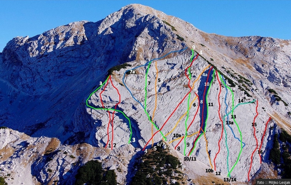
4. Škrbinska plošča je zelo priljubljena med plezalci, saj so v njej speljane številne plezalne smeri. Oglejte si steno, jo otipajte, morda celo (previdno!) splezajte po njej kak meter ali dva. Zaradi katerih lastnosti je po vašem stena zelo primerna za plezalce začetnike?
5. Fotografije, ki ne razkrivajo odgovorov, so dobrodošle, a niso obvezne.
POMEMBNO!
- Preden vpišete najdbo zaklada, pošljite odgovore preko GC profila ali neposredno na e-naslov icabrian@geocacher.si. Takoj potem lahko vpišete najdbo zaklada na spletu, dodatnega dovoljenja ne potrebujete.
- Vpisi brez ustrezne spremljajoče e-pošte, ki vsebuje pravilne odgovore, bodo najprej trajno kodirani, kasneje izbrisani!
- Vpisi, ki vsebujejo odgovor bodo izbrisani!
Dostop
Ena ura hoje od koče na Planini Razor, do katere pridete s tolminske strani z enega od označenih parkirišč. Dostop z bohinjske strani čez Škrbino zahteva znatno več hoje. Glej opis v vodnikih ali na hribi.net za podrobnosti.

Škrbina (Slovene word for a stub) is a mountain pass at 1910 m. It has been used as a connection from Bohinj to the Littoral region since the iron age times. Škrbina Pass Peak (Vrh nad Škrbino, 2054 m) may not be the highest in the Lower Bohinj Mountains. According to the authors of my worn out guide Julian Alps (Alpine Association of Slovenia 1978), however, its appearance and grandness make it the most important in the chain. Hikers, who approach Škrbina pass from the south, never fail to notice the unusual wall in the southwestern face of the mountain. From a distance, it looks as if someone (very big) had cut the slope of layered Dachstein limestone with layers of dolomite (predominant type of rock in the chain) clean with a (very big) knife.
Številne plezalne smeri v Škrbinski plošči.
Many climbing routes span the Škrbina Plate.
The wall, called Škrbina Plate, is best observed in its entirety from the opposite summit of Tolminski Migovec. At the foot at the altitude of 1600-1650 m, it is approximately 300 m wide, its height in the central section is approximately 200 m. It is highly unlikely that it had been cut with a knife. An aerial view reveals that much of the material, missing in the slope, has filled the narrow valley under Tolminski Migovec (see the photos above). Škrbina Plate is thus the result of a process that changed the southern face of the mountain many years ago. The same process was witnessed live in 1950 by the horrified villagers of Jablanica in the slope of Javoršček (yes, it is exactly what you noticed above Bovec and were afraid to ask what it is).
Landslides and slope processes
The term »landslide« describes a wide variety of processes that result in the downward and outward movement of slope-forming materials including rock, soil, artificial fill, or a combination of these. The materials may move by falling, toppling, sliding, spreading, or flowing. In Slovene geography and geology, these processes are covered by a general term »slope process«. These processes transform the landscape on the site of origin, along the course of downslope movement, and on the site of deposition or accumulation of the material. Figure below schematically illustrates the major types of landslide movement (slope processes) as classified by Varnes in 1978.
Classification of landslides (slope processes) by Varnes, 1978

The more restrictive use of the term landslide refers only to mass movements, where there is a distinct zone of weakness that separates the slide material from more stable underlying material. The two major types of slides are rotational slides and translational slides. Block slide is a type of translational slide, in which the moving mass consists of a single unit or a few closely related units that move downslope as a relatively coherent mass (depending on the configuration of the slope, it might transform to a rockfall).
Falls are abrupt movements of masses of geologic materials, such as rocks and boulders, that become detached from steep slopes or cliffs (see GC41G8E). Separation occurs along discontinuities such as fractures, joints, and bedding planes, and movement occurs by free-fall, bouncing, and rolling.
Flows are processes, where material particles are moving downslope cohesionless and not as a coherent mass. Depending on the type of material, flow speed, moisture/water saturation and other factors there are several fundamentally different flow categories, such as debris flow (see GC39WA9), debris avalanche, earthflow, mudflow and creep.
Lateral spreads are distinctive because they usually occur on very gentle slopes or flat terrain. The dominant mode of movement is lateral extension accompanied by shear or tensile fractures.
Combination of two or more of the above types is known as a complex landslide.
Logging tasks
1. What type of landslide resulted in the formation of Škrbina Plate? Elaborate your answer.
2. Karstification has transformed the newly uncovered bare rock that hadn't been exposed to natural elements before the event. Observe the base of the Plate at the header coordinates. What types of Karst features can you recognize in the rock?
3. At Waypoint 1, you can find a textbook example of a Karst feature type. What type of Karst feature is found here, and how does it differ from the similar type on Škrbina Plate? What could be an explanation of the difference?
4. Škrbina Plate is popular among climbers, and many climbing routes span the wall. Observe and touch the rock, maybe even (very carefully!) climb up a meter or two. What characteristics of the rock make Škrbina Plate especially suitable for beginners?
5. Photos of your adventure that don't reveal the answers are very welcome, but not mandatory.
Important
- Send answers through GC profile or directly to e-mail icabrian@geocacher.si before logging. After that you can log - you don't need an additional permission to log.
- Logs without an accompanying e-mail containing correct answers will be encrypted and later deleted!
- Logs containing the answer will be deleted!
Access
One hour from the Planina Razor mountain hut, which can be reached from designated parkings on the Tolmin side of the mountain (referred by attributes). Hike from Bohinj side over Škrbina Pass is considerably longer. See hiking guides or hribi.net website for details.
Viri / References
- M. Zorn, B. Komac. Zemeljski plazovi v Sloveniji. Založba ZRC Ljubljana, 2008.
- Reading: Landslide Types and Processes (https://courses.lumenlearning.com/geology/chapter/reading-landslide-types-and-processes/)