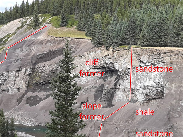
The Ram River valley is made up of layers of sandstone and shale. They erode at different rates.
The sandstone-
A cliff-former is a geological unit of bedrock that is more resistant to erosion than overlying or underlying strata and consequently produces outcrops with high slope angles. It is more or less equivalent to a ridge-former, and may be contrasted with slope-former. In humid environments, sandstones are typically cliff-formers. In arid environments, limestones are often cliff-formers also. Recent lavas may be cliff-formers as well.
The shale-
A slope-former is a unit of bedrock which is less resistant to erosion than overlying or underlying units and consequently results in outcrops with low relative slope angles. It may be contrasted with a cliff-former. Typical slope forming lithologies include shales, and limestones in humid environments.
Wind, rain/river (water), thaw and freeze cycles, etc. all contribute to the erosion of the different sedimentary layers along the Ram River. The cretaceous sandstones form the cliffs due to their ability to resist the erosion process. The cretaceous shales are far less resistive and create the slopes. In the end, they will succumb to the forces of the Ram River.
Earthcache requirements:
Send the CO the answers to the following questions. Do not post them in your log.
- Estimate the height in meters of the river bank across the river form GZ.
- Estimate the height of the cliff-former layers.
- Estimate the angle of the slope-former layer at the bottom of the river valley.
- What forms of erosion do you see across the river? Don’t limit yourself to the ones listed above.
- Post a picture of you or your GPS at GZ.
Failure to fulfill the requirements will result in deletion of you Found It log.