Español
Localización
El río Duratón, desde su nacimiento en las proximidades del Puerto de Somosierra (Madrid-Segovia), atraviesa muy diferentes configuraciones paisajísticas en su discurrir hacia Peñafiel (Valladolid), donde desemboca en el río Duero por su margen izquierda. De todas ellas, destacan por su espectacularidad aquéllas en las que el río es partícipe principal en la evolución morfológica, generando valles, gargantas u hoces, que contrastan con la habitual uniformidad de la meseta castellana.
Sin duda alguna, los parajes más peculiares se localizan en las zonas en las que el río atraviesa litologías carbonáticas (calizas, dolomías, margas...) donde, por la naturaleza de éstas, la verticalidad de las paredes del valle contrasta notablemente con su fondo plano
Las Hoces del Duratón surcan de Este a Oeste, y luego de SE a NO el denominado Macizo de Sepúlveda, donde afloran principalmente materiales del Cretácico superior, con dos conjuntos de rocas: uno inferior terrígeno (cuarzoarenitas y arcillas), y uno superior carbonático (calizas, dolomías y margas) de origen marino
Origen
El valle se ha formado por el progresivo encajamiento del río Duratón en las superficies de las lastras, es decir, el río ha ido erosionando las rocas de su lecho a lo largo de los últimos dos millones de años, excavando una especie de gran zanja.
Para entender esta enorme capacidad erosiva del río hay que tener en cuenta dos aspectos:
A) Que las rocas que forman las lastras (calizas y dolomías) son parcialmente solubles en agua mediante la denominada acción kárstica, con lo que el lecho del río ya estaba previamente ‘agujereado’ por pequeñas cuevasy dolinas, cuyo hundimiento facilitaba la tarea erosiva del río
B) La enorme magnitud temporal de la que estamos hablando (unos dos millones de años), que reduce la tasa media de encajamiento del valle en las lastras circundantes (unos 200 m como máximo en la zona de Villar de Sobrepeña) a la insignificante cifra de una décima de milímetro por año.
Esa cifra media de velocidad de encajamiento del valle del Duratón en las lastras es engañosa, puesto que dicha incisión se produjo en dos etapas claramente diferenciadas: una etapa inicial en la que el Duratón formó un primer valle ancho y poco profundo (paleovalle); y una etapa final, que aún continúa, en la que ha sufrido un rápido y profundo encajamiento de más de 60 m, formando el cañón propiamente dicho (estrecho y de paredes verticalizadas), que ocupa una estrecha banda serpenteante del lecho del antiguo paleovalle
1) La orogenia alpina formó en las calizas cretácicas un gran pliegue ‘en rodilla’ con dirección E-O.
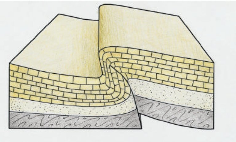
2) El río Duratón erosionó la zona de máxima curvatura del pliegue (denominada charnela) al ser la más fracturada, formando un paleovalle rectilíneo (con dirección ligeramente oblicua al pliegue), al que desembocaban con normalidad los afluentes de la margen derecha
3) Finalmente, se produce el rápido encajamiento del cañón en el lecho del paleocauce, con trazado meandriforme, dejando colgados los valles laterales de los afluentes y restos del antiguo valle
No se sabe con certeza cuándo se produjo el cambio en la modalidad de incisión del valle, pero estuvo motivado por una de estas dos causas:
1) O bien se produjo un ligero levantamiento tectónico de las rocas del Macizo
2) O bien se produjo un repentino descenso del nivel de mares y océanos durante uno de los periodos glaciares del Cuaternario, que hizo descender el nivel del lecho del río Duero, y en consecuencia de todos sus afluentes, entre ellos la cota de desembocadura del Duratón.
No se descarta que lo que en realidad haya ocurrido en la formación del Cañón del Duratón sea una combinación de los dos fenómenos
Valles colgados
El resultado de ambas fases de encajamiento ha sido que, a partir de la parte culminante de los relieves estructurales en los materiales cretácicos (lastras, mesas y escarpesde cuesta), se ha producido durante el Cuaternario el progresivo encajamiento de la red fluvial, formando algunos de los elementos que hoy se reconocen en el paisaje: un cuenco ancho, algo desdibujado, en la parte superior del valle, donde se reconocen retazos de lecho del antiguo paleovalle, allí donde el encajamiento posterior del cañón no lo ha desmantelado; el cañón actual de paredes verticalizadas; y los vallejos y barrancos de los torrentes afluentes laterales, que forman gargantas y hocinos en las lastras y el paleovalle, y que quedan ‘colgados’, formando cascadas en sudesembocadura al Duratón, cuando alcanzan el cañón, dejando en las paredes muescas con perfil de V ó U.
Esta singularidad de los afluentes colgados es fácilmente reconocible en las desembocaduras de barrancos en el entorno de la ermita de San Frutos, y se ha justificado por dos circunstancias: el rápido encajamiento del cañón principal, hace que los vallejos afluentes, con menor caudal (prácticamente secos todo el año), no sean capaces de incidir en su lecho a la misma velocidad que el Duratón
Para registrar este earthcache, enviame um correoeletrónico com la respuesta a las seguintes preguntas:
1) ¿Cuales son los aspectos que mas han influido en la capacidad erosiva del rio ? ¿ En cuantas fases se formo este valle ?
2) En las coordenadas iniciales, ¿ que tipo de roca podemos ver ? ¿Que color o colores podemos ver?
3) En WP2: En una de las paredes podemos ver un valle colgado, de espaldas a la iglesia, ¿ de que lado esta ? ¿ llega al fondo?
4) ¿Por que razones este valle no se ha erosionado igual que el del Duratón?
5) Añade una fotografia tuya en uno de los dos locales, u otra en la que se pueda ver algún objeto tuyo, o tu nick en un papel
-Si crees que as concluido con exito los objetivos de este Earth Cache, y me ha enviado todas las respuestas solicitadas, puede hacer el log. Luego yo comprobaré que son correctas, y si hay cualquier problema me pondre en contacto para arreglarlo.
-Logs sin respuestas enviadas previamente, seran borrados sin aviso
English (google translate)
Location
The Duratón River, from its source near the Port of Somosierra (Madrid-Segovia), crosses very different landscape configurations in its course towards Peñafiel (Valladolid), where it flows into the Duero River on its left bank. Out of all of them, those in which the river is the main participant in the morphological evolution, generating valleys, gorges or gorges, which contrast with the usual uniformity of the Castilian plateau, stand out for their spectacularity.
Without a doubt, the most peculiar places are located in the areas where the river crosses carbonatic lithologies (limestones, dolomites, marls ...) where, due to their nature, the verticality of the valley walls contrasts notably with their flat bottom
Las Hoces del Duratón furrow from East to West, and then from SE to NW the so-called Sepúlveda Massif, where mainly materials from the Upper Cretaceous surface, with two sets of rocks: a lower terrigenous one (quartz-sand and clays), and an upper carbonate ( limestones, dolomites and marls) of marine origin
Origin
To understand this enormous erosive capacity of the river, two aspects must be taken into account:
A) That the rocks that form the ballast (limestones and dolomites) are partially soluble in water through the so-called karst action, with which the river bed was previously 'bored' by small caves and sinkholes, whose sinking facilitated the erosive task of the River
B) The enormous temporal magnitude we are talking about (about two million years), which reduces the average rate of embedding of the valley in the surrounding slopes (about 200 m at most in the Villar de Sobrepeña area) to an insignificant figure of a tenth of a millimeter per year. This average figure for the speed of fitting of the Duratón valley into the slabs is misleading, since said incision occurred in two clearly differentiated stages: an initial stage in which the Duratón formed a first wide and shallow valley (paleovalle); and a final stage, which is still continuing, in which it has undergone a rapid and deep embedding of more than 60 m, forming the canyon itself (narrow and with vertical walls), which occupies a narrow meandering band of the bed of the old paleovaley
1) The alpine orogeny formed in the cretaceous limestones a large ‘knee’ fold in an E-W direction.
2) The Duratón River eroded the area of maximum curvature of the fold (called hinge) as it was the most fractured, forming a rectilinear paleovalle (with a slightly oblique direction to the fold), to which the tributaries of the right bank flowed normally
3) Finally, the rapid fitting of the canyon into the bed of the paleocauce occurs, with a meandering pattern, leaving the lateral valleys of the tributaries and remains of the old valley hanging.
It is not known with certainty when the change in the incision modality of the valley occurred, but it was motivated by one of these two causes:
1) Or there was a slight tectonic uplift of the rocks of the Massif
2) Either there was a sudden drop in the level of the seas and oceans during one of the glacial periods of the Quaternary, which lowered the level of the bed of the Duero River, and consequently of all its tributaries, including the mouth of the river. Duraton.
It is not ruled out that what actually happened in the formation of the Duratón Canyon is a combination of the two phenomena
Hanging valleys
The result of both interlocking phases has been that, starting from the culminating part of the structural reliefs in the Cretaceous materials (ballasts, mesa and escarpment slopes), the progressive interlocking of the river network has occurred during the Quaternary, forming some of the elements that are recognized today in the landscape: a wide bowl, somewhat blurred, in the upper part of the valley, where remnants of the bed of the old paleovalle are recognized, there where the posterior fitting of the canyon has not dismantled it; the current canyon with verticalized walls; and the valleys and ravines of the lateral tributary streams, which form gorges and snouts in the slopes and the paleovalle, and which remain 'hanging', forming waterfalls at its mouth to the Duratón, when they reach the canyon, leaving notches in the walls with the profile of V or U.
This singularity of the hanging tributaries is easily recognizable in the mouths of ravines in the surroundings of the hermitage of San Frutos, and has been justified by two circumstances: the rapid fitting of the main canyon, makes the tributary valleys, with less flow (practically dry all year), are not able to affect its bed at the same speed as the Duratón
To log this earthcache, send me an email /message with the answer to the following questions:
1) What are the aspects that have most influenced the erosive capacity of the river? In how many did this valley form?
2) In the initial coordinates, what kind of rock can we see? What color or colors can we see?
3) In WP2: On one of the walls we can see a hanging valley, with our back to the church, on which side is it? Does it get to the bottom?
4) For what reasons has this valley not eroded like that of Duratón?
5) Add a photo of yourself in one of the two locations, or another in which you can see an object of yours, or your nick on a piece of paper
-If you believe you have successfully completed this Earth Cache goals and has already sent to me all the requirements as requested, Please, feel free to log it as found. Later i will verify the requirements sent and, if necessary, contact you in order to make the necessary corrections to your log.
-Logs without answers, will be deleted without notice.
Sources:
"Así se formaron las Hoces del Duratón”, Instituto Geológico y Minero de España (IGME)
|