TUNEL DE LA FONT DE SOPALMO
"SUFOSIÓN, TUBIFICACIÓN O PIPING"

Este túnel está ubicado en el término municipal de Ibi, más concretamente en la partida de Sopalmo. Está situado en el barranco de Gavarnera, a pocos metros más arriba de la fuente del Sopalmo, al SurEste del casco urbano de Ibi.
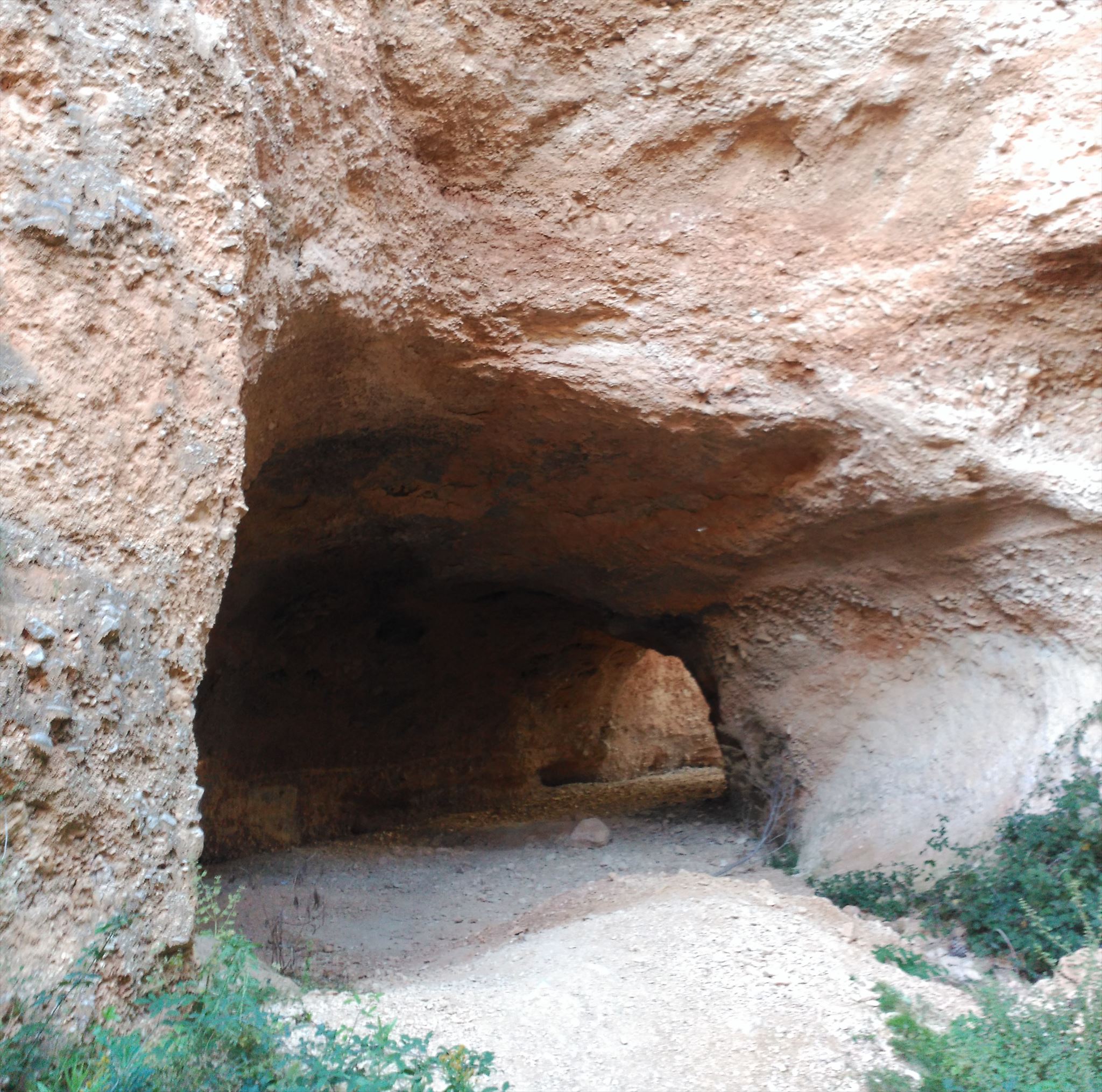 Es un túnel de XX m. de recorrido con sección de A x B m. Su formación es debida a la acción del agua que ha ido erosionando las gravas y arenas menos compactas abriéndose paso por ellas.
Esta cavidad tiene su historia y, si bien su formación es debida a la acción de la erosión torrencial del agua, el origen de su nacimiento pudo ser debido a la acción del hombre, según una leyenda local.
Según la leyenda el barranco quedaba cortado en un angosto y profundo barranco saltando sus aguas por encima de los bancales e inundándolos (Zona del Sopalmo). A finales del siglo XIX el dueño de aquella zona se le ocurrió hacer una pequeña presa cuyas aguas fueron canalizadas abriendo un pequeño túnel canalizado hasta la parte opuesta distante más de 50 m. en donde continuaba el barranco tras haber saltado sobre la superficie inundando los bancales. Aquella obra fue bien mientras las aguas bajaban mansas, pero las fuertes avenidas penetraron con dureza en el pequeño túnel hasta que abandonada la zona, las aguas iniciaron un proceso de erosión libre de impedimentos formando en la actualidad el gran túnel del Sopalmo.
NOTA: Sopalmo: significa zona de riego o inundación
=> ¿CÓMO SE FORMO EL TUNEL DE SOPALMO?
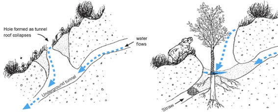
El Túnel de la Font de Sopalmo, es una consecuencia de una escorrentía superficial interceptada por las grietas de desecación, galerías de animales, u otras aberturas, tanto en la vertiente como en un depósito de fondo del valle. El agua penetra hasta que encuentra una capa de alta porosidad, o con una abertura en el subsuelo, o bien es bloqueada por una capa impermeable. El flujo remueve las partículas del terreno, agrandando la abertura o conducto gradualmente, como un túnel y ese proceso erosión da la formación al túnel.
Este proceso se denomina SUFOSIÓN, TUBIFICACIÓN O “PIPING”.
=> ¿QUE ES EL SUFOSIÓN , TUBIFICACIÓN O “PIPING”.?
El término sufosión procede del latín suffossio, que significa excavar por debajo. Sin embargo, el término tubificación o en inglés piping (de pipe, tubería) está mucho más extendido. Podemos definir este concepto como “la formación de conductos (pipes) naturales en el suelo u otros depósitos no consolidados por elevación o por procesos de erosión diferencial subsuperficial”.
Constituye un conjunto de procesos geomorfológicos actuales muy activos en las formaciones sedimentarias blandas del Sureste de la Península Ibérica semiárido. Numerosos factores y mecanismos pueden intervenir en el desarrollo de conductos, tubos, túneles y galerías; la amplia diversidad de formas y variedad de escalas a las que se encuentran parece confirmarlo. Las teorías acerca de la naturaleza y génesis de los suelos con Sufosión, Tubificación o Piping, son muchas .
La tipo de erosión es un proceso azonal, ya que se encuentra en todos los regímenes climáticos; pero es en las zonas secas, preferentemente semiáridas, donde alcanza un mayor grado de desarrollo. Esto se debe a tres causas: la necesidad de un agrietamiento por desecación que favorece el inicio del piping, la presencia de lluvias torrenciales esporádicas que alimentan los canales, túneles y evacúan el material a favor de fuertes pendientes, y la presencia de una vegetación de tipo estepario, que favorece el desarrollo del proceso.
En síntesis, la mayor parte de los trabajos sugieren como factores que intervienen en su desarrollo inicial, de este tipo de erosión, los siguientes:
1.- Condiciones climáticas semiáridas, en concreto la cantidad y régimen de lluvias. Las esporádicas e intensas lluvias de tormenta alimentan rápidamente los conductos y evacúan el material. Son, pues, necesarios, los importantes gradientes hidráulicos que suministran las lluvias de tormenta.
2.- Amplios periodos sin lluvias y cálidos que desequen y agrieten los materiales finos.
3. Textura y estructura del suelo. La susceptibilidad a ciertos fenómenos físicos y químicos tales como la pérdida de cohesión, dispersión y perforación que ofrecen los suelos con altos contenidos en arcilla y limo y, en particular, con elevada proporción de arcillas hinchables como la montmorillonita, illita y bentonita.
4.- Diferente erodabilidad y permeabilidad de los materiales no cohesivos en las diferentes capas del suelo y subsuelo.
5.- Suelos con alto contenido en sales solubles que ofrezcan una capacidad de cambio de bases elevada, particularmente con el sodio. La percolación del agua y el lavado correlativo del sodio, acarrea la dispersión del material y su fácil remoción y transporte por las escorrentías subsuperficiales.
6.- La vegetación degradada y regresiva favorece los procesos anteriores.
7.- Determinadas acciones humanas tales como la deforestación, sobrepastoreo, aterrazamiento, abandono de terrenos cultivados en secano ... tienen inequívocas repercusiones.
8.- Pendientes, orientación de laderas, acción biológica de animales y raíces, pueden favorecer en determinadas circunstancias el proceso de piping.
En general, en cada contexto bioclimático y edafogeomorfológico, los factores que inician y desarrollan el piping pueden ser diferentes, unos lo desencadenan por sí mismos y otros ayudan a la creación de estas tubificaciones.
La acción del hombre favorece la formación de estos conductos. Prácticas agrícolas como la irrigación, la desforestación, el sobrepastoreo, y los aterrazamientos, desencadenan el proceso en muchos casos. De la misma forma, la acción de los animales que perforan la tierra, es otro fenómeno iniciador de la sufosión, ya que el agua emplea los conductos de origen animal y desarrolla la red de túneles y galerías subsuperficiales. También la presencia de raíces, rellenas de materiales no consolidados pueden ser utilizados para el inicio y progresión del piping.
=>FICHA DEL TUNEL DE SOPALMO.
(fuentes: Diputación de Alicante y varios libros de texto)
=> ACTIVIDAD PROPUESTAS PARA SER APROBADO EL EARTHCACHE:
Para poder loguear este earth cache deberás visitar el TUNEL propuesto en las coordenadas de este Cache y escribirme al correo que aparece en mi perfil, con las respuestas a las siguientes preguntas. Se borrará sin previo aviso todo log que no cumpla dicho trámite previo:
1.- ¿Cuanto mide el Túnel?
2.- ¿Que anchura tiene el Túnel?
3.- ¿Que altura tiene el Túnel ?
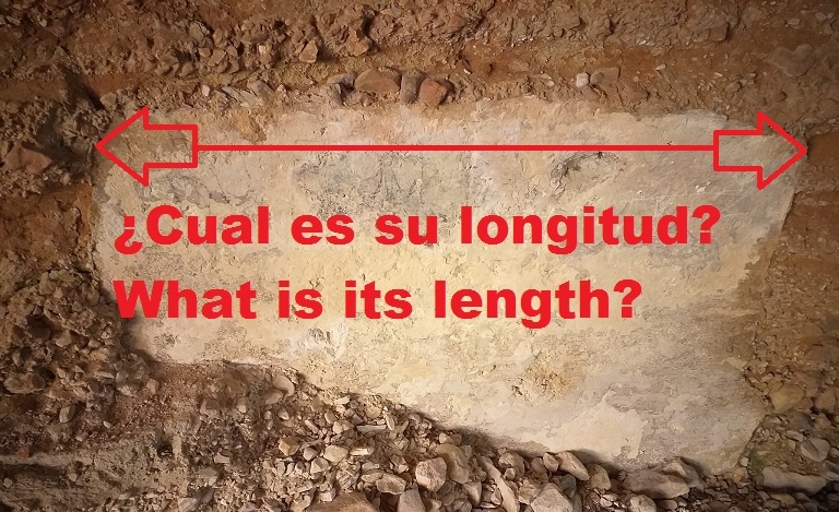
4.- Localiza la piedra y ¿Cual es su longitud?
5.- ¿Que significa SOPALMO?
6.-¿ Significado del término tubificación?
7.- ¿Como se formó este Túnel?
8.- Este tipo de EROSIÓN ¿En que zona de la Península tiene mas incidencia?
9- ¿Me podrías indicar cual es la provincia mas afectada por esta tipo de erosión?
10- Se agradecerá añadir al log una foto con tu GPS o presencia en el TUNEL DE SOPALMO,pero en cualquier caso, no es obligatorio.
BUENA SUERTE A LOS GEOCACHERS, ESPERO QUE LO DISFRUTEIS
------------------------------------------------------------
SOPALMO FONT TUNNEL
"SUFFOSION OR PIPING (TUBIFICACIÓN)"

This tunnel is located in the municipality of Ibi, more specifically in the Sopalmo area. It is located in the Gavarnera ravine, a few meters above the Sopalmo fountain, to the south-east of the urban area of Ibi.
It is a XX m tunnel. of route with section of A x B m. Its formation is due to the action of the water that has been eroding the gravels and less compact sands making its way through them.
This cavity has its history and, although its formation is due to the action of torrential water erosion, the origin of its birth could be due to the action of man, according to a local legend.
According to legend, the ravine was cut into a narrow and deep ravine, its waters leaping over the terraces and flooding them (Sopalmo Area). At the end of the 19th century, the owner of that area decided to build a small dam whose waters were channeled by opening a small tunnel channeled to the opposite part, more than 50 m away. where the ravine continued after having jumped on the surface flooding the terraces. That work went well while the waters fell calmly, but the strong avenues penetrated hard in the small tunnel until the area was abandoned, the waters began a process of erosion free of impediments, currently forming the great Sopalmo tunnel.
NOTE: Sopalmo: means irrigation or flood zone
=> HOW IS THE SOPALMO TUNNEL FORMED?
The Font de Sopalmo Tunnel is a consequence of surface runoff intercepted by desiccation cracks, animal galleries, or other openings, both in the slope as in a reservoir at the bottom of the valley. The water penetrates until it meets a layer of high porosity, or with an opening in the subsoil, or is blocked by an impermeable layer. The flow removes the particles from the ground, gradually enlarging the opening or conduit, like a tunnel and this erosion process gives the tunnel formation
This process is called SUFFOSION OR PIPING (TUBIFICACIÓN).
=> WHAT IS SUFFOSION OR "PIPING"?
The term suffosión comes from the Latin suffossio, which means to dig underneath. However, the term piping or in Spanish tubificacion (of pipe, pipe) is much more extended. We can define this concept as "the formation of natural conduits (pipes) in the soil or other deposits not consolidated by elevation or by processes of differential subsurface erosion".
It constitutes a set of current geomorphological processes that are very active in the soft sedimentary formations of the Southeast of the semi-arid Iberian Peninsula. Numerous factors and mechanisms can intervene in the development of conduits, tubes, tunnels and galleries; the wide diversity of shapes and variety of scales at which they are found seems to confirm this. Theories about the nature and genesis of soils with Sufosion, "Tubificación" or Piping, are many.
The type of erosion is an azonal process, since it is found in all climatic regimes; but it is in dry areas, preferably semi-arid, where it reaches a higher degree of development. This is due to three causes: the need for cracking due to desiccation that favors the start of the piping, the presence of sporadic torrential rains that feed the channels, tunnels and evacuate the material in favor of steep slopes, and the presence of a vegetation of steppe type, which favors the development of the process.
In summary, most of the studies suggest as factors that intervene in its initial development, of this type of erosion, the following:
1.- Semi-arid climatic conditions, specifically the amount and regime of rainfall. The sporadic and intense storm rains quickly feed the pipes and evacuate the material. The important hydraulic gradients that supply the storm rains are therefore necessary.
2.- Long periods without warm and rainy conditions that dry out and crack fine materials.
3. Soil texture and structure. The susceptibility to certain physical and chemical phenomena such as loss of cohesion, dispersion and perforation offered by soils with high content of clay and silt and, in particular, with a high proportion of swelling clays such as montmorillonite, illite and bentonite.
4.- Different erodibility and permeability of non-cohesive materials in the different layers of the soil and subsoil.
5.- Soils with a high content of soluble salts that offer a high base exchange capacity, particularly with sodium. The percolation of water and the correlative washing of sodium, leads to the dispersion of the material and its easy removal and transport by subsurface runoff.
6.- The degraded and regressive vegetation favors the previous processes.
7.- Certain human actions such as deforestation, overgrazing, terracing, abandonment of cultivated land in dry land ... they have unmistakable repercussions.
8.- Slopes, slope orientation, biological action of animals and roots, can favor the piping process in certain circumstances.
In general, in each bioclimatic and edaphogeomorphic context, the factors that initiate and develop piping may be different, some trigger it by themselves and others help to create these tubifications.
The action of man favors the formation of these ducts. Agricultural practices such as irrigation, deforestation, overgrazing, and terraces, trigger the process in many cases. In the same way, the action of animals that pierce the earth is another initiating phenomenon of suffusion, since the water uses the conduits of animal origin and develops the network of tunnels and subsurface galleries. Also the presence of roots, filled with unconsolidated materials can be used for the beginning and progression of the piping.
=>FSOPALMO TUNNEL DATA SHEET.
(sources: Diputación de Alicante and various textbooks)
=> ACTIVITY PROPOSED TO BE APPROVED THE EARTHCACHE:
To can logging this earth cache, you must visit the proposed TUNNEL the coordinates of this Cache and send to my email listed in my profile, the answers to the following questions. I will delete any log that does not fulfill that formality before:
1.- How long is the Tunnel?
2.- What width is the Tunnel? (by the place you accessed)
3.- How high is the Tunnel? (by the place you accessed)
4.- Locate the stone and what is its length?
5.- What does SOPALMO mean?
6.-Meaning of the term piping or "tubificación?
7.- How was this Tunnel formed?
8.- This type of EROSION In which area of the Peninsula does it have the most incidence?
9- Could you tell me which Spanish province is most affected by this type of erosion?
10- It will be appreciated to add to the log a photo with your GPS or presence in SOPALMO FONT TUNNEL, but in any case, it is not obligatory.
GOOD LUCK TO ALL GEOCACHERS, I HOPE YOU ENJOY