
The Tuia Mātauranga Pōkai Whenua GeoTour follows the footsteps of early explorers of Aotearoa New Zealand taking you to places where leaders of the past searched for food, resources and ways to adapt and survive in this new land.
Use the Pōkai Whenua GeoTour as your classroom to explore the stories of the past, in the present, to preserve what is unique in Aotearoa New Zealand for the future.
Collect the codewords to get the Geocoin puzzle piece.
To be able to complete this GeoTour and receive your special Geocoin collectable, remember to take note of the codeword for the cache. As this is an Earthcache, there is no codeword to find at the location - the codeword will be sent to you after you have fulfilled the logging requirements for this Earthcache. The codeword will need to be recorded in your passport which can be downloaded here.
|
Waro in the Waikato
Rotowaro, the last remaining coal field the Huntley area, has a long history of coal production. Looking out from the posted coordinates you will be able to see the opencast mine where the coal is extracted and then follow it to the processing plant at waypoint 2, where it is shipped for its many industrial and domestic uses.
Historically, Tainui Māori were the first to burn waro (coal) in New Zealand, for cooking, and early European settlers swiftly began prospecting. New Zealand currently has 18 producing coal mines - with the major coalfields located in the Waikato, the West Coast, Otago and Southland.
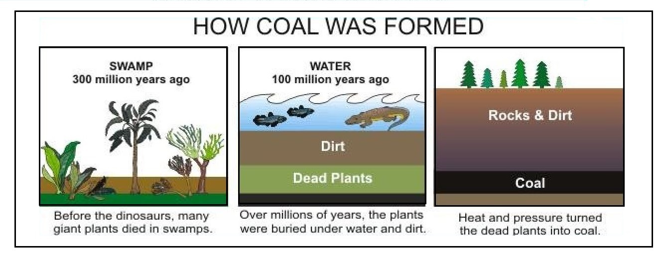
Coal is a combustible sedimentary rock formed from the remains of plant life and comprises the world's largest fossil energy resource. It is believed that during the Carboniferous period (280 to 345 million years ago) large amounts of plant life and other organic matter grew in the swampy areas and lagoons that covered much of the earth. As the plants and other life forms died, they drifted down to the bottom of the swamps, slowly decomposed, and formed peat—a soggy, sponge-like material. The peat became buried and compressed under the earth's surface. Over millions of years and through the forces of heat and pressure, the compressed peat became coal. The greater the heat and pressure, the harder the coal was that formed.
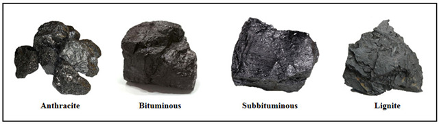
Coal is classified into four different categories. The differences in the types of coal are based on the amount of carbon in the coal and how it responds to increasing heat and pressure beneath the earth’s surface.
The Four Types of Coal:
- Anthracite - the highest rank of coal is a harder, glossy black coal and is the most valuable. It is used primarily for residential and commercial space heating and is blended with bituminous coals to make coke for the iron and steel industry. It is also used in chemical industries and can be found in plastics, synthetic rubber, insecticides, paint products and medicines.
- Bituminous – a dense sedimentary rock which is harder and blacker than lignite and subbituminous coal. It is used primarily as fuel in electric power generation and to make coke for the steel industry. Known as steam coal in the UK, it was historically used in steam locomotives and steam ships.
- Sub-bituminous - is the result of millions of years of continued pressure and high temperatures on lignite. It burns cleaner than other types of coal, producing less greenhouse gas emissions due to its low sulfur content. Subbituminous coal is used in electricity generation and also in industrial processes.
- Lignite –the lowest grade of coal which is often known as brown coal and is an intermediate stage between peat and coal. It is used almost exclusively as fuel for electric power generation but is the most harmful to health as it does not burn as cleanly and produces more air pollution.
Waikato Coalfields
While most of the world’s coal was formed 300–350 million years ago, New Zealand coals are much younger – they were made 30–70 million years ago. The Waikato coalfield was formed 30-35m years ago on old Eocene-Oligocene basement rocks. The coal seams that formed are from coastal swamp deposits and are confined to areas that were old valleys, chiefly around Huntly and Maramarua.

Originally a Māori settlement called Rāhui Pōkeka, Huntly was a military post during the Waikato war and a Pākehā settlement afterwards. The area has a very long history of coal mining, with both open cast and underground mines operating here. Many miners came from the South Island’s West Coast, the north of England and Scotland. Local Māori also entered the industry in large numbers. The first coal to be mined was half a ton at Taupiri in 1849, followed by 32 tons in 1850. The Kupakupa mine was started in 1864 and produced 11,000 tons by 1866. After the Pukemiro railway opened in 1915, mines opened at Pukemiro, Glen Afton, Rotowaro, Waikōkōwai and Renown. Open cast mining began west of Huntly during World War 2.
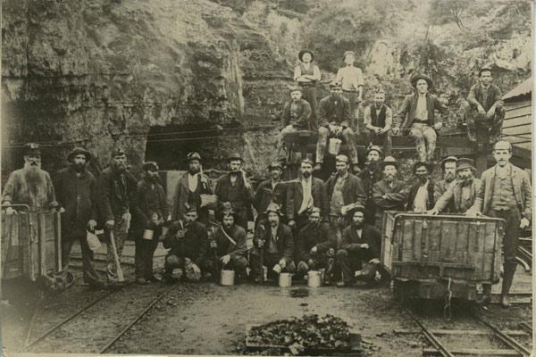 Mining is a dangerous industry and on 12 September 1914 at the Ralph Mine in Huntly, a naked light caused an explosion that killed 43 coal miners when a miner’s acetylene cap-lamp ignited methane gas given off by the coal. The ensuing fire made the rescue mission incredibly difficult and many of those who survived suffered terrible burns. A commission of inquiry found that the coal dust in the mine was highly flammable and ordered the immediate introduction of safety lamps.
The Huntly East Coalmine opened in 1978, produced a peak of 465,000 tonnes in 2004 and was digging about 450,000 tonnes a year until production was cut to 100,000 tonnes in September 2013. The mine entrance was in Huntly East, but by 2012 all mining was west of the Waikato river with the tunnels being 150 metres deep below the river. The thick sub-bituminous seams found here were 150 to 400 metres deep. This was the last Huntly underground mine and closed on 22 October 2015.
Rotowaro was once a small coal mining township approximately 10 km west of Huntly and was first mined in 1915. The current mine began production in 1958 and the town was entirely removed in the 1980s to make way for a large opencast mine. Rotowaro is now second largest opencast coal mine in New Zealand and produces sub-bituminous type coal. The majority of Rotowaro coal goes by overland conveyor to the Huntly Power Station and by rail to the Glenbrook steel mill. The remainder supplies North Island industrial and home heating markets.
To log this earthcache, you need to complete the following activities.
Email the cache owner with answers to the following questions.
1. At the posted waypoint (S37 36.134 E175 03.636) you can look across to Rotowaro opencast mine, describe the colours of the different layers on the sides of the mine and what do you think they are made of? Are you able to see any coal in this area?
2. What type of coal is produced at this mine and from what geological age do the basement rocks that lie under the coal come from? (Answers in text)
3. What is the name of the group of marine sediments that overlays this coal field on the western side? (Answer in text)
4. At the coal processing plant (S37 35.093 E175 05.275 - there is safe parking at the side of Waikokowai Road overlooking the plant), take a photo of you or your caching name with the buildings and coal piles in the background. Upload your photo with your cache log.
5. (Optional) Just down the road from the first waypoint (at S37 35.884 E175 03.766) where the railway track crosses the road there are two small coal seams can be seen along train track about 50 metres from the road. Can you find these coals seams?
Note: this track is used on the first Sunday of each month by the Glen Afton Heritage Railway, please check before venturing down the line.
References: