
The Tuia Mātauranga Pōkai Whenua GeoTour follows the footsteps of early explorers of Aotearoa New Zealand taking you to places where leaders of the past searched for food, resources and ways to adapt and survive in this new land.
Use the Pōkai Whenua GeoTour as your classroom to explore the stories of the past, in the present, to preserve what is unique in Aotearoa New Zealand for the future.
Collect the codewords to get the Geocoin puzzle piece.
To be able to complete this GeoTour and receive your special Geocoin collectable, remember to take a note of the codeword placed in the cache. This will need to be recorded in your passport which can be downloaded here.
|
The Power of Flowing Water
The Waikato, the longest river in New Zealand, runs for 425 kms from Lake Taupō to just south of Auckland where it flows out into the Tasman Sea at Port Waikato. Its name translates from the Māori language as ‘flowing water’ and in the past this river has been an important transport route for both Māori and early European settlers to reach inland communities which sprang up along its banks.
The Waikato's first hydroelectric power station was the Horahora Power Station. It was built between 1910 and 1913 to supply electricity for the Martha Gold Mine at Waihi and operated until it was submerged by Lake Karapiro in 1947.
The river now has a series of eight dams and nine hydroelectric power stations that generate electricity for the national grid. These were constructed between 1929 and 1971 to meet the growing demand for electricity. Approximately 4000 gigawatt hours (GWh) of electricity is generated annually by the scheme, which is around 10% of New Zealand's total electrical generating capacity.
The nine hydroelectric stations which form the Waikato power scheme are:
| Name |
Capacity (MW) |
Year Comissioned |
| Arapuni |
196 |
1929 |
| Aratiatia |
78 |
1964 |
| Ātiamuri |
84 |
1962 |
| Karapiro |
90 |
1948 |
| Maraetai I |
252 |
1954 |
| Maraetai II |
108 |
1971 |
| Ohakuri |
112 |
1962 |
| Waipapa |
51 |
1961 |
| Whakamaru |
100 |
1956 |
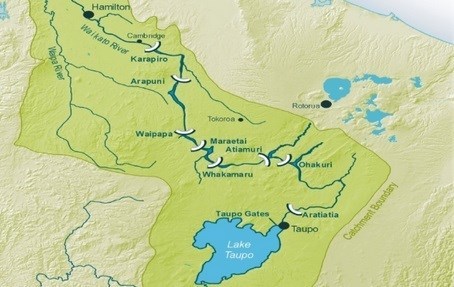 The power scheme begins at Lake Taupō, which has control gates to regulate the flow of water into the river. Once released through the gates it takes over 18 hours for the water to flow to the last power station at Karapiro on its journey downstream.
Arapuni Power Station is the oldest remaining hydroelectric power station and was the first high dam built on the Waikato river. It pioneered the development of the Waikato Valley Hydroelectric Power Programme and was the first government built station.
Surveying of the site began in 1916, but in 1920 work was halted due to lack of government funds. In 1923, worldwide tenders were called for the building of Arapuni and access to the site from Putaruru commenced. A contract was placed with the British firm of Armstrong Whitworth in September 1924 and construction of Arapuni finally began but heavy rain and the resulting floods slowed early progress. The diversion tunnel which moved the river away from the construction site was completed in July 1926, allowing the dam to start construction soon after. Good progress was made building the dam, but at the powerhouse site there was disagreement between Armstrong Whitworth and the Public Works Department over the foundations which resulted in the Public Works Department taking over the project in December 1927. The dam built across the Arapuni Gorge is 64m high and diverts the water along a 1.2km channel to the powerhouse at the base of the gorge.
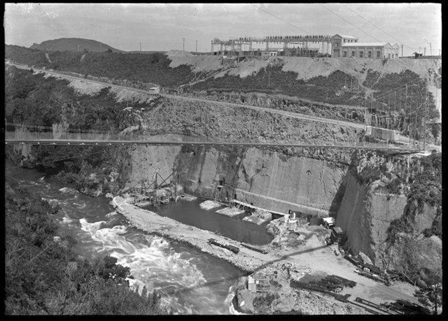
The station was commissioned in mid-1929 with three turbines, but shortly after it was closed for two years while a water seepage problem was investigated and fixed. It was recommissioned in May 1932 with the addition of a fourth turbine and the water intake channel having been lined to stop the water seepage.
In 1934 the powerhouse was doubled to its current size to allow four more turbines to be added. Turbines 5 and 6 were commissioned four years later in 1938 with the last two turbines added in 1946 to meet the increasing demand for electricity following World War II. This brought the power station to a total capacity of 162 megawatts (MW), by far the largest in New Zealand at the time.
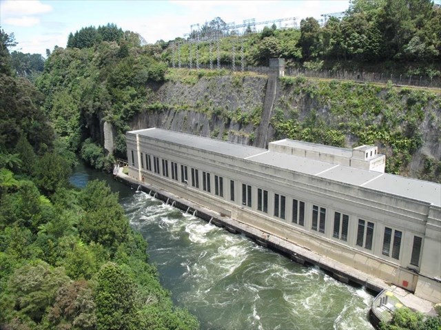
Since 1990 the power station has had a number of upgrades; from relining the intake channel, fixing historic water seepage problems and upgrading the turbines and power station equipment to make them more efficient. This has now increased the generating capacity to 196 MW.
The powerhouse and dam at Arapuni are under protection of the Historic Places Trust and are recognized as being a nationally significant site.
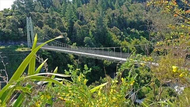
The Arapuni Suspension Bridge was built as part of the construction of the Arapuni Dam and Power Station to allow workers from the village of Arapuni to access the power station construction site. It is 152 metres long and was designed and prefabricated in England then shipped to New Zealand where it was constructed between May 1925 and May 1926. It is also under protection of the Historic Places Trust and is a popular tourist site allowing visitors to get a great view of the river and the power station.
To find this cache you need to answer the following questions:
At waypoint 1 (‘Arapuni World War II’ information sign - S 38° 04.236 E 175° 38.732) find the following for the South coordinates:
AB = In the quote from Jim Howland (2nd paragraph of 'Preparing for invasion''), what number word is 'attacked'? (count from beginning of the second paragraph)
C = A ___ generator was in action on 28 August 1942 (number of letters in the word)?
At waypoint 2 (Arapuni turbine and plaque - S 38° 04.248 E 175° 38.757) find the following for the East coordinates:
D = What is the number of the month that the plaque was unveiled?
EF = Count the number of blades on the turbine and multiple the number by 2.
The cache can be found at: S 38° 04.ABC E 175° 38.DEF

The lock code is: 5938
PLEASE NOTE: To retrieve the PWGT code for this cache you will need to bring a large bottle of water with you. Pour water in slowly in the top to avoid air getting trapped. You only need to block the one hole at the bottom of the cache for it to work.
If you have trouble retrieving the container, then please send us a message with the number of power poles painted inside the cache and we will send the code to you.
Wheel does not need to turn to retrieve codeword.
Thanks to Mercury Energy for permission to place this cache.
This cache is made from an old metal power box that has been under our house for years, a piece of old board, some piping, odd bits and pieces, an old lunch container, part of a broken tea strainer, paint test pots we already had and a little bit of experimentation.
References: