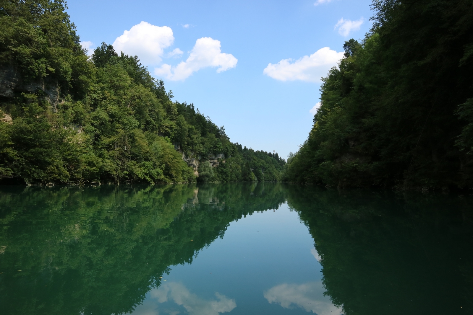
Pod Kranjem je v dolžini 20 kilometrov do Medvod reka Sava vrezovala strugo v lastne pleistocenske naplavine. Od Kranja, preko Drulovke do Trboj je področje vršaja reke Kokre. To je preperel svet, prekrit s tanjšo plastjo ilovice in peska; prodno nasutje je trden konglomerat. Skupna debelina nanosa presega 100 metrov. Na njem opažamo več akumulacijskih in erozijskih faz. V zadnji erozijski fazi se je Sava zarezala v sprijete nanose od Drulovke do Jame v dolžini 3 kilometre v ozko, v prvem delu izredno slikovito sotesko z navpičnimi, ponekod celo previsnimi stenami (globine od 15 do 20 metrov). V sami strugi in ob bregu so veliki konglomeratni balvani, odtrgani od sten. V steni so luknje in spodmoli. Pod Trbojami je v akumulacijskem jezeru potopljen prevotljen konglomeratni balvan, znan pod imenom Votlenik. V tem delu je bogata ornitofavna. Ob dokumentiranju pred zajezitvijo Save (leta 1980) so popisali 56 rastlinskih in 300 živalskih vrst. Posebej zanimivo je dejstvo, da je v soteski Zarice celo rastišče nekaterih alpskih vrst (npr. planike – Leontopodium alpinum).
Konglomerat je debelozrnata klastična sedimentna kamnina, ki nastane s sprijetjem proda. Sestavljajo jo zaobljeni prodniki, kar je izrazit ločitveni znak od breče, ki jo sestavljajo oglati kamenčki. Ime konglomerata izvira iz latinske besede conglomerare in pomeni nakopičiti.
Odlomke, ki nastanejo pri preperevanju in eroziji starejše kamnine, na poti do mesta odložitve v močnem in hitrem rečnem toku, kotaljenje po dnu struge in trkanje med seboj, zmanjša in obrusi. Nastanejo prodniki. Širše kot je zaledje reke, od koder pritoki prinašajo kamninski material, bolj pestra je njegova geološka zgradba. Tako se med seboj pomešajo prodniki magmatskih, metamorfnih in sedimentnih kamnin. Največje količine proda reke odložijo v:
-
aluvialnih vršajih, to je v pahljačastih prehodih iz ozkih dolin v širše ravne doline,
-
na aluvialnih ali poplavnih ravninah, to so nanosi, ki jih reke periodično odlagajo ob poplavah in
-
v zgornjih delih ter koritih rečnih delt na izlivih rek v morje.

Prod se začne zgoščevati in komprimirati ter z vezivom sprijemati. Vezivo je lahko mineralni cement (najpogosteje kremenov ali kalcitni), ki se izloča iz vodne raztopine, ali drobnozrnata osnova (peščena, glinena ali lapornata), ali pa oboje. Proces se imenuje diageneza ali vezanje (cementiranje), in je lahko fizikalni, fizikalno-kemični in biokemični. Različni tipi konglomerata vsebujejo različno velike prodnike in različno količino veziva (matriksa), ki jih drži skupaj. Če raztopimo matriks, kamnina razpade.
---------------------------------------------------------------------------------------------------------
Za uspešno najdbo zaklada odgovorite na spodnja vprašanja. Odgovore obvezno pošljite s sporočilom preko geocaching strani in ne po elektronski pošti. Po poslanih odgovorih lahko najdbo nemudoma logirate, če bo kaj narobe, vas bomo kontaktirali. Naloge za vpis:
-
Na koordinatah zaklada vidite na drugi strani reke konglomeratno steno. Ocenite njeno višino.
-
Približajte se steni pred vami. Na tleh so njeni odkruški. Koliko jih je? Dobro si jih oglejte in odgovorite z vašimi besedami, zakaj je tukaj konglomerat in ne breča.
-
Pojasnite z vašimi besedami, zakaj je stena pred vami poraščena.
-
Na koordinatah zaklada naredite fotografijo v smeri zahoda in jo prilepite k svojemu logu.
English:
Below Kranj, in the length of 20 kilometers to Medvode, the Sava River carved its bed into its own pleistocene alluvium. From Kranj through Drulovka to Trboje is the area of the top of the river Kokra. It is weathered soil, covered with a thinner layer of clay and sand; gravel backfill is a solid conglomerate. The total thickness of the coating exceeds 100 meters. Several accumulation and erosion phases are observed on it. In the last erosion phase, the Sava cut into the adjacent deposits from Drulovka to Jama in the length of 3 kilometers into a narrow, in the first part extremely picturesque gorge with vertical, in some places even overhanging walls (depth from 15 to 20 meters). In the riverbed itself and along the bank are large conglomerate boulders torn from the walls. There are holes in the wall and sink. Below Trboje, a hollowed-out conglomerate boulder, known as Votlenik, is submerged in an accumulation lake. There is a rich ornithofauna in this part. When documenting before the Sava dam (in 1980), 56 plant and 300 animal species were recorded. Of particular interest is the fact that in the gorge of Zarice there is even a habitat of some alpine species (plantains - Leontopodium alpinum).
A conglomerate is a thick-grained clastic sedimentary rock formed by the adhesion of gravel. It consists of rounded pebbles, which is a distinct sign of separation from the breccia, which consists of angular pebbles. The name conglomerate comes from the Latin word conglomerare and means to accumulate.
Fragments formed during weathering and erosion of older rock, on the way to the site of deposition in a strong and rapid river flow, rolling along the bottom of the riverbed and colliding with each other, reduce and grind. Pebbles are formed. The wider the hinterland of the river, from where the tributaries bring the rock material, the more varied its geological structure. Thus, pebbles of igneous, metamorphic and sedimentary rocks are mixed with each other. The largest quantities of river gravel are deposited in:
- alluvial peaks, in fan-like transitions from narrow valleys to wider flat valleys,
- on alluvial or flood plains, sediments that are periodically deposited by rivers during floods and
- in the upper parts and riverbeds at the mouths of rivers into the sea.
The gravel begins to thicken and compress and adhere to the binder. The binder can be mineral cement (most commonly quartz or calcite), which is extracted from an aqueous solution, or a fine-grained base (sandy, clay or marl), or both. The process is called diagenesis or binding (cementation), and can be physical, physicochemical, and biochemical. Different types of conglomerate contain different sizes of pebbles and different amounts of binder (matrix) that holds them together. If we dissolve the matrix, the rock disintegrates.
---------------------------------------------------------------------------------------------------------
To successfully find the cache, answer the questions below. Be sure to send the answers by message via the geocaching site and not by email. After sending the answers, you can log the find immediately, if something isn't right, we will contact you. Enrollment tasks:
- At the cache coordinates you see a conglomerate wall on the other side of the river. Estimate its height.
- Approach the wall in front of you. Fragments of the wall are in front of you. How many are there? Take a good look at them and answer in your own words, why there is a conglomerate here and not a breccia.
- Explain in your own words why the wall in front of you is overgrown.
- At the cache coordinates, take a photo in a westerly direction and paste it to your logo.