
The Tuia Mātauranga Pōkai Whenua GeoTour follows the footsteps of early explorers of Aotearoa New Zealand taking you to places where leaders of the past searched for food, resources and ways to adapt and survive in this new land.
Use the Pōkai Whenua GeoTour as your classroom to explore the stories of the past, in the present, to preserve what is unique in Aotearoa New Zealand for the future.
Collect the codewords to get the Geocoin puzzle pieces.
To be able to complete this GeoTour and receive your special Geocoin collectable, remember to take a note of the codeword placed in the cache. This will need to be recorded in your passport which can be downloaded here .
63 of the 150 Pōkai Whenua GeoTour caches will contain a randomly placed special FTF token (a replica of the Tuia Mātauranga GeoTour commemorative coin). This is yours to keep! If you find more than one, you might consider leaving it for the next person who finds the cache.
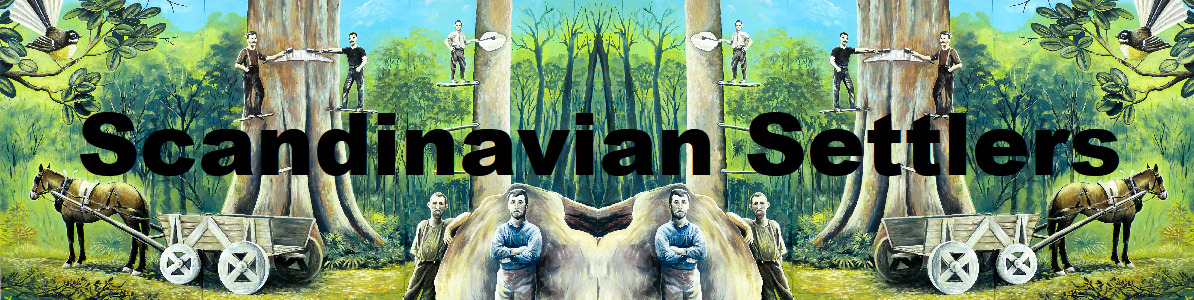
Dannevirke was founded by Scandinavian immigrants, who were brought to New Zealand by the government in 1872 to fell the forest that covered much of southern Hawke’s Bay and then to farm the cleared land. Ten acres (4 hectares) was set aside for the town, and each settler family got a 40-acre (16-hectare) block.
Why were Scandinavians chosen for this task?
Bishop D. G. Monrad, a former prime minister of Denmark, had settled in the Manawatū in 1866 accompanied by his family and five young Danish men. Together they successfully cleared the bush at Karere. At the time Palmerston (North) had been surveyed, but a swathe of forest stood between it and the port of Foxton. The energetic Manawatū Danes helped convince Colonial Treasurer Julius Vogel that Scandinavians were eminently suitable for the job of clearing the forest. In 1871 18 families recruited from Norway, Sweden and Denmark settled on 40-acre sections between Palmerston and Foxton. They opened a road and tramway through the bush giving settlers access to Palmerston.
Vogel pursued a similar strategy to clear the forest on the other side of the Ruahine Range. This forest, known to Māori as Tapere-nui-a-Whātonga, stretched 70 miles from the Wairarapa to Hawke’s Bay. Vogel planned to establish Scandinavian settlements along surveyed road and rail lines though the bush.
So in 1871 the New Zealand government sent Swedish settler Bror Erik Friberg to recruit in Norway and Sweden. Settlers were offered subsidised passage and 40 acres of land at £1 per acre, all of which could be paid off by working on road and rail construction. In May 1872 the ship Høvding left Christiania (Oslo) for Napier with 365 Norwegians and 11 Danes. Meanwhile in London, the Ballarat (with 71 Danes aboard) also set sail for Napier.
By 1872 the government-named Scandinavian towns of Norsewood and Dannevirke were surveyed. Dannevirke’s plans show evocative street names such as Gertrude, Dagmar, Christian and Hamlet. But these roads existed on paper only and the young immigrant families arrived to an expanse of dense forest.
As farms were drawn by ballot, nationalities were mixed throughout the region, although there were concentrations of Norwegians in Norsewood and Danes in Dannevirke. Families often shared crude punga and tōtara bark houses while ‘slabs-hus’ (slab huts) were built. Men laboured on roads and railways, often living away from home to pay debts. Women and children remained in rough forest homes growing cabbages, potatoes and carrots among the tree stumps. Fever claimed seven lives by January 1873.
Bushfires helped clear the felled forest but many houses, barns and fences also went up in smoke. In 1888 a massive bushfire razed Norsewood and threatened to do the same to Ormondville until a timely thunderstorm extinguished it. During the 1880s the railway slowly progressed through the bush. Sawmilling began, and tree by tree the land was cleared to become productive farmland.
During the early years of assisted migration (1871–76) there were 3,327 arrivals. In 1878 Scandinavians comprised just over 1% of the New Zealand population – the highest proportion they were ever to reach.
Because Norwegian, Danish and Swedish are similar languages, barriers were minimal among the ‘Skandies’, as they were nicknamed. In the early years four periodicals appeared in Scandinavian languages, but they were short-lived. Most settlers were keen to become naturalised as British citizens. With intermarriage and internal migration, languages died with the first and second generations.
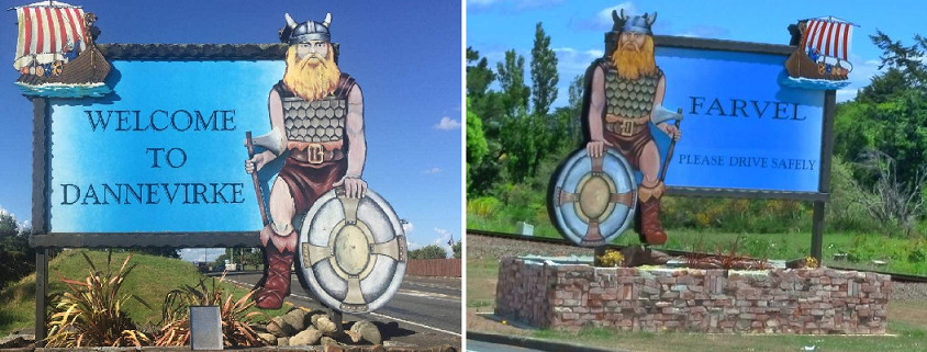
Danish was last widely spoken in Dannevirke in the 1900s and Norwegian in Norsewood in the 1920s. Today the main vestiges of the language in these original settlements are surnames, street names and gravestone inscriptions. Dannevirke’s Scandinavian heritage can be seen throughout the town in the (controversial) Viking warrior signs, which also feature on the Welcome to Dannevirke signs. The back of each sign says ‘Farvel’ (Farewell in Danish).
Before European settlers arrived in the 1870s, the line of descent for Maori in the area was from the Kurahaupō waka. The tribe of the area is Rangitāne, with geographic distinction to Te Rangiwhakaewa in the immediate Dannevirke region. The first known 'Aotea' meeting house was established approximately 15 generations ago (from 2010) followed by the building of a marae at Makirikiri near Dannevirke at about the same time as the first Nordic settlers.
The cache is NOT at the posted coordinates. Instead they will take you to the Dannevirke Settler’s Cemetery where you will find a signboard. Use the information posted here to obtain the coordinates for the Final. You will also need to locate a commemorative plaque under the tree in the centre of the cemetery (directly up the path from the gate).
The cache is at S40 12.ABC E176 06.DEF where:
A = The last digit of the year on the plaque
B = The last digit of the age of Jorgen Gronnebeck
C = The last digit of the age of Bodil Berntsen
D = The last digit of the age of Herman Wiesner
E = The second to last digit of the year on the plaque
F = The last digit of the age of Charles Edkins (F80)
Checksum A+B+C+D+E+F = 28
The hide is located not far away, and is in keeping with the occupation of the first settlers. Lift the ‘lid’ only, and please replace securely.
In keeping with the conservation theme of this Geotour, all our caches and logbooks are made of recycled materials, or items we had on hand already.