
The Tuia Mātauranga Pōkai Whenua GeoTour follows the footsteps of early explorers of Aotearoa New Zealand taking you to places where leaders of the past searched for food, resources and ways to adapt and survive in this new land.
Use the Pōkai Whenua GeoTour as your classroom to explore the stories of the past, in the present, to preserve what is unique in Aotearoa New Zealand for the future.
Collect the codewords to get the Geocoin puzzle pieces.
To be able to complete this GeoTour and receive your special Geocoin collectable, remember to take a note of the codeword placed in the cache. This will need to be recorded in your passport which can be downloaded here .
63 of the 150 Pōkai Whenua GeoTour caches will contain a randomly placed special FTF token (a replica of the Tuia Mātauranga GeoTour commemorative coin). This is yours to keep! If you find more than one, you might consider leaving it for the next person who finds the cache.
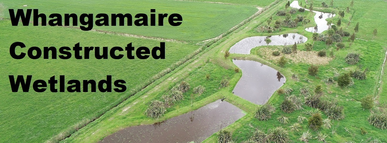
A "science experiment" on neighbouring Waikato dairy farms is becoming a showcase for wetland system innovation. The experiment involves two unique wetland projects which are beginning their life-long mission to decrease agriculturally-derived sediment and nutrients entering the Whangamaire Stream in North Waikato. Whangamaire is a tributary of the Mangawara Stream which feeds into Waikato River near Taupiri, and is culturally significant to iwi. The Whangamaire stream bank was once the site of the recently rediscovered Te Uapat Pā. This site was the home of the tūpuna (ancestor) Mahuta after whom the Ngāti Mahuta tribe of the Waikato take their name.
It has taken two years to complete the Whangamaire Constructed Wetland project and it could take a few more years before it starts to generate results. But the farmers, land owners and scientists backing the project believe it'll stand as a blueprint for others to follow, to reduce the environmental impact of farming and improve water quality.
A NIWA review of research into seepage wetlands in New Zealand over the past two decades showed wetlands are remarkably effective at stripping nitrate, a problematic form of nitrogen, through a process known as denitrification. The review offers robust evidence that seepage wetlands benefit water quality, and therefore these wetlands should be prioritised for stock exclusion and protected against further drainage. Over 90 per cent of wetlands have been drained in the past 200 years, with many North Island regions most affected. Continued drainage is an ongoing threat.
In NIWA's review of 14 seepage wetland studies across New Zealand where nitrogen concentrations were monitored entering and leaving the wetland, the same consistent finding emerged of remarkably high nitrate removal rates (75-98 per cent). Seepage wetlands have benefits other than water quality too. By capturing runoff, wetlands can lessen the intensity of flooding, reducing erosion and degradation of downstream and estuary habitats.
Bigger seepage wetlands will deliver greater denitrification benefits, with an optimum wetland size at about 5 per cent of their catchment area (the land drained). However, even small areas of wetland (across 1-5 per cent of the catchment) can markedly reduce a farm's overall nitrogen footprint.
The process of restoring seepage wetlands is relatively straight-forward because of where they naturally occur – in areas with organic-rich, low-oxygen and saturated soils. This is often marginal land for farming. The first step is to fence off these wetlands from stock. Then plant with low-growing, lower bank natives, or alternatively maintain rank grass cover which wetland plants like reeds and rushes can naturally recolonise.
At the Whangamaire wetlands, Patience Walker and Grant Stokes own neighbouring farms near Taupiri. Their farms are at the centre of the project led by Manaaki Whenua - Landcare Research and project manager Suzanne Lambie.
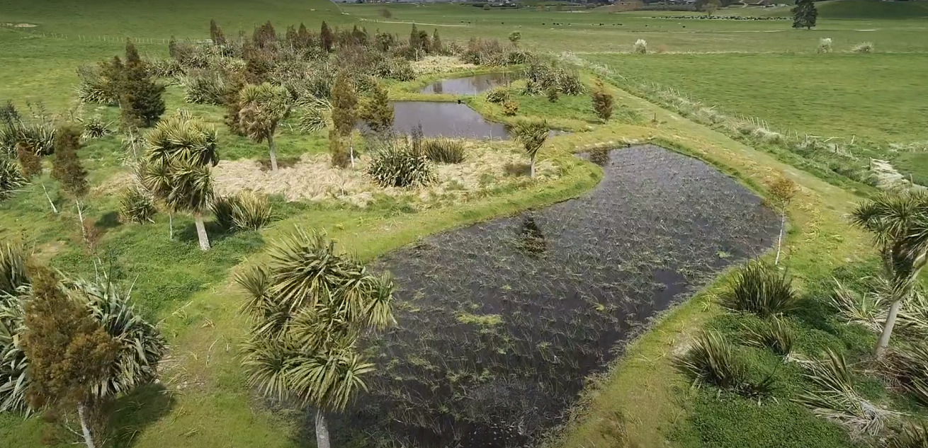
On the Walker farm, a 2600sqm site already retired from farming was used for the uniquely constructed wetland system. Patience Walker's sons planted this area in native trees about 20 years ago and so the wetland has been built around the existing environment. The wetland features four small ponds which are sequentially connected. In each pond, a different species of native plant has been established.
The first has raupō which absorbs large amounts of nitrogen out of the water and dies down in winter.
The second pond has jointed twig rush, it removes nitrogen at lower levels but retains foliage all year round.
The third has purua grass, a species with relatively high nitrogen demand, and dies down in winter.
The fourth pond has kuawa, just like twig rush, lower nitrogen demand and retains foliage all year.
Lambie said the idea is to monitor how well each plant species performs in terms of removing nutrients over time.
An inlet at the first pond diverts water from a drain, which carries agricultural run-off from the Walker and neighbouring farms. The run-off progresses through the four ponds and at each step, plants take up nitrogen and phosphorus from the water to grow. Micro-organisms live in the water around the plants and they also remove nitrogen. The run-off water slows as it enters each pond. Particles and phosphorus fall out to form sediment, which can be removed and used as fertiliser later. An outlet at the fourth pond delivers the water, with reduced levels of nitrogen, back into the drain and it eventually makes its way into the Whangamaire Stream.
About a kilometre away on the Stokes property, the project there comprises one large wetland pond, about 1800sqm, with four native plant species embedded together. Lambie said she'll be able to monitor the effect of "monoculture versus diversity" between the two wetland systems. "The pond at Grant's property is bigger and all of the plant species are together but we're hoping both wetland systems will do the same job. They are both catching all of their neighbours run-off before the water heads into the Whangamaire Stream."
Niwa had also conducted some initial insect trapping around the four-pond system to "see who's living in there now". Longer term, there might be a proposal to look at fish ladders, to enable aquatic life to migrate from one wetland pond system to another, from farm to farm.
A road leads down to the Walker farm wetland (at the posted coordinates) and a car park was made especially to allow invited groups to see the project. (Please do not visit uninvited – the cache is not here). It's hoped it will inspire other land owners to think about retiring wet areas of land not suitable for farming.
The information you need to calculate the coordinates can be found in the text on the cache page and in this short video.
From the above text:
What percentage of NZ wetlands have been drained in the past 200 years? = AB%
What percentage of a catchment area is the optimum size for a wetland? = C%
How big is the area retired from farming on the Walker farm? = D,E00 sq m
Which pond has been planted with the rush species kuawa? = F
From the video:
How much did each landowner donate to help with the project? = $G,000
How many plants were planted in the two wetland areas? = HJ,000
How many hours have volunteers put into the project? = KL0
Find the cache at S37 3 (J-H) . E F G E175 1 L . B (KxL) C
The final is near a wetland area that could benefit from implementing a similar scheme. You are looking for something you might expect to find in a wetland.