ILLER CREEK CONSERVATION AREA
Welcome to Iller Creek Conservation Area, Rocks of Sharon, Big Rock, Tower Mountain or Krell Mountain, whatever you choose to call it. This area has many names, but it all means just one thing; lots of fun!
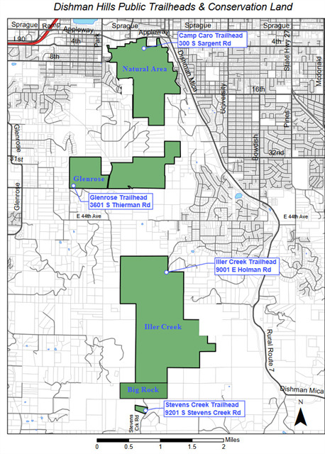
This area is part of the Dishman Hills Conservation Area. The Dishman Hills is comprised of three units of land that are open to the public: the Dishman Hills Natural Area, Glenrose, and Iller Creek. There are also about 500 acres of the Dishman Hills, including the newly-acquired Wilson Conservation Area, that are not yet open to the public, as there is no legal access, parking, or trail systems yet.
The Iller Creek Unit of Dishman Hills Conservation Area consists of 966 acres of County-owned, preserved open space. Together with Dishman Hills Conservancy-owned property, 1,233 acres of scenic, high quality habitat is available for hiking, biking, rock climbing and snowshoeing. While the DHCA currently consists of two separate areas in the Glenrose and Iller Creek areas, a long-term vision is emerging that could eventually connect the two areas and Dishman Hills Natural Area to create a large wilderness-like area within 5 miles of downtown Spokane.
Iller Creek boasts a wonderful five-mile loop consisting of lush shaded forest and a ridge line ramble with outstanding views of the Washington Palouse to the South and the Selkirks to the North and East. In the middle of the hike one reaches the Big Rocks (Rocks of Sharon), one of the best rock climbing destinations in the area. Here you will find expansive views of the surrounding scenery and towering rock formations. You can see the Palouse stretched out at your feet, and even Steptoe Butte in the distance. Keep your eyes open and you may see deer, moose, elk, bears, coyotes, many species of birds and other forms of wildlife, as well as many varieties of wildflowers.
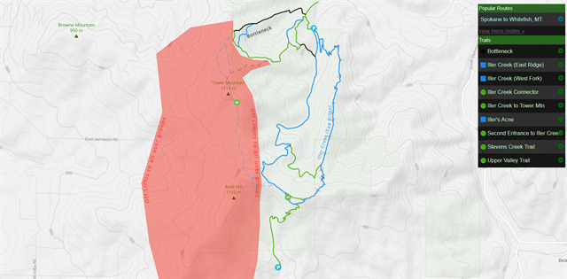
There are 2 trailheads to this area: Iller Creek Trailhead to the north and Stevens Creek Trailhead to the south. When I first discovered this place, the trail system encompassed the very top ridgeline, where all the towers are. Since then it has been closed, due to private property. They're trying to get access to the trails again, but I wouldn't hold my breath. So sad! Do not attempt to access the old ridgeline trails.
CACHE is just off the main trail, but down the steep bank a bit. Watch your footing! Snow makes it worse. The terrain rating is because of the steep bank down to the container.
INFO:
There is no parking fee or entrance fee for this hiking area.
There is a porta potty at each trailhead.
As usual, please do not leave any valuables in your vehicle!
Bears have been spotted in the area. Please use caution, and keep your dogs under control. It's always nice to carry bear spray when out hiking.
Iller Creek Conservation Area, updated with trail closures:
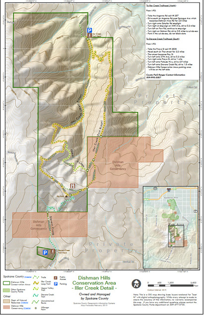
Iller Creek Conservation Area map
All 3 areas of Dishman Hills
MY OTHER HIKING CACHES:
Priest Lake
Priest Lake2
English Point
Hawk Hill
Farragut State Park
Antoine Peak
Liberty Lake
Missile Site
Pend Oreille County Park
Dishman Hills
McKenzie
Palisades Park
Round Lake
Slavin
Wolf Trails
Rathdrum Mountain