I love it when someone tells me to take a hike! That's all I need to hear to get me going out into the great outdoors!
When I go to a new hiking area, it's always SO helpful to me when I know parking & trailhead info, and what trails are available, and how far the hikes are for all the trails. I got to thinking that other people would be grateful for this valuable information also, so I've decided to create some caches that will help others, like it does me. I am going to publish a series of caches with all the information that I can find to help hikers to make informative decisions. I hope these caches help you!
This is a very beautiful hiking area. It's basically flat, with just a few gradual hills. There are miles of trails here, and it is open year-round. You will see hikers, bikers and horseback riders, and in the winter you will see snowshoers and cross-country skiers. Motorized vehicles are not allowed. I am trying to learn my way around these trails, and am still just learning. As I figure them out, I will post more information and coordinates for all the trails.
Parking is free here, and it is a very big parking lot. There is NO BATHROOM AT ALL here, so be aware. Also, bring plenty of bug spray! I don't know why the mosquitoes are so bad here, but sometimes they are.
PARKING LOT is at: N 47* 58.243 W 117* 24.265
Here is the info on the trail to THIS CACHE:
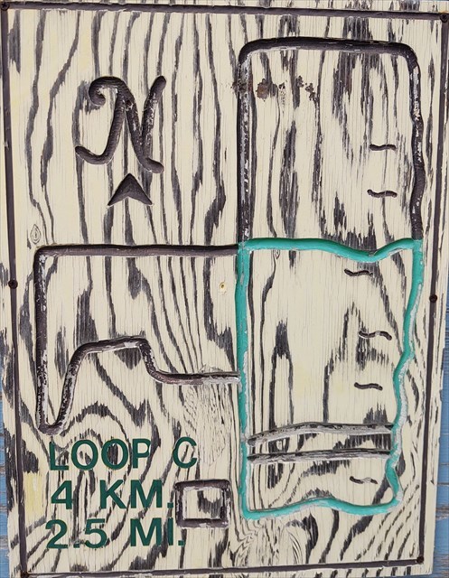
There are nice roads/trails that take you right to the cache, as well as right by other geocaches. Go straight to a main trail junction at: N 47* 58.885 W 117* 24.228, then turn right. This takes you straight to the cache which is at another main trail junction at: N 47° 58.906 W 117° 23.604. OR Go right from parking lot. The road takes a 90-degree turn. This will take you straight to the cache. This square route is "Route C" and is 2.5 miles around. It is the green loop. There are at least 12 other geocaches along the way. Some may be slightly off trail.
GREEN LOOP "C" - 2.5 miles:
Start at N 47° 58.256' W 117° 24.212'. Walk north approx .75 mile.
Turn right at junction at N 47° 58.885' W 117° 24.228'. Walk east approx .5 mile.
Turn right at junction at N 47° 58.887' W 117° 23.588' and walk south approx .75 mile.
Turn right at corner at N 47° 58.237' W 117° 23.575' and walk west approx .5 mile.
Feel free to walk this route in reverse!
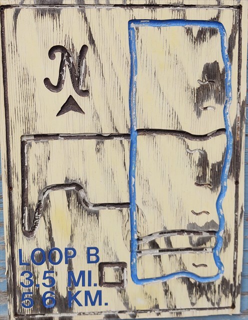
BLUE LOOP "B" - 3.5 miles:
Start at N 47° 58.256' W 117° 24.212' and walk north approx 1.25 miles.
Turn right at corner at N 47° 59.304' W 117° 24.224' and walk east approx .5 mile.
Turn right at corner at N 47° 59.313' W 117° 23.577' and walk south approx 1.25 mile.
Turn right at corner at N 47° 58.237' W 117° 23.575' and walk west approx .5 mile back to the start.
Feel free to walk this route in reverse!
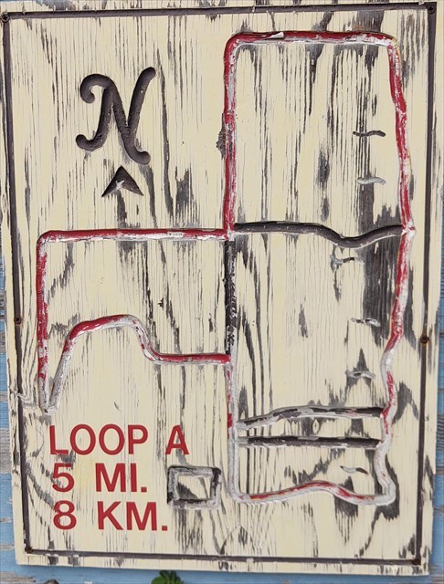
RED LOOP "A" - 5 miles:
Start at N 47° 58.256' W 117° 24.212'. Walk north approx .40 mile.
Turn left at N 47° 58.594' W 117° 24.236'W and walk west, following trail. The trail will meander north, west and south before hitting the perimeter road at N 47° 58.468' W 117° 24.883' or just north of that, if you take the little cutoff. When you hit the perimeter road, you will head straight north again, for approx .5 mile. Turn right at N 47° 58.882' W 117° 24.879' and walk east approx .5 mile.
Turn left at N 47° 58.885' W 117° 24.228' and walk north approx .5 mile.
Turn right at corner at N 47° 59.304' W 117° 24.224' and walk east approx .5 mile.
Turn right at corner at N 47° 59.313' W 117° 23.577' and walk south approx 1.25 mile.
Turn right at corner at N 47° 58.237' W 117° 23.575' and walk west approx .5 mile back to the start.
Feel free to walk this route in reverse!
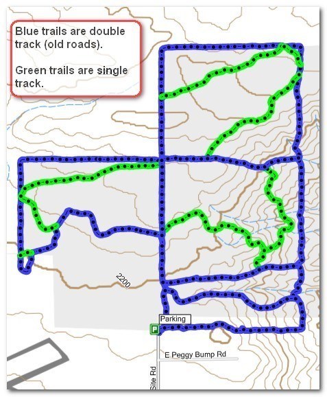
OTHER TRAILS (shown in picture below):
FIRST crossroad (in blue) after heading north from starting point:
WEST trailhead is: N 47° 58.386' W 117° 24.203'
EAST trailhead is: N 47° 58.347' W 117° 23.594'
SECOND crossroad (in blue, aka Enoch Lane) after heading north from starting point:
WEST: N 47° 58.418' W 117° 24.223'
EAST: N 47° 58.483' W 117° 23.591'
THIRD crossroad (in blue) after heading north from starting point (is the north perimeter of the green loop):
WEST: N 47° 58.885' W 117° 24.228'
EAST: N 47° 58.887' W 117° 23.588'
On the map below are GREEN trails. I will give you coordinates to them, but for now some may be approximate:
In the middle blue square of the map below are your first green trails. Here are the coordinates of the one in the lower left quadrant of this blue square. This trail takes off from the main straight road, basically at a big trail junction, and loops around till it hits E Enoch Lane, which is a nice road/trail that takes you back to the main straight road again. It's basically a loop, and from the parking lot, around, and back to the parking lot I walked 1.85 miles.:
WEST TRAILHEAD (green dotted line) is at: N 47* 58.607 W 117* 24.222
TRAIL HITS E ENOCH LANE AT: N 47* 58.470 W 117* 23.765
E ENOCH LANE HITS THE MAIN ROAD AGAIN AT: N 47* 58.418 W 117* 24.223
Here are the coordinates of the trail in the upper right quadrant of the middle blue square:
TOP of trail leaves road at: N 47° 58.853' W 117° 23.758'
This trail hits the other green trail at: N 47° 58.543' W 117° 23.751'
The combined trail hits Enoch Lane at: N 47* 58.470 W 117* 23.765
The top blue square has a couple trails that together, on the map, look like a bobby pin. These are coordinates (some more approximate than others) from west, clockwise. Here they are:
WEST trailhead: N 47° 59.124' W 117° 24.229'
NORTH trailhead, where hits road (approx): N 47° 59.312' W 117° 23.657'
I am not putting coords for the tiny cutoff at the NE corner. These are my APPROXIMATE coords for the beginning of the long trail from NE to SW. I have not walked this trail, and will tweak the coords after I find it and walk it. Here they are: NE trailhead: N 47° 59.183' W 117° 23.611'
SW trailhead, hits road at: 47° 58.889'N 117° 24.018'W
The far left blue square of the red loop has a green trail that cuts across the top and then turns inward. Here is where it leaves the top right quadrant: N 47° 58.864' W 117° 24.252'
Here is where the trail hits the west perimeter road: N 47° 58.747' W 117° 24.881'
This trail immediately leaves the perimeter road and turns away, to the SE, where it hits the main Red Loop Trail at: N 47° 58.624' W 117° 24.732'
I will not list the tiny cutoff just south of here.
Here is some information on the Missile Site:
ICBM (Intercontinental Ballistic Missiles) in Washington State
Deer Park's Atlas Intercontinental Ballistic Missile
Buried Treasures ~ Spokesman Review
Deer Park's Cold War Legacy
567th Strategic Missile Squadron
MY OTHER HIKING CACHES:
Priest Lake
Priest Lake2
English Point
Hawk Hill
Farragut State Park
Antoine Peak
Liberty Lake
Pend Oreille County Park
Dishman Hills
Iller Creek/Rocks of Sharon
McKenzie
Palisades Park
Round Lake
Slavin
Wolf Trails
Rathdrum Mountain
Peewee Mountain