
The Tuia Mātauranga - Pōkai Whenua GeoTour: Rua follows the footsteps of early explorers of Aotearoa New Zealand taking you to places where leaders of the past searched for food, resources and ways to adapt and survive in this new land.
Use the Pōkai Whenua GeoTour as your classroom to you explore the stories of the past, in the present, to preserve what is unique in Aotearoa New Zealand for the future.
Collect the codewords to get the Geocoin puzzle pieces
To be able to complete this GeoTour and receive your special Geocoin collectable, remember to take a note of the codeword placed in the cache. This will need to be recorded in your passport which can be downloaded here.
"63 of the 150 Pōkai Whenua GeoTour caches will contain a randomly placed special FTF token (a replica of the Tuia Mātauranga GeoTour commemorative coin). This is yours to keep! If you find more than one, you might consider leaving it for the next person who finds the cache."
Motutaiko Island (motu: island; taiko: petrel – the name translates as the island of the black petrel) is a small island of volcanic origin situated in Lake Taupo.
So what's so special about the only island in the lake?
The island covers 11 hectares and is steeped in spiritual and cultural significance.

The whole of Motutaiko Island is tapu (sacred) to the people of Ngati Tuwharetoa Iwi and is privately owned.
A little bit of history:
It is a place of great spiritual significance to Ngati Tuwharetoa. Tamamutu and his great-grandson Rangituamātotoru were major Ngāti Tūwharetoa chiefs in the 17th and 18th centuries who established a stronghold on Motutaiko.
Rangituamātotoru believed in peace and reuniting people. When under attack they would retreat to the island, taking all of their waka and tying them up until the danger had passed. They were in a good position to see advancing parties because it is difficult to land on the island. They had also large stores of food, mainly kumara, buried in pig fern to sustain them for long periods of time.
The island is tapū (sacred) because it is a burial ground. Rangituamātotoru and others are buried there. It is also the place of a final cleansing ritual for spirits to fly freely uninterrupted by waves on their final journey.
The taniwha of Lake Taupo, Horomatangi, is said to live in a cave on the island's northeastern face.
While Ngāti Tuwharetoa have always respected the sacredness of this motu, visiting only in special times, others have not. Individuals and tourist operators have visited the island removing artefacts from the burial caves, disturbing the dead. One person, intent on seeing more in the cave, lit a newspaper setting the mat alight, burning the side of a woman’s body.
Trevor Hosking, who was working to restore and protect significant historic places in the area, advised iwi that the caves should be closed.
Landing on, visiting, swimming, or carrying out any activities on the island, without the consent of the Motutaiko Island Trustees, is forbidden.
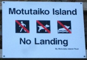
This cache is situated just about as close as you can get on the mainland on public land. No swimming is required!
Geology:
Motutaiko is formed out of a column of rhyolitic lava, connected to the geologic systems of Lake Taupo. The island was likely formed after an underwater magma vent's releases cooled and hardenedinto a cone, with Motutaiko forming the apex.about 6 100 years ago.
Ecological value:
This was the resting place of the muttonbird (black petrel) before its journey up the mountain to breed. Though the flight of the muttonbirds has stopped, possibly through habitat loss or over-hunting, the burrows still exist on the side of the mountain.
There is a large Black Shag (Kawau) colony on the western side of Motutaiko. It also is home to several endangered species such as the carniverous land snail, small skinks, and the white (kohourangi) and dwarf mistletoe plants.
The water around this island has protected it from mammals which have been introduced to New Zealand and create problems with the native plants and birds elsewhere.
See also: Stuff article
Getting to the cache:
This reserve is shortly after Motutere, and is best approached from the south. There is a short barrier, then a gap and you drive down into the reserve.
Turn left, and drive down into the picnic area. There is no sign naming the reserve, but a person who knows the area well told me it is the Waipehi reserve, named after the stream that flows into the lake there.
The cache is at the other end of the reserve from the picnic tables. It is a 400ml systema container, camoflaged with green tape. Please be stealthy when searching, you may be able to use your car as a screen to hide you from observers, which should lessen the chances of it going missing, as I will not be able to maintain it on a regular basis.