The Bay of Fundy is one of the Seven wonders of North America. It has the highest tides on earth which can range up to 16m in height. At low tide visitors can walk on the ocean floor where a variety of sea creatures cling to life. The listed coordinates will bring you the end of a boardwalk in Fundy National Park, located near the village of Alma. The park showcases a rugged coastline which rises up to the Canadian Highlands, the highest tides in the world, and more than 25 waterfalls.
The Bay of Fundy has the highest tides in the world which can be up to 16 meters, the height of a 5 story building! It is located between New Brunswick and Nova Scotia and is 170 miles of craggy cliffs, thundering waves, and ecological wonder. Tides are the periodic rise and fall of the sea caused by the gravitational pull of the moon and the sun on the Earth. Fundy’s tides are the highest in the world because of an unusual combination of factors: resonance and the shape of the bay. The water in the Bay of Fundy has a natural resonance (rocking motion) called seiche. You could compare this to the movement of water in a bathtub. Although the water in a bathtub sloshes from one end to the other and back again in a few seconds, it takes about 13 hours for the water in the bay to rock from the mouth of the bay to the head of the bay and back again. As the ocean tide rises and floods into the bay every 12 hours and 25 minutes, it reinforces the rocking motion. The shape and bottom topography also contribute to the high tides. The bay becomes narrower and shallower toward the upper bay and as a result water is forced higher up onto the shores.
Following the advice of Public Health experts and continue to make every effort to limit the spread of COVID-19, please keep a 2-meter distance with other visitors. Enjoy yourselves and please respect the other visitors.
Logging Requirements:
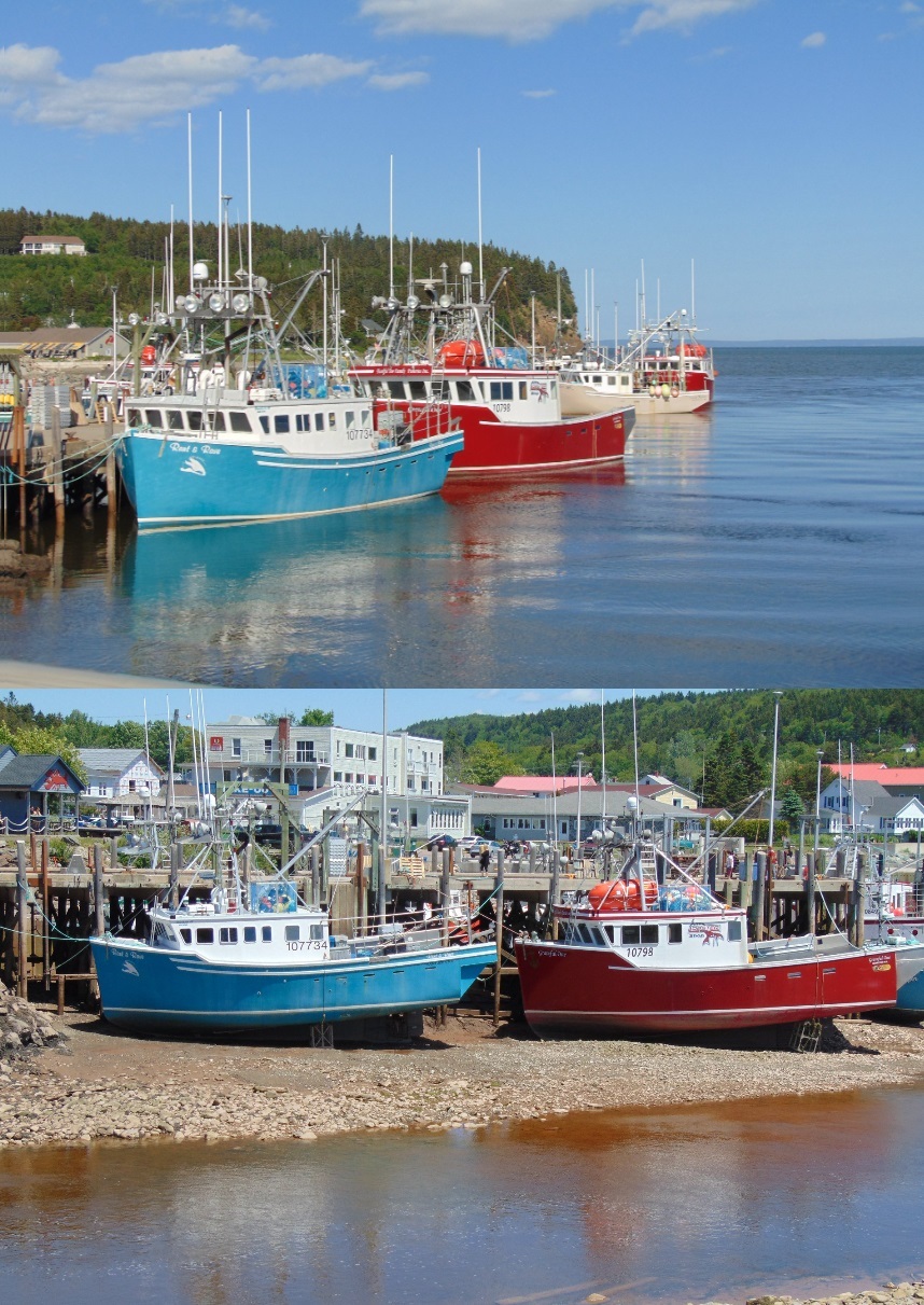
- At the time of your visit, is it high tide or low tide? Using the photo on the cache page as a guide, estimate the height of the tide.
- Sometimes the tide can influence the direction of water flow. Which direction is the water flowing in the Upper Salmon River (upstream or downstream)?
- Return to this location approximately 6 hours later. What is the tide now? Estimate the difference in height. Using the change in time, calculate the rate at which the tide rises/falls.
- Upload a before/after photo of the tides, with the boats. You will need to take two pictures. You do not need to be in the photo, though it is strongly recommended.